-
Hello, please take a minute to check out our awesome content, contributed by the wonderful members of our community. We hope you'll add your own thoughts and opinions by making a free account!
You are using an out of date browser. It may not display this or other websites correctly.
You should upgrade or use an alternative browser.
You should upgrade or use an alternative browser.
Pattern Novemburrr
- Thread starter SD
- Start date
pcbjr
Member
3 days realistically; 5 days in a dream ... ?This. Any forecast or pattern beyond 10 days is just water cooler talk.
Avalanche
Member
Any forecast beyond 10 days is snow talk.This. Any forecast or pattern beyond 10 days is just water cooler talk.
Avalanche
Member
True, but it seems like our last few Nov's were colder and Dec's were warmer. Of course, history has no bearing on right now.That’s what they said about November
pcbjr
Member


Sometimes the cartoons are right and sometimes wrong as they are just guidance. Makes for interesting wx forecasting discussions.
I love this time of year no matter the wx! And it doesn't get much better than today in November. Plus I'm loving the chilly month. That chilly Bleakies run from a couple of weeks ago was spot on! Hoping for a brisk stroll later! Had a good one last evening.
Jon
Member
Started out around 30F this morning, headed for 75F this afternoon. Certainly feels like it already. These 45F diurnal spreads out here are insane
76 & 36 in Charlotte Friday
Sent from my iPhone using Tapatalk
pcbjr
Member
Ditto and did you read my PM about the frontal passage yesterday? Fabulous ...Sometimes the cartoons are right and sometimes wrong. Makes for interesting wx forecasting discussions.
I love this time of year no matter the wx! And it doesn't get much better than today in November. Hoping for a brisk stroll later! Had a good one last evening.
... and cartoons and maps are just that ... not the Gospel ... ?

GeorgiaGirl
Member
It was pretty nippy outside this morning when I went walking. Should've worn a hat.
The high was 59 and the low was 33.
The high was 59 and the low was 33.
I think tomorrow we hit 50-52, the AFD mentions single digits, if winds die down, so could be around 40-45 degree range from Sunday high to Monday mornings low?
NBAcentel
Member
Horrific start to December

You could have just zoomed in and screenshotted those AK anomalies and I could have drawn the rest of the mapHorrific start to DecemberView attachment 95442View attachment 95445
This could be another one of those winters where KATL doesn’t get its first official freeze until mid December.
The angles of these troughs do look interesting but still eh 


Webberweather53
Meteorologist
Models were in pretty good agreement on early Dec til late yesterday. Now I wonder who's gonna blink first, literally the exact opposite patterns being depicted over N America on the GEFS & EPS.
View attachment 95377
View attachment 95378
Looks like the GEFS is gonna win this battle vs the EPS (again). Hope it stays warm enough for me to play golf around Christmas

Webberweather53
Meteorologist
Horrific start to DecemberView attachment 95442View attachment 95445
The last 10 Decembers in a row have been either above average or blowtorch warm. Even a week of warmth like that alone may be enough on its own to keep our temps above avg, even if we turn cold later. Womppppp
Six Mile Wx
Member
Ridiculously Resilient Ridge - Wikipedia
NBAcentel
Member
This sucks I just wonder if it’ll snow more then a inch eventually 


Good to see the eps at least stop the run to run lowering of heights in the pac with the 0z run but overall not a great pattern
NBAcentel
Member
Good to see the eps at least stop the run to run lowering of heights in the pac with the 0z run but overall not a great pattern
Very ugly all around to end off the EPS, solid +AO, +NAO and just this awkward looking Canadian ridge and -PNA, then a weakening Aleutian ridge, pretty much the complete opposite of what we want snow wise

NBAcentel
Member
?


Liking the less concentric look as you head lower in the atmosphere. ?
Webberweather53
Meteorologist
Looks like we’re headed for another warm winter
Well can't say I'm surprised and no point in complaining since it looks just like what it should given all we have going against us this winter. Just hope it flips like we know it would if it showed a great pattern that far out.This sucks I just wonder if it’ll snow more then a inch eventually View attachment 95452View attachment 95453View attachment 95455
That’s a great look !Very ugly all around to end off the EPS, solid +AO, +NAO and just this awkward looking Canadian ridge and -PNA, then a weakening Aleutian ridge, pretty much the complete opposite of what we want snow wise View attachment 95456
 ?
?Looks like we’re headed for another warm winter
We should have been using the analog method to forecast winters for years now instead of just blindly guessing, since it's so accurate!
Oooooof
NBAcentel
Member
Grit did pretty good last year with the -NAO analogs and even pacificWe should have been using the analog method to forecast winters for years now instead of just blindly guessing, since it's so accurate!
Oooooof
Looks like the MJO is going to start injecting itself into the pattern. Good news is the 2nd half of December might get intoGood to see the eps at least stop the run to run lowering of heights in the pac with the 0z run but overall not a great pattern
Grit is good. But he's been wrong plenty, just like everyone else. I enjoy reading all the winter forecasts and the good reasoning behind them. But at the end of the day, long range forecasting is little more than a coun flip.Grit did pretty good last year with the -NAO analogs and even pacific
That said, there is no reason to expect a cold winter. If you just take persistence alone, you will come up with a map that has yellows and oranges over the east. One day that will change. Nobody knows when, though. Even so, we can still have several bouts of winter weather.
NBAcentel
Member
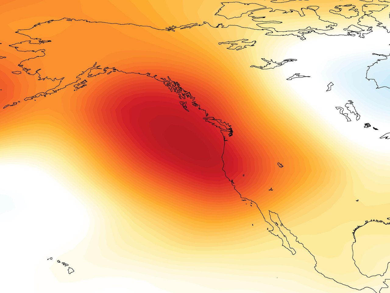
That’s eventually gonna couple and probably why were seeing the very warm look to start out December, that’s some unusual warmth showing up at least at 850mb for much of NA, o mean for example look at this week, there’s a stretched PV towards NA, and look, we have some of the coldest anomalies on our side (NA)Liking the less concentric look as you head lower in the atmosphere. ?

 but now we get the PV away back towards the other side and we’re getting these NA/US wall to wall warmth looks again, eventually a PV away from us would reflect, and this was the same exact reason why october had record breaking warmth across NA, the SPV was on the other side of the world

 trust me I want it to snow again, im seriously not even rooting for warmth at this point
Webberweather53
Meteorologist
We should have been using the analog method to forecast winters for years now instead of just blindly guessing, since it's so accurate!
Oooooof
The winters in each of those composites are all over the place for snow, the warmer +EPO group has complete trash in 2011-12 & 2005-06 but 1999-00 & 1988-89 that found a way to go off for a few weeks that year, but were otherwise torches. The other side is 1985-86 & 2000-01 (meh), & 2017-18 (great), 1995-96 (the only decent winter of the entire 1990s)
Bro this is early December ?? we will be alrightThis sucks I just wonder if it’ll snow more then a inch eventually View attachment 95452View attachment 95453View attachment 95455
Webberweather53
Meteorologist
This year reminds me a little of 2011-12 honestly. Cold got dumped into Alaska in December and never left the rest of the winterThat’s eventually gonna couple and probably why were seeing the very warm look to start out December, that’s some unusual warmth showing up at least at 850mb for much of NA, o mean for example look at this week, there’s a stretched PV towards NA, and look, we have some of the coldest anomalies on our side (NA) View attachment 95460View attachment 95461 but now we get the PV away back towards the other side and we’re getting these NA wall to wall warmth looks again, eventually a PV away from us would reflect, and this was the same exact reason why october had record breaking warmth across NA, the SPV was on the other side of the worldView attachment 95464View attachment 95462View attachment 95463 trust me I want it to snow again, I’m and seriously not even rooting for warmth at this point
NBAcentel
Member
The evolution that’s showing up is one that’s gonna be hard to break out of and is gonna take time, it’s just something that’ll hopefully change in models but La Niñas are typically better for the eastern US to start winter into mid winter, then the SE ridge becomes a issue the second half, it would suck wasting the first half away that favors better stuff in a La Niña for the east/southeastBro this is early December ?? we will be alright
tennessee storm
Member
That analog is honestly being touted as number one going into this winter . Why I can’t get to excited . It’s starting out just like that 11 12 winterThis year reminds me a little of 2011-12 honestly. Cold got dumped into Alaska in December and never left the rest of the winter
even in bad pattern winters we will sneak some sort of Evolution out at someee point in the winter to give us a shot. We can’t be throwing the towel in before we even get into December lol is all I’m sayingThe evolution that’s showing up is one that’s gonna be hard to break out of and is gonna take time, it’s just something that’ll hopefully change in models but La Niñas are typically better for the eastern US to start winter into mid winter, then the SE ridge becomes a issue the second half, it would suck wasting the first half away that favors better stuff in a La Niña for the east/southeast
Webberweather53
Meteorologist
People were cheering on the MJO several days ago because it looked like we were entering the cold phases. Going to run through 4-7 into early December, couldn’t get any warmer than this. No real signal for cold until/if we ever reach 8 (maybe** mid December?) Phase 7’s anomalies aren’t statistically significant except over the northern Plains


You've told us about 600 times we knowThat analog is honestly being touted as number one going into this winter . Why I can’t get to excited . It’s starting out just like that 11 12 winter
NBAcentel
Member
Mega March will provide I just feel iteven in bad pattern winters we will sneak some sort of Evolution out at someee point in the winter to give us a shot. We can’t be throwing the towel in before we even get into December lol is all I’m saying
Webberweather53
Meteorologist
The evolution that’s showing up is one that’s gonna be hard to break out of and is gonna take time, it’s just something that’ll hopefully change in models but La Niñas are typically better for the eastern US to start winter into mid winter, then the SE ridge becomes a issue the second half, it would suck wasting the first half away that favors better stuff in a La Niña for the east/southeast
Yes December is prime real estate for La Niña winters, wasting that away would really suck. Hopefully we give ourselves an opportunity mid to late month, if we can push the MJO into the W hem, we’ll have a shot. February is almost always above average or a torch in these kinds of winters, so the clock is already ticking. Certainly plenty reason to be discouraged rn