Avalanche
Member
Danville VA here I come!!!
Danville VA here I come!!!
We have to rake and blow them first. Urgh!!!Why can't leaves disintegrate as soon as they hit the ground?
I'm on the line so looks legit.
I mow mine or mulch themWe have to rake and blow them first. Urgh!!!
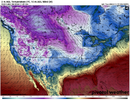
I don’t wanna waste the cold in November but at the same time I want the cold during the holidaysGEFS now has a major arctic air intrusion just at D10 window. It’s getting closer. EPS slighty slower View attachment 154341View attachment 154342
We're now getting close to the time of year (early Dec onward) where we can score a big storm. It's about "go time" to start hoping for winter storms.I don’t wanna waste the cold in November but at the same time I want the cold during the holidays
My guy understand the vibe. I like it brother.If and this is a big if all things stayed the same, we could be looking at a good ole traditional mid to upper 60's thanksgiving morning, with the passing front mid day. If you eat at lunch you're looking at rain/wind and mid 60's. If you eat in the afternoon you're looking at a windy clear evening with temps that have crashed well into the 40's and legit arctic feel.
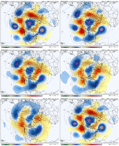
Let’s see what this GFS run does. TPV diving south into Canada, strong -EPO and an incoming trough around the Aleutian Islands. Lots of troughing underneath as well which keeps the look more interesting View attachment 154352

Dang almost the entire country in blue except for Florida.
We are going to be fighting that ridge nudge all Winter. Hoping we can somehow manage to properly drop a trough this Winter.
The 12z Canadian is slower getting the cold into the SE (for Thanksgiving) but looks more impressive with the push of arctic air towards the southeast on day 10 (Black Friday).We are going to be fighting that ridge nudge all Winter. Hoping we can somehow manage to properly drop a trough this Winter.

I'm sitting at 2.42" and still raining steadily. Way over performed.3.28” so far here to end whatever drought the last one didn’t. Just shot a charity skeet tournament. That type of rain will find any hole the rain gear.
Models vastly busted on this event here. 2.3 now..I'm sitting at 2.42" and still raining steadily. Way over performed.
Yep get the nose of the pac jet between the aleutians and Hawaii and we will be goodThis GEFS run is weenie tastic. Around day 10 and onwards it starts to extend the pacific jet to a favorable location View attachment 154362
Yeah I like this follow on low / trough coming off E Asia days 8-13 after an expansive Siberian high pressure drops a cold surge into China. This reinforces the -WPO / -EPO North Pac ridging and tries to push it east. All the modeling has it to some degree. The AI Euro was early on itThis GEFS run is weenie tastic. Around day 10 and onwards it starts to extend the pacific jet to a favorable location View attachment 154362

What’s the potential downstream impact of that? Asking for a friendYep get the nose of the pac jet between the aleutians and Hawaii and we will be good
