We’ve got some NW flow stuff showing up for the mountains in the extended forecast. Also a chance of snow behind that front next weekend up in the mountains. I’ll be up there at the Indian casino ?? 

The game was moved to Detroit's Ford Field because of the conditions!Bulls browns game tomorrow. If only it were today or yesterday. Epic conditions View attachment 123963
Currently 53.2 after a high of 56.1

Theres an official 77” total now!!??I saw a 65 inch report at 10pm last night. No doubt someone could eclipse 72 inch mark before all is said and done. Saw one youtube video of a chaser in chest deep snow.
Most people in the south get 75% of their yearly snowfall in one event. GSP is line 5” a year, so one snow will do herWhats happening in Buffalo is nuts! They are getting some 2/3rd of their annual snowfall in one storm! Wow! That would be the equivalent of us getting a 3 inch snowstorm! I can not imagine getting 75% of my annual snowfall avg in one snow. Crazy stuff. `

dog water
Ragin -PNA
Sent from my iPhone using Tapatalk

Ok, we get it.
Ragin -PNA
Sent from my iPhone using Tapatalk
We get some of our biggest cold outbreaks with the WAR nudging into the Carolinas
i'll take 6" of snow in my back yard, over 72" in another person's back yard. Snow in your yard is more special.After seeing 72” of snow in Watertown this weekend, nothing the south has to offer will ever be the same lol.


I mostly agree; our climo is late December to late February. But, we can start hoping for a storm in early December. We've had some big ones in the first half of the month.I could care less about these looks in early December. We're not climo in these parts. Give me these challenges in late Dec and beyond

Yep. I consider DJF fair gameI mostly agree; our climo is late December to late February. But, we can start hoping for a storm in early December. We've had some big ones in the first half of the month.
Here's some recent highlights:
Dec 4 2000, Dec 4 2002, Dec 4 2010, Dec 12 2010, Dec 8 2017, and
Dec 8 2018
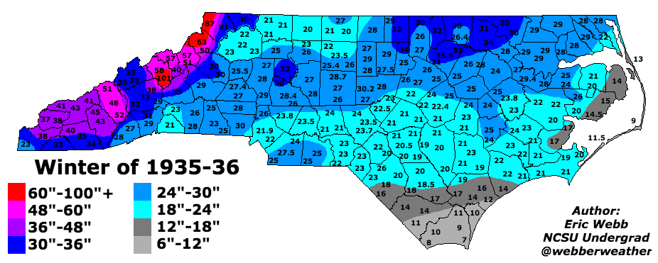
View attachment 123981
About
In order to create and maintain as long and reliable record of winter storms as possible in North and South Carolina, the following list of winter storm and seasonal snow/sleet maps for the states of...www.webberweather.com


Yeah but it’s lost the category 4 hurricane that gives us a blizzard… lol

The angle of the PNA is not right! ?


Id take them 12 months out of the year. Anytime is a good time!I could care less about these looks in early December. We're not climo in these parts. Give me these challenges in late Dec and beyond

 ️??
️??
1055 hp coming out of Canada. That verifies 99.5% of the time. We are good boys.GFS was setting up for a glory run! Old school winter storm, ala TWC 7 day planner style!
25.7 imby25.5 in Henderson, actually up from 24.6 about 45min ago

 (19).gif")