Now on the ground.That's a very strong rotation
-
Hello, please take a minute to check out our awesome content, contributed by the wonderful members of our community. We hope you'll add your own thoughts and opinions by making a free account!
You are using an out of date browser. It may not display this or other websites correctly.
You should upgrade or use an alternative browser.
You should upgrade or use an alternative browser.
Severe New Years Severe Weather Event
- Thread starter Snowfan
- Start date
HSVweather
Member
thanksgivingbrown
Member
Storm near Cherokee is the best looking storm atm
Apparently they double warned it.
HSVweather
Member
Lostnthaweather85
Member
HSVweather
Member

SUMMARY...The Risk of a few tornadoes, damaging wind gusts, and
isolated large hail may increase during the next few hours.
DISCUSSION...A mix of multicell clusters and transient supercell
structures should continue tracking east-northeastward from eastern
MS across parts of northern to west-central AL during the next few
hours. Here, a moist airmass (middle/upper 60s dewpoints) is
contributing to around 1000 J/kg MLCAPE where the latest VWPs show
0-6 km bulk shear of 60-70 knots. While storms have struggled across
the warm sector thus far owing to limited large-scale forcing for
ascent and weak low-level convergence, a low-level jet is expected
to overspread the area which may support a few longer-lived
multicell clusters and supercells over the next few hours. The
latest VWPs from GWX and HTX show 0-1 km SRH values of 250-300 m2/s2
ahead of the ongoing convection, which will support a risk of a few
tornadoes, damaging wind gusts, and isolated large hail with any
sustained supercells or intense multicells across the area.
HSVweather
Member

Rotation appears to be getting stronger in southern Lamar county.
HSVweather
Member
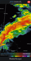
 Tornado warning coming for northern Madison county AL
Just got warned.View attachment 100853Tornado warning coming for northern Madison county AL
Getting a bit of a hook right now.View attachment 100853Tornado warning coming for northern Madison county AL
HSVweather
Member
Appears to be a debri signature, hard to see.
HSVweather
Member

New warning issued for the cell that passed near Columbus.
thanksgivingbrown
Member
That storm entering Morgan County bears watching. Entering heaviest populated areas in North Alabama.