Z
Zander98al
Guest
Uh oh. Inflow is ramping up. May have broke
Might be clutter. Not sure though, strong rotation thoughCC debri now
It is strengthening though almost a huge donut hole on itMight be clutter. Not sure though, strong rotation though

 Storm south of Belmont has inflow notch and rotation stronger
 New MCD
Mid level lapse rates are barely 6C which is likely the reason why storms haven’t gotten going like they were suppose toView attachment 100759New MCD
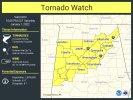
The severe weather threat for Tornado Watch 3, 4, 5 continues.
SUMMARY...Severe thunderstorm threat, including the potential for a
tornado, continues ahead of the outflow boundary from northeast MS
across northern AL into middle TN.
DISCUSSION...Despite an abundance of warm sector development, most
of this activity has failed to materialize into supercells thus far.
The only exception is the pair of northeastward moving supercells,
one over far north-central MS and the other over far northwest AL.
Westernmost cell in this pair has begun to interact with the outflow
while the easternmost cell is still slightly ahead of the boundary
and may be able to remain more intense for a bit longer.
While some weakening of the buoyancy has occurred, this narrow
corridor ahead of the outflow still represents the best area for
potential severe thunderstorms for the next few hours.
Oh wow they upgraded the wording. Must be expecting more when sun goes downNew tornado watch.
They said the low level jet is gonna ramp up more after dark. That's why they changed the wording.Oh wow they upgraded the wording. Must be expecting more when sun goes down
 It’s going to cross I65 soon
That's a very strong rotationView attachment 100779It’s going to cross I65 soon
 Debri now