-
Hello, please take a minute to check out our awesome content, contributed by the wonderful members of our community. We hope you'll add your own thoughts and opinions by making a free account!
You are using an out of date browser. It may not display this or other websites correctly.
You should upgrade or use an alternative browser.
You should upgrade or use an alternative browser.
Severe New Years Severe Weather Event
- Thread starter Snowfan
- Start date
HSVweather
Member
 That one about to cross the state line seems like it could produce shortly. Has nothing blocking inflow from the south.
HSVweather
Member
 This is headed toward the Shoals/Florence area next. Very rural area right now until it approaches highway 72
HSVweather
Member
Jeff Piotrowski is in perfect position to intercept and live streaming now on TwitterView attachment 100668This is headed toward the Shoals/Florence area next. Very rural area right now until it approaches highway 72
HSVweather
Member
 Tiny storm entering north Tuscaloosa county.
Z
Zander98al
Guest
This supercell in north MS . Looks like it's about to turn into a beast 
HSVweather
Member
Was just about to post, agree, lightning with it picking upThis supercell in north MS . Looks like it's about to turn into a beast View attachment 100685
Z
Zander98al
Guest
Nothing really get any strong rotation too it. Might be because of the poor lapse rates, but idk
Z
Zander98al
Guest
Wait. The warm nose hasn't even broke. So most of these probably aren't even convective yet lol
gawxnative
Member
Mesoscale Discussion 9 |

|
Mesoscale Discussion 0009 NWS Storm Prediction Center Norman OK 0157 PM CST Sat Jan 01 2022 Areas affected...Northern MS into Far Northern AL and Southern Middle TN. Concerning...Tornado Watch 3...4...5... Valid 011957Z - 012130Z The severe weather threat for Tornado Watch 3, 4, 5 continues. SUMMARY...Development of a few discrete supercells capable of producing tornadoes and damaging wind gusts possible from northern MS into far northern AL and southern middle TN. DISCUSSION...Recent observations suggest the outflow boundary moving through western TN has become less defined near the TN/MS border, suggesting that much of warm sector across northern MS and adjacent northern AL/southern middle TN will likely stay free from the influence of this boundary. Additionally, the amount and intensity of the warm sector cells has continued to increase, with several cells producing lightning over the past hour. This development is occurring within an environment characterized by warm and moist low-levels and strong vertical shear. Recent GWX VAD also sampled 300 m2/s2 of 0-1 km storm-relative helicity. Expectation is for the storms currently in northern MS to organize/intensify further as they continue northeastward into a more sheared downstream environment. ..Mosier.. 01/01/2022 |
Z
Zander98al
Guest
Heading northeast to Birmingham. Not rooted to the surface, but pretty strong rotation 
Z
Zander98al
Guest
This is a very healthy looking on cell on radar. I think this one near where the HRRR gets updraft swaths on. 
That isn’t good at all. The models were showing biggest issue being with a warm layer in the lower levels. That sounding shows really good low level lapse rates. That mid level layer will probably be eroded.
Z
Zander98al
Guest
Starting to develop a big inflow notch it seems.
HSVweather
Member

HSVweather
Member
SBCAPE of only 257?
Z
Zander98al
Guest
Getting a decent notch, wonder if those cap has broke?

Z
Zander98al
Guest
Uh oh. Inflow is ramping up. May have broke
thanksgivingbrown
Member
Z
Zander98al
Guest


HSVweather
Member
CC debri now
HSVweather
Member

Z
Zander98al
Guest
Might be clutter. Not sure though, strong rotation thoughCC debri now
Z
Zander98al
Guest
It is strengthening though almost a huge donut hole on itMight be clutter. Not sure though, strong rotation though
Z
Zander98al
Guest
Watching the cell over the ematower on omegaradar
HSVweather
Member
 Storm south of Belmont has inflow notch and rotation stronger
Z
Zander98al
Guest
HSVweather
Member
 New MCD
The severe weather threat for Tornado Watch 3, 4, 5 continues.
SUMMARY...Severe thunderstorm threat, including the potential for a
tornado, continues ahead of the outflow boundary from northeast MS
across northern AL into middle TN.
DISCUSSION...Despite an abundance of warm sector development, most
of this activity has failed to materialize into supercells thus far.
The only exception is the pair of northeastward moving supercells,
one over far north-central MS and the other over far northwest AL.
Westernmost cell in this pair has begun to interact with the outflow
while the easternmost cell is still slightly ahead of the boundary
and may be able to remain more intense for a bit longer.
While some weakening of the buoyancy has occurred, this narrow
corridor ahead of the outflow still represents the best area for
potential severe thunderstorms for the next few hours.
NBAcentel
Member
Mid level lapse rates are barely 6C which is likely the reason why storms haven’t gotten going like they were suppose toView attachment 100759New MCD
The severe weather threat for Tornado Watch 3, 4, 5 continues.
SUMMARY...Severe thunderstorm threat, including the potential for a
tornado, continues ahead of the outflow boundary from northeast MS
across northern AL into middle TN.
DISCUSSION...Despite an abundance of warm sector development, most
of this activity has failed to materialize into supercells thus far.
The only exception is the pair of northeastward moving supercells,
one over far north-central MS and the other over far northwest AL.
Westernmost cell in this pair has begun to interact with the outflow
while the easternmost cell is still slightly ahead of the boundary
and may be able to remain more intense for a bit longer.
While some weakening of the buoyancy has occurred, this narrow
corridor ahead of the outflow still represents the best area for
potential severe thunderstorms for the next few hours.
Z
Zander98al
Guest
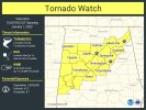
Oh wow they upgraded the wording. Must be expecting more when sun goes downNew tornado watch.
They said the low level jet is gonna ramp up more after dark. That's why they changed the wording.Oh wow they upgraded the wording. Must be expecting more when sun goes down
HSVweather
Member
 It’s going to cross I65 soon
Z
Zander98al
Guest
That's a very strong rotationView attachment 100779It’s going to cross I65 soon
thanksgivingbrown
Member
debris signature near Elkton
HSVweather
Member
 Debri now