• Hello, please take a minute to check out our awesome content, contributed by the wonderful members of our community. We hope you'll add your own thoughts and opinions by making a free account!

Severe New Years Severe Weather Event

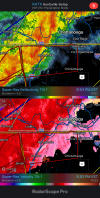
Another spin up might be forming on the Alabama/Georgia state line. May need to extend warning into Georgia.34D7EC57-E86D-4275-8DF7-ADF3148CA4FA.png
 
widespread thunderstorm warning throughout the CHA metro area, but literally zero lightning/thunder. nothing at all showing on lighningmap.org
radar looks rather threatening though. just weird
 
Why are the storms out front failing to strengthen?

We are missing a key ingredient, lift maybe? Just a porchcaster but the air and dew just seem primed
 
Last edited:
Jan 2, 2022 1300 UTC Day 1 Convective Outlook​
Updated: Sun Jan 2 12:34:24 UTC 2022 (Print Version | 20220102 1300Z Day 1 shapefile | 20220102 1300Z Day 1 KML)​
CategoricalTornadoWindHail
Pop. Cities CWAs RFCs Interstates Counties ARTCC FEMA Tribal
map_background.gif
day1otlk_1300.gif
Categorical Day1 1300Z Outlook
Day 1 Risk​
Area (sq. mi.)​
Area Pop.​
Some Larger Population Centers in Risk Area​
SLIGHT​
93,927​
8,336,729​
Tallahassee, FL...Savannah, GA...Columbia, SC...Charleston, SC...Macon, GA...​
MARGINAL​
41,968​
5,247,227​
Jacksonville, FL...Mobile, AL...Columbus, GA...Gainesville, FL...Fayetteville, NC...​
Forecast Discussion
SPC AC 021234

Day 1 Convective Outlook
NWS Storm Prediction Center Norman OK
0634 AM CST Sun Jan 02 2022

Valid 021300Z - 031200Z

...THERE IS A SLIGHT RISK OF SEVERE THUNDERSTORMS TODAY THROUGH
TONIGHT ACROSS PARTS OF THE SOUTHEAST/CAROLINAS...

...SUMMARY...
Thunderstorms with damaging wind gusts, a few tornadoes, and
isolated large hail are possible across parts of the Southeast and
Carolinas today through tonight.

...Southeast AL area today to the eastern Carolinas overnight...
A pre-frontal band of convection has sagged southeastward overnight
across southeast MS, central/southern AL, north GA, and the Piedmont
of the Carolinas. This convection is well ahead of the stronger
synoptic cold front/Arctic air mass now surging across the lower MS
Valley and northwest Gulf of Mexico. This pre-frontal band may
continue to focus convection during the day from southeast AL into
GA, where gradual cooling aloft (2-3 C cooling in the 700-400 mb
layer compared to current profiles) and a little low-level
warming/moistening will contribute to MLCAPE increasing to 1500-2000
J/kg by late afternoon. Given the continued strong deep-layer
vertical shear, the stronger storms from southeast AL into southwest
GA will be capable of producing damaging winds, isolated large hail,
and perhaps a tornado or two.

The primary cyclogenesis will occur tonight from west
central/southwest GA into the Carolinas (likely moving along the
residual pre-frontal convective boundary), in response increasing
height falls aloft with the amplifying midlevel trough. Related
increases in forcing for ascent, low-level warm/moist advection, and
strengthening vertical shear (both deep-layer shear and low-level
hodograph curvature) should be sufficient to support convection
persisting overnight night in a broken band along or just ahead of
the synoptic cold front and near the deepening surface cyclone.
Buoyancy will be somewhat limited overnight (MLCAPE near 500 J/kg)
from southeast GA into the coastal plains of the Carolinas, but
effective bulk shear of 60-70 kt and effective SRH near 300 m2/s2
will favor embedded supercells and/or line segments capable of
producing damaging gusts and a couple of tornadoes.

..Thompson/Kerr.. 01/02/2022
 
Back
Top