rydermark48
Member
Hey, I’m new here from northeast tn. Bummed out so far this year with no snowfall as of yet.
Who tweeted this
Sent from my SM-J320VPP using Tapatalk

With this current NAM run being a major change from the last few runs, I'd be willing to not take it *too* seriously. It definitely bears watching though. Will continue to monitor.
Lol I would love to see 5 inches from this, but until I see the system tomorrow afternoon, we won't know the truth. The reality will be seen then. Until then, all we have is what's happening now and the models. The NAM wasn't a good trend though this run. Let's get a good ICON and RGEM.The December storm overperformes the night before as well. We all know how that ended up as well.... just something to think about
I Agree, im not counting on these LR models, heck short range at this matter lol. Radar watch in full effect. I feel as this will up totals unexpectedThat's actually impressive to say the least in that area-wide they're going to end up w/ 3-7" in portions of KY & TN...
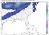
Here's what last night's 3 km NAM showed. At best 2-3" if you account for ratios... Not even close. Bears watching for those downstream.
View attachment 3042
Yeah it could be a blip, hopefully.
Good we want this to slow down and tilt more . Hope it stays that way for hours lolBand of snow just to my northwest but I'm not seeing any movement to the south and east at all
Glad to hear that. Maybe a wonky run. It seems so far off from the others lately.Well, this run of the NAM just purplexed me. Develops a SFC reflection and low basically offshore NC/VA and by hr48, a clear cut SFC low up offshore of New England ... that didn't quite make much sense ...


It wasn't bad for usGlad to hear that. Maybe a wonky run. It seems so far off from the others lately.

Good signs with this. Liking where we could be headed.Total nighttime snow and sleet accumulation of 3 to 5 inches possible.
Ya don't get. Mega jet streak and nada really. Hmm okWell, this run of the NAM just purplexed me. Develops a SFC reflection and low basically offshore NC/VA and by hr48, a clear cut SFC low up offshore of New England ... that didn't quite make much sense ...
Actually looks a little more for us.It wasn't bad for us
Sent from my SM-G955U using Tapatalk
Yeah In fact this is a trend to the models that have had the jackpot further eastActually looks a little more for us.
Kinda surprised there wasn't more down your way. This dry layer isn't terribleYa don't get. Mega jet streak and nada really. Hmm ok

Kinda surprised there wasn't more down your way. This dry layer isn't terrible
Sent from my SM-G955U using Tapatalk
Soundings are good. Saturated with some decent omega in the dgz. I'll take it.Actually looks a little more for us.

High res guidance busted horribly even last night w/ the snow that's currently falling over southwestern KY & portions of TN. NWS currently expecting 3-7" and even if you account for higher SLRs, they're going to experience nearly double what was forecast by any high res model. Epic fail.
View attachment 3046
View attachment 3044
View attachment 3047
I agree and there is 6 hours where the column is fully saturatedKinda surprised there wasn't more down your way. This dry layer isn't terrible
Sent from my SM-G955U using Tapatalk
odd, I got higher totals in north ala from the same thingIt wasn't bad for us
Sent from my SM-G955U using Tapatalk

3-5 for my area according to this map. Looking at the radar I don’t see how I only end up with 2 inches. I thought I heard the weather channel guy say Paducah Kentucky got 6 inches of snow so far. Is this true?Updated forecast map from Firsthand Weather:

odd, I got higher totals in north ala from the same thing
View attachment 3048
2” to 4” across the triangle and all snow. Really good.Actually looks a little more for us.
3k nam vs 12kodd, I got higher totals in north ala from the same thing
View attachment 3048

Maybe feedback issues again. ???