NBAcentel
Member
I got a good feeling as we build blocking over the top we will be able to start squashing the SER more as we get into the medium range, but I still highly doubt we come away with anything other than 40's and 50's for highs.
Probably more like few 40s/50s sprinkled into really warm periods, like the EPS plumes, looks like we get another strong -PNA which will advect in some really warm air, even with a -NAO, the main TPV is gonna be near scandanavia, pacific polar is gonna be the best bet on any cool, and that’s moderating quickly as we enter springI got a good feeling as we build blocking over the top we will be able to start squashing the SER more as we get into the medium range, but I still highly doubt we come away with anything other than 40's and 50's for highs.
Yeah no doubt spring is fast approachingProbably more like few 40s/50s sprinkled into really warm periods, like the EPS plumes, looks like we get another strong -PNA which will advect in some really warm air, even with a -NAO, the main TPV is gonna be near scandanavia, pacific polar is gonna be the best bet on any cool, and that’s moderating quickly as we enter spring

You'll get your cold albeit transient, but if the Euro continued we were fixing to have a huge dump out west again so rinse and repeat. At least we have the -NAO to keep from getting this week part 2 more than likely. But if anyone is expecting winter weather, I'd damper those expectations considerably. The Pacific is just too wrecked to think we are going to get anything other than CAD right now at best.
Probably more like few 40s/50s sprinkled into really warm periods, like the EPS plumes, looks like we get another strong -PNA which will advect in some really warm air, even with a -NAO, the main TPV is gonna be near scandanavia, pacific polar is gonna be the best bet on any cool, and that’s moderating quickly as we enter spring
Yeah that system has my eye for sureMy fro. What think about todays 12z euro run long range ? Day 9. 10 course , but interesting say least
Yeah for sure. Definitely not going to be the 1st week of March. Looks like around the 10th hopefully we started to trend colder but we are about out of time for winter weather but I'm just hoping for a return to a least average or below average temps or at least cold at night. Who knows what will happen for us going forward but out west will continue to be a lock for cold and snow. Looks like it's going to take a miracle from here out to get a day with highs in the upper 40s and lows in the upper 20s. I hate the southeast weather in winter but it's my home and has been for 40s. Looking forward to colder days ahead. If I didn't have hope I couldn't make it living around here.To me, it's interesting the pna is still hanging on out west with movement of the mjo and SSW we have attained. Could be wrong but I still feel March will be cold at some point but too late when it happens.


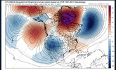
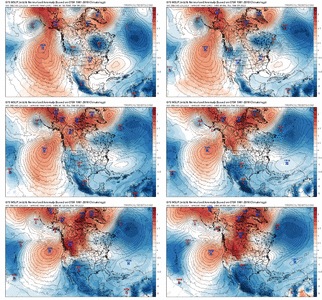
I still believe winter returns in week 2 of march. Breaking down -PNA possibly flipping to + .. anomalous west based -NAO.. 50/50 for fun? .. building up cold high pressures. Solid phase 8 MJO .. it screams last hurrah possibility. A very similar look to what we were dealing with in December. Best look we’ve had since then. Obviously this is operational model but the general premise I see happening around week 2 of march or so .. too little too late? Maybe so.. but I’ll take my odds in this dumpster fire of a winter and regardless it’ll be a snap back reality for many that we’re still in the cold season. View attachment 133514
View attachment 133513View attachment 133515
That’s a better look in terms of the MJO if you want cold. Right on cue the GEFS seems to suppress the ridge around March 6th.
But it’s a ways off and a lot can change. As for right now, the warmth is real and it’s impressive 70° at 7:30 AM in Alpharetta. What a time to be alive.
Sent from my iPhone using Tapatalk
If the average high is over 60 are you really still in the cold season? If the calendar says March are you really truly in the cold season nicky?I still believe winter returns in week 2 of march. Breaking down -PNA possibly flipping to + .. anomalous west based -NAO.. 50/50 for fun? .. building up cold high pressures. Solid phase 8 MJO .. it screams last hurrah possibility. A very similar look to what we were dealing with in December. Best look we’ve had since then. Obviously this is operational model but the general premise I see happening around week 2 of march or so .. too little too late? Maybe so.. but I’ll take my odds in this dumpster fire of a winter and regardless it’ll be a snap back reality for many that we’re still in the cold season. View attachment 133514
View attachment 133513View attachment 133515
Ehhhhhhhhhh ...... Maybe in ATL but in traditional areas that is not true at all. We just haven't gotten winter weather out of it. Hell last week 80% of the board was in the 60's and 70's while CAD areas in the Carolinas were in the low to mid 50's.The trend on CAD events recently have been to underperform.
Sent from my iPhone using Tapatalk


192 hours. NW trend puts Chicago in the ?
That's where the 0z Euro had it ?192 hours. NW trend puts Chicago in the ?


Not if you like winter.
Sent from my iPhone using Tapatalk
Ehhhhhhhhhh ...... Maybe in ATL but in traditional areas that is not true at all. We just haven't gotten winter weather out of it. Hell last week 80% of the board was in the 60's and 70's while CAD areas in the Carolinas were in the low to mid 50's.
Looks almost like March ‘93, except not really.
Yeah looking at the GFS (as depicted), day 9 & 10 would maybe provide a light freeze/frost for some; but other than that nothing (above freezing nights). I wonder if the NWS would start their frost/freeze packages (warnings) early. After all this warm weather there is going to be an early leaf out.I wouldn’t be looking for cold until the second week of march. Anything before that I’d worry about severe weather or cold rains

LOL
A massive winter storm could bring blizzard-like conditions to Los Angeles this weekend. For the first time since 1989, the National Weather Service has issued a blizzard warning for Friday (February 24) and Saturday in Los Angeles and Ventura counties.
This has happened before in my lifetime.
Nothing like a nice coast to coast trough lol
Portland just saw its 2nd snowiest day on record(10.8 inches) on Wednesday. Literally feels like everywhere but the SE has seen extreme winter weather over the past few years.
I really hope we don’t get a 4th year La Nina next winter. This is truly rock bottom as far as winters are concerned.
Portland just saw its 2nd snowiest day on record(10.8 inches) on Wednesday. Literally feels like everywhere but the SE has seen extreme winter weather over the past few years.
I really hope we don’t get a 4th year La Nina next winter. This is truly rock bottom as far as winters are concerned.
