Tarheelwx
Member
The biggest impact will be snow accumulating on the trees. Heavy wet snow on leafed out or fully blossomed trees could lead to a lot of problems.
TW
TW

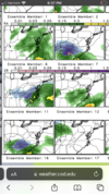
Oooh so close, just need it to hold further east lol. But yeah 12z HRRR is umm almost a big deal
DoneSomebody should start a thread
You are correct. When I saw 2.5” stick to the ground on 4/2/2019 IMBY, it stuck to and covered the fully leaved trees first… we had two Bradford pears in our front yard that literally split in half down the middle of the trunk just from having snow on them for 2 hours. Warm ground temps won’t prevent snow from piling up on trees.The biggest impact will be snow accumulating on the trees. Heavy wet snow on leafed out or fully blossomed trees could lead to a lot of problems.
TW
 wind
windI haven’t really paid much attention to this, but I’m assuming that this snowfall potential is coming from an area of strong FGEN forcing causing the column to collapse and produce a period of snow. If it is, then honestly, I would pay very little attention to the NAM as it doesn’t do well at all with those set ups. The HRRR and the RAP typically sniff those out first…2/6/2021 is a great example of that.Outside of mainly the border counties, the 12z NAM is not too enthusiastic about flakes, unfortunately.
The GFS and CMC are still advertising big dog potential around day 9. A little too suppressed, but with ample cold air on today's runs. Right where we want it?

That makes some sense looking at the drought monitor. The heat ridge looks to set up from Kansas down into TX unless things change.The CFS's summer projections are interesting. Mild and wet in the east and west and warm and dry in the central areas.
Agreed… it sounds like it’s taking the shape of a typical neutral ENSO summer going into a weak El Niño in the fall.That makes some sense looking at the drought monitor. The heat ridge looks to set up from Kansas down into TX unless things change.
That makes some sense looking at the drought monitor. The heat ridge looks to set up from Kansas down into TX unless things change.
Didn't that happen last year with La Nina?
Sent from my iPhone using Tapatalk