• Hello, please take a minute to check out our awesome content, contributed by the wonderful members of our community. We hope you'll add your own thoughts and opinions by making a free account!

Pattern May Thread

My Tempest is at 1.15", but it is generally 10-20% low, there are two stations on each side of me that I keep tabs on and one has 1.46" and 1.36".
Also, we discovered back in December, thanks to Ward, to turn off the rain check feature (I think the default setting is on), once I did so my numbers came up more in line with other reporting stations and radar estimates.

I turned off the Rain Check feature. I’m more interested in rain totals IMBY than overall community totals.
 
83/70 right now with a primarily S wind. Looks like the backdoor front is lingering near by. Really want to be along or just north today to wait maximize heavy rain potential
 
Also, we discovered back in December, thanks to Ward, to turn off the rain check feature (I think the default setting is on), once I did so my numbers came up more in line with other reporting stations and radar estimates.


I look around at some of the stations near me and I would love to meet these guys that spend the money on a tempest and put it under a tree or deck and constantly report 0.00". I had the rain check feature on for a while and couldn't understand why I was so low but that was absolutely it.
 
AI driven or not, i almost always take summer nado forecasts with a grain of salt. There's a paper i saw years ago (but still feels very true, it has completely stuck with me) that basically implied once you get into summer regimes you can basically throw STP and all of the model driven supercell/tornado parameters out (or at least respect them way less) as their accuracy of predicting outbreaks goes down a lot.
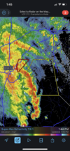
Nothing widespread but tornado threat certainly wasn’t zero here with a stout QLCS capable of the obvious kinks for some tornado development E6B3E6F2-8638-402F-9DBE-E644A1BEF160.png
 
Severe Weather Statement
National Weather Service Raleigh NC
259 PM EDT Mon May 23 2022

NCC037-105-125-231930-
/O.CON.KRAH.TO.W.0016.000000T0000Z-220523T1930Z/
Moore NC-Lee NC-Chatham NC-
259 PM EDT Mon May 23 2022

...A TORNADO WARNING REMAINS IN EFFECT UNTIL 330 PM EDT FOR
NORTHWESTERN MOORE...NORTHWESTERN LEE AND SOUTHWESTERN CHATHAM
COUNTIES...

At 259 PM EDT, a severe thunderstorm capable of producing a tornado
was located near Carthage, moving northeast at 40 mph.

HAZARD...Tornado.

SOURCE...Radar indicated rotation.

IMPACT...Flying debris will be dangerous to those caught without
shelter. Mobile homes will be damaged or destroyed. Damage
to roofs, windows, and vehicles will occur. Tree damage is
likely.

This dangerous storm will be near...
Carthage around 305 PM EDT.
Sanford and Goldston around 325 PM EDT.

Other locations impacted by this tornadic thunderstorm include
Cumnock, Harpers Crossroads, Highfalls, Robbins and Glendon.
 
Severe Weather Statement
National Weather Service Raleigh NC
303 PM EDT Mon May 23 2022

NCC093-125-165-231915-
/O.CON.KRAH.SV.W.0103.000000T0000Z-220523T1915Z/
Moore NC-Scotland NC-Hoke NC-
303 PM EDT Mon May 23 2022

...A SEVERE THUNDERSTORM WARNING REMAINS IN EFFECT UNTIL 315 PM EDT
FOR CENTRAL MOORE...NORTH CENTRAL SCOTLAND AND NORTHERN HOKE
COUNTIES...

At 303 PM EDT, severe thunderstorms were located along a line
extending from near Carthage to Southern Pines to 6 miles east of
Hoffman, moving northeast at 55 mph.

HAZARD...60 mph wind gusts.

SOURCE...Radar indicated.

IMPACT...Expect damage to roofs, siding, and trees.

Locations impacted include...
Southern Pines, Carthage, Pinehurst, Aberdeen, Whispering Pines,
Pinebluff, Foxfire, Taylortown, Vass and Cameron.
 
You just got a new tempest didn't you? Its probably a little low, they are getting better, but are still generally short.
I’ve had for awhile now but a bird took a massive dump on it and it hasn’t registered as good lately.
 
Tornado Warning
NCC063-069-077-183-232045-
/O.NEW.KRAH.TO.W.0017.220523T2006Z-220523T2045Z/

BULLETIN - EAS ACTIVATION REQUESTED
Tornado Warning
National Weather Service Raleigh NC
406 PM EDT Mon May 23 2022

The National Weather Service in Raleigh has issued a

* Tornado Warning for...
Southern Granville County in central North Carolina...
Northeastern Wake County in central North Carolina...
Southeastern Durham County in central North Carolina...
Northwestern Franklin County in central North Carolina...

* Until 445 PM EDT.

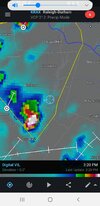
* At 406 PM EDT, a severe thunderstorm capable of producing a tornado
was located near Durham, moving east at 40 mph.

HAZARD...Tornado.

SOURCE...Radar indicated rotation.

IMPACT...Flying debris will be dangerous to those caught without
shelter. Mobile homes will be damaged or destroyed.
Damage to roofs, windows, and vehicles will occur. Tree
damage is likely.

* This dangerous storm will be near...
Raleigh around 410 PM EDT.
Wake Forest around 430 PM EDT.
Franklinton around 440 PM EDT.

Other locations impacted by this tornadic thunderstorm include Falls
Lake, Falls Lake State Rec Area, Youngsville, Falls Lake Boat Ramp
and Purnell.
 
Tornado Warning
NCC063-069-077-181-232045-
/O.NEW.KRAH.TO.W.0018.220523T2011Z-220523T2045Z/

BULLETIN - EAS ACTIVATION REQUESTED
Tornado Warning
National Weather Service Raleigh NC
411 PM EDT Mon May 23 2022

The National Weather Service in Raleigh has issued a

* Tornado Warning for...
Southwestern Vance County in central North Carolina...
Southern Granville County in central North Carolina...
Central Durham County in central North Carolina...
Northwestern Franklin County in central North Carolina...

* Until 445 PM EDT.

* At 411 PM EDT, a severe thunderstorm capable of producing a tornado
was located near Butner, or 7 miles northeast of Durham, moving
northeast at 40 mph.

HAZARD...Tornado.

SOURCE...Radar indicated rotation.

IMPACT...Flying debris will be dangerous to those caught without
shelter. Mobile homes will be damaged or destroyed.
Damage to roofs, windows, and vehicles will occur. Tree
damage is likely.

* This dangerous storm will be near...
Creedmoor and Butner around 425 PM EDT.
Franklinton and Kittrell around 445 PM EDT.

Other locations impacted by this tornadic thunderstorm include
Gorman, Stem, Lake Butner and Falls Lake.
 
Back
Top