NBAcentel
Member
Well nam lost that nice look on Saturday
Well nam lost that nice look on Saturday
What a shocker! ?


Oh well, at least when the heat comes, we're all in this together. ?Oh what a glorious stretch of perfect weather this spring. Afraid its back to reality, 80s this weekend. Gonna miss these sweatshirt days,evenings. Aint seen a mosquito in weeks


Oh what a glorious stretch of perfect weather this spring. Afraid its back to reality, 80s this weekend. Gonna miss these sweatshirt days,evenings. Aint seen a mosquito in weeks


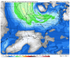
Loving this gfs run, ULL in position to bring in CAPE across the Carolinas Monday/Tuesday and maybe Wednesday, supporting multiple bouts of convection View attachment 41361View attachment 41362
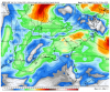
Anotha day ! View attachment 41363
The bottom image looks like it wants to fire up a good ole wedge boundary of some kind?


I like that look. Amazing that we're apparently going to work through the majority of May without any big heat so far this year. What a magnificent spring we have had!Euro gets this thing stuck now, ICON led the way, wow
View attachment 41368
I can't believe I'm still wearing a light hoodie to work here in Columbia SC loving this weather


Oh man. That's a recipe for big rain totalsNice, 3 days of convection
Oh man. That's a recipe for big rain totals
Would erase the deficit from the last 60-90 days. CMC is coming in with rainzilla as we speak.RIP Drought 2020
 over surprise morning fog that turns into cad during most of the day.
Those storms knocked down a giant sweet gum tree in my backyard if I’m not mistaken, I remember the shelf cloud with that, I think this was that time periodWas it August of '18 NC was sandwiched to the east of a trough and west of the ridge for like 2 weeks? It was just this beautiful stretch of afternoon storms, and with crazy high pwat values it was like turning buckets over instead of simple rain.