Snowflowxxl
Member
YesIs this from the Euro? Can't tell.. but can see cellular structure for sure.
YesIs this from the Euro? Can't tell.. but can see cellular structure for sure.
Yeah I'm seeing that in the newer model runs. If it keeps it up we definitely will avoid the worst of it up here.There is a bit of a wedge signature showing up, most models have it eventually going away as the event unfolds. We know they tend to over perform though so it will need to be watched. I'm off to bed, lots to watch next couple days.


That's not good.Trend on the GFS is for less influence of the wedge in GA
12z NAM keeps most of NC in the cooler side of things with a sharp boundary dividing the state.. meanwhile areas in GA, SC, AL and MS are in the low 70s so it could be rough down that way.
View attachment 16900
That is the key to watch, does this event trend higher with instability like the last one did. Higher instability, some sort of cap and an decent EML is the only thing keeping this from a High risk IMO.
What is this I hear about along the edge of a wedge, amplification of thunder storms in a setup like this? I'm not very good with severe, outside the basics... is it more prone to storm development, more shear, even with weaker severe ingredients?

Euro is slightly weaker with the PV and slightly west with the trough at 48hrs. Looks like the slowing/amping trend will continue.
Euro not backing down!
Edit: After looking at it in more depth, wow. Upped parameters for much of GA and Alabama.


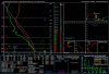
18z NAM has over 1000 j/kg cape values over S central MS into C AL Sunday afternoon. 0-1km SRH over 250 m2/s2 over AL...
STP increasing Sunday afternoon from previous runs.View attachment 16940
Also low level jet ramping up over AL/MS compared to 6z/12z valid 18z Sunday.
View attachment 16939
18z NAM has over 1000 j/kg cape values over S central MS into C AL Sunday afternoon. 0-1km SRH over 250 m2/s2 over AL...
STP increasing Sunday afternoon from previous runs.View attachment 16940
Also low level jet ramping up over AL/MS compared to 6z/12z valid 18z Sunday.
View attachment 16939
Chances of any 1 happening????Three things that could stop an outbreak.
1: too much junk convection slows warm front progression and instability stays too low.
2: Lack of EML contributes to #1 and poos laspe rates. Strong shear tears apart updrafts until front with wind being main threat.
3: SSW surface winds limit convergence and delay cell initiation. This allows upper level winds become parallel with the front and we end up with a squall line on the front.
Chances of any 1 happening????
Sent from my Pixel 2 using Tapatalk
Basically squall line..lol?Likely.
Basically squall line..lol?

Always does seem to be one thing that prevents everything from coming together for a system to reach its full potential. Most of the time it seem's a bunch of junk convection in the morning last longer than normal and doesn't allow for the atmosphere to destabilize. The warm front also doesn't make it as for north as the models had anticipated.
NWS has ATL at 63 Sunday. I’m all for 55 though.Last two events that were big in GA were 3/19/18 and 4/5/17. Both times saw the warm front really struggle to make it above the city. I will probably be monitoring that the closest from here on out. The GFS and ICON keep ATL around 55 most of the day, which would mean low chances.