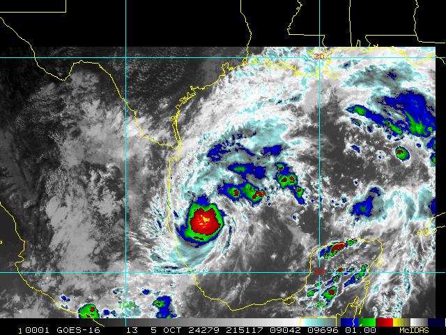
• Hello, please take a minute to check out our awesome content, contributed by the wonderful members of our community. We hope you'll add your own thoughts and opinions by making a free account!

Tropical Major Hurricane Milton

Crazy consistency with HWRF.

Someone correct me if I’m wrong, but all of the hurricane models are based off the GFS conditions right?
 
Outside of the short term movement, the movement to the NE on a dime is what will be super interesting. Could be a Sarasota or Tampa landfall IMO.
Nah.....it will "breeze by and push a s__t ton of water in the bay. But will be north of there. See hwrf.
 
Good bye Disneyworld! I have friends in the western Tampa area that I told yesterday to evacuate and advised them which areas of GA were not damaged by Helene per GA State Emergency Management.
 
Good bye Disneyworld! I have friends in the western Tampa area that I told yesterday to evacuate and advised them which areas of GA were not damaged by Helene per GA State Emergency Management.
Good job! It's a nutty decision to sit there and hope for the best.
 
I think it’s possible. All the short term models are busting right now except a few southerly ones. We shall see but heck I agree with you
I've seen hurricanes get drawn into a landfall on the Yucatan. At a minimum, it now seems Milton will be at least affected by proximity to the Yucatan.

This isn't to imply the southerly component to the track is currently being influenced by the land mass but rather pointing out an even further southward tug into a landfall is something to watch for once the storm gets north of the landmass.
 
Feels like this storm could get really wild with no secondary wind maxima yet. Wondering if we get up to 170-180mph today. Also worst case scenario is probably if the Yucatán effect disrupts and kicks off a quicker ERC… Florida doesn’t want time for a new larger eye to form and establish before it feels the effects of the trough and starts transitioning.

Ideal scenario would be the pinhole eye holds on as long as possible and then it collapses at the same time wind shear picks up and dry air starts gushing in.
 
10 mile wide eye...
105
URNT12 KWBC 071203
VORTEX DATA MESSAGE AL142024
A. 07/11:34:51Z
B. 21.78 deg N 092.23 deg W
C. NA
D. 949 mb
E. 005 deg 24 kt
F. CLOSED
G. C10
H. NA
I. NA
J. 223 deg 117 kt
K. 128 deg 7 nm 11:33:04Z
L. NA
M. NA
N. 028 deg 113 kt
O. 296 deg 8 nm 11:36:50Z
P. 15 C / 2454 m
Q. 21 C / 2434 m
R. 12 C / NA
S. 1234 / NA
T. 0.01 / 0.25 nm
U. NOAA3 0714A MILTON OB 11
MAX FL WIND 117 KT 128 / 7 NM 11:33:04Z
MAX FL TEMP 25 C 128 / 7 NM FROM FL CNTR
 
I think it's going to get to a cat 5 and hopefully weaken to a cat 4 before landfall. This is just the norm now for systems in the Gulf.
 
I think that area to the NE is interesting. I swear all of the rapid deepening/low pressure canes in recent years have had some form of that

I'm sure Web has an answer for that.


Sent from my iPhone using Tapatalk
 
I think that area to the NE is interesting. I swear all of the rapid deepening/low pressure canes in recent years have had some form of that


500x500.jpg


rbtop-animated.gif
 
Dang. Edit: I heard the SFMR is off though. But the flight level wind reduction supports high-end Cat 4.
799
URNT15 KNHC 071250
AF309 0814A MILTON HDOB 27 20241007
124200 2151N 09200W 6952 02815 9642 +103 +055 123096 101 109 008 00
124230 2149N 09201W 6970 02723 9544 +128 +051 119067 086 114 004 00
124300 2148N 09203W 6960 02686 9486 +136 +051 108041 058 079 002 00
124330 2146N 09204W 6970 02647 9453 +137 +055 092021 034 043 003 00
124400 2145N 09204W 6959 02642 9413 +160 +050 022004 017 023 002 00
124430 2143N 09204W 6970 02630 9410 +164 +055 293025 034 021 001 00
124500 2141N 09204W 6973 02637 9426 +163 +057 297062 081 074 005 00
124530 2139N 09205W 6977 02689 9518 +124 +079 296119 140 141 060 03
124600 2138N 09206W 6993 02726 9606 +101 +060 298143 146 141 061 00
124630 2137N 09207W 7018 02762 9696 +083 +052 301134 145 131 077 00
124700 2136N 09207W 6997 02835 9752 +084 +047 304121 125 105 071 00
124730 2135N 09208W 6953 02931 9793 +085 +049 309114 116 091 030 03
124800 2135N 09210W 6970 02949 9841 +082 +043 307105 115 085 021 00
124830 2134N 09211W 6959 02981 9839 +103 +041 304095 099 079 009 00
124900 2133N 09212W 6958 03004 9852 +113 +042 304089 094 074 004 00
124930 2131N 09213W 6964 03015 9886 +100 +041 305083 086 073 004 00
125000 2130N 09214W 6968 03026 9872 +127 +040 302082 083 068 004 00
125030 2129N 09215W 6960 03047 9891 +122 +040 302074 080 067 002 00
125100 2128N 09217W 6960 03058 9903 +121 +044 303071 073 067 003 00
125130 2127N 09218W 6959 03067 9906 +126 +043 302067 069 063 003 00
$$
 
Dang.
799
URNT15 KNHC 071250
AF309 0814A MILTON HDOB 27 20241007
124200 2151N 09200W 6952 02815 9642 +103 +055 123096 101 109 008 00
124230 2149N 09201W 6970 02723 9544 +128 +051 119067 086 114 004 00
124300 2148N 09203W 6960 02686 9486 +136 +051 108041 058 079 002 00
124330 2146N 09204W 6970 02647 9453 +137 +055 092021 034 043 003 00
124400 2145N 09204W 6959 02642 9413 +160 +050 022004 017 023 002 00
124430 2143N 09204W 6970 02630 9410 +164 +055 293025 034 021 001 00
124500 2141N 09204W 6973 02637 9426 +163 +057 297062 081 074 005 00
124530 2139N 09205W 6977 02689 9518 +124 +079 296119 140 141 060 03
124600 2138N 09206W 6993 02726 9606 +101 +060 298143 146 141 061 00
124630 2137N 09207W 7018 02762 9696 +083 +052 301134 145 131 077 00
124700 2136N 09207W 6997 02835 9752 +084 +047 304121 125 105 071 00
124730 2135N 09208W 6953 02931 9793 +085 +049 309114 116 091 030 03
124800 2135N 09210W 6970 02949 9841 +082 +043 307105 115 085 021 00
124830 2134N 09211W 6959 02981 9839 +103 +041 304095 099 079 009 00
124900 2133N 09212W 6958 03004 9852 +113 +042 304089 094 074 004 00
124930 2131N 09213W 6964 03015 9886 +100 +041 305083 086 073 004 00
125000 2130N 09214W 6968 03026 9872 +127 +040 302082 083 068 004 00
125030 2129N 09215W 6960 03047 9891 +122 +040 302074 080 067 002 00
125100 2128N 09217W 6960 03058 9903 +121 +044 303071 073 067 003 00
125130 2127N 09218W 6959 03067 9906 +126 +043 302067 069 063 003 00
$$

941 mb
 
Dang. Edit: I heard the SFMR is off though. But the flight level wind reduction supports high-end Cat 4.
...
124530 2139N 09205W 6977 02689 9518 +124 +079 296119 140 141 060 03
124600 2138N 09206W 6993 02726 9606 +101 +060 298143 146 141 061 00

Re: your Edit: Look at the end of the line. The 146 line doesn't throw a flag, but as an example, the line above it does.

Below is an example and key
1728306273836.png
1728306245315.png

So surface level winds

1728306424966.png
 
...MILTON RAPIDLY INTENSIFIES INTO A CATEGORY 4 HURRICANE...

Data from both Hurricane Hunter aircraft indicate that Milton has
strengthened to a category 4 hurricane. The maximum sustained
winds are estimated to be 150 mph (240 km/h). Milton is a category
4 hurricane on the Saffir-Simpson Hurricane Wind Scale. Data
from the aircraft also indicate that the minimum pressure has
fallen to 940 mb (27.76 inches).
High-end Cat 4.
 
Back
Top