ICON has some intense rain in NW piedmont of NC
-
Hello, please take a minute to check out our awesome content, contributed by the wonderful members of our community. We hope you'll add your own thoughts and opinions by making a free account!
You are using an out of date browser. It may not display this or other websites correctly.
You should upgrade or use an alternative browser.
You should upgrade or use an alternative browser.
Tropical Major Hurricane Michael
- Thread starter ForsythSnow
- Start date
EastAtlwx
Meteorologist
This isn’t really true.. because of friction you usually see the sustained winds verify as gusts on land.. so 135-145 gusts...If this is 135-145mph at landfall gusts will be 160-170 in some areas. This is going to make a run for category 4 today, unfortunately. I hope everyone in Panama City is evacuated because there will not be much left after the surge and wind moves through.
accu35
Member
Icon a touch west at LF
Blue_Ridge_Escarpment
Member
12k NAM, 3k NAM, RGEM all way further North at 12Z. Will the rest follow suit?
snowlover91
Member
Ocean front areas have no land to slow the winds down... so yes 160-170mph gusts are certainly possible in those areas if this is a cat 4.This isn’t really true.. because of friction you usually see the sustained winds verify as gusts on land.. so 135-145 gusts...
W
WeatherLC
Guest
Okay guys let’s not argue.
He is still fighting some dry air too, never under estimate the power of a little dry air in a TC (although it only is probably just delaying the inevitable)
snowlover91
Member
Latest visibles show the eye is clearing out more now, very ominous look.

snowlover91
Member
Yeah the dry air has really slowed the western side of this system down but it now appears the eyewall is closing back off based on latest recon. IR is also showing the convection really wrapping now and if that continues there really isn't much to weaken it until landfall. I'm seeing reports on twitter of the surge already flooding some areas with water rises of a few feet so far.He is still fighting some dry air too, never under estimate the power of a little dry air in a TC (although it only is probably just delaying the inevitable)
packfan98
Moderator
12z GFS is slight further NE at hr 33 compared to 6z.
accu35
Member
Michael still has west movement
packfan98
Moderator
Looks like Michael is moving a little faster on the 12z models so far.
Yep so far seems to be the trend, faster movement and why it gets much further north before being shunted eastLooks like Michael is moving a little faster on the 12z models so far.
Snowflowxxl
Member
Gfs is gonna be north this run
accu35
Member
Should we still follow the globle models at this point, or short range? Or nowcast?12z GFS is slight further NE at hr 33 compared to 6z.
packfan98
Moderator
We should use all available tools, but put more weight on some than others. Look for trends, use historical data, common sense, and go with a consensus of everything.Should we still follow the globle models at this point, or short range? Or nowcast?
One concerning thing I've noticed too, is even though the models are speeding up Michael initially, it's not rocketing out of here once inland like it once was. No Florence stall and crawl I know but any reduction in forward speed is problematic especially with the enhance precip on the NW side as noted previously
CMC almost exact same track as GFS
26.0N 85.6W 80 84 100/ 35/ 49 998.7
This buoy, which is just east of where the eye is headed, shows 84F or 29C SST, i.e., still bathwater/closer to norms of a month ago. It is this way all the way to the coast.
This buoy, which is just east of where the eye is headed, shows 84F or 29C SST, i.e., still bathwater/closer to norms of a month ago. It is this way all the way to the coast.
Last edited:
Post itHey @Tarheel1 check out the ICON. You got your bread, milk and plyboard?
F-5
Member
One request when discussing the model runs- many are saying so and so model is 50 miles ‘north’, ‘south’, ‘east’, ‘west’ and are referring to where Michael will pass through your back yard which may be 500-800 miles away from the actual landfall point.
Normally it is the landfall point we are discussing when we say a model is 45 miles east or west so please take note to reference what geographic area you are looking at when you say such and such model is coming in so and so of the previous run.
Normally it is the landfall point we are discussing when we say a model is 45 miles east or west so please take note to reference what geographic area you are looking at when you say such and such model is coming in so and so of the previous run.

Post it
accu35
Member
We just say it as we see itOne request when discussing the model runs- many are saying so and so model is 50 miles ‘north’, ‘south’, ‘east’, ‘west’ and are referring to where Michael will pass through your back yard which may be 500-800 miles away from the actual landfall point.
Normally it is the landfall point we are discussing when we say a model is 45 miles east or west so please take note to reference what geographic area you are looking at when you say such and such model is coming in so and so of the previous run.
ForsythSnow
Moderator
When we say a model is "north" typically it is referring to the previous run. For instance, the 12Z ICON was north of the 6Z icon. It has nothing to do with back yard posts.One request when discussing the model runs- many are saying so and so model is 50 miles ‘north’, ‘south’, ‘east’, ‘west’ and are referring to where Michael will pass through your back yard which may be 500-800 miles away from the actual landfall point.
Normally it is the landfall point we are discussing when we say a model is 45 miles east or west so please take note to reference what geographic area you are looking at when you say such and such model is coming in so and so of the previous run.
accu35
Member
Last couple of frames Michael has wobble little more west, or maybe I'm just seeing things
When’s the cvs3-GFS run again?
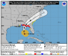
Did anybody post the 11 AM NHC updated track?? I saw it on local news, it looks N of last advisory!?
GeorgiaGirl
Member
When’s the cvs3-GFS run again?
It has started. Some of the data is missing but the 36 HR point looks north of the GFS.
Here’s the latest:Did anybody post the 11 AM NHC updated track?? I saw it on local news, it looks N of last advisory!?
Attachments
When’s the cvs3-GFS run again?
Now, Mack. Hour 12 of 12Z FV3 nearly identical to 6Z FV3 hour 18.
ForsythSnow
Moderator
Its started to run. It's also the FV3.When’s the cvs3-GFS run again?
It moved a hair north. I compared the interactive maps between advisory 12 and 11 and it went north about 10 miles.Did anybody post the 11 AM NHC updated track?? I saw it on local news, it looks N of last advisory!?
accu35
Member
Michael is moving, at a NNW motion, wonder if places west of PC like Destin could get a direct hit as the CMC is showing? Idk, just bored and on vacation
Not much if any change with the FV3 from it's previous run
NHC track actually gets it just west of due south of Destin before the bend back NNE... it looks on track to meMichael is moving, at a NNW motion, wonder if places west of PC like Destin could get a direct hit as the CMC is showing? Idk, just bored and on vacation
Was it still one of the farther N and W runs, like it’s been the last few days?Not much if any change with the FV3 from it's previous run
Looks like it yes but not crazy off from the rest... it hasn't finished loading all frames so can't post a pic yet.Was it still one of the farther N and W runs, like it’s been the last few days?
W
WeatherLC
Guest
Headed to pcb now
Was it still one of the farther N and W runs, like it’s been the last few days?
Not anymore. It is now near the consensus and much slower. Just 5 runs ago it was near Atlanta as of 8PM EDT tomorrow. Now it is near where AL, FL, and GA come together at 8PM tomorrow! I know the CMC has struggled. But the FV3 hasn’t done well either.
W
WeatherLC
Guest
You guys want me to post live?