GeorgiaGirl
Member
Euro seems like it's going to make landfall at or below 950mb. 

Yea has it down to 940 at hour 30 and 947 at hour 36 after landfall. Wow.Euro way stronger this run.

.png")
Euro is 940mb at landfall. Strongest Euro run yet I believe.
It had 935mb for one run a day or so ago.
Ah thanks I must have missed that one. This could hit the 930s if it deepens like the Euro is showing... a scary thought for those along the FL panhandle. I sure hope everyone has evacuated and taken necessary precautions.

Euro actually gets down to 934 before landfall.
Yep, still off shore as well. That may have been headed for 930mb or so.


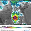
This storm looks to be Cat 3 already based on wind speeds and satellite presentation!!
A fairly widespread area of 5-7" in areas that really don't need it is looking more and more likely. Fortunately there hasn't been much rain since Florence
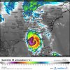
Not good... it's about to explodeSaw this . Lightening in the EW now.

Honestly the Euro may not be strong enough... in a storm that has an environment for RI and deep convection like this they often get even stronger than modeled. Sub 930mb is not out of the realm of possibility here.Even if the Euro is overdone, that’s still a scary signal given its current appearance and the convective energy it has to work with tonight.
Tomorrow afternoonWhat time is landfall looking like
Sent from my iPhone using Tapatalk
Honestly the Euro may not be strong enough... in a storm that has an environment for RI and deep convection like this they often get even stronger than modeled. Sub 930mb is not out of the realm of possibility here.
Where do you find the best track info (I think Eric shared it one day but I can't find it)18z best track up to 115mph, 960mb pressure so a major coming at 5pm today.
But weakened as it approached landfall, which hopefully Michael will do as well..... but good reference pointFor reference, Opal got down 916mb
NW jump?Saw this . Lightening in the EW now.
I actually don't have a link for it, I usually just pull it from another board that I use for tropical weather and usually someone there posts it as soon as it goes live.Where do you find the best track info (I think Eric shared it one day but I can't find it)
Found this on the NCAR site..... if correct that's 120 mph??I actually don't have a link for it, I usually just pull it from another board that I use for tropical weather and usually someone there posts it as soon as it goes live.
Yep that's it! I calculated the knots wrong, so it would be 120mph at 5pm.Found this on the NCAR site..... if correct that's 120 mph??
At 1800 UTC, 09 October 2018, MAJOR HURRICANE MICHAEL (AL14) was located in the North Atlantic basin at 25.5°N and 86.4°W. The current intensity was 105 kt and the center was moving at 10 kt at a bearing of 340 degrees. The minimum central pressure was 960 mb.
Dang and to think it hasn't yet realized it's full potential, this is getting criticalYep that's it! I calculated the knots wrong, so it would be 120mph at 5pm.
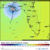
It does look that way .landfall looks a bit west too?The 12Z Euro is a little NW of its prior run.
Yeah these overshooting tops are -80C and some have approached -90C. The landfall areas are going to see tremendous surge and winds from this and Euro intensity seems on track and might not be strong enough. Sub 930mb is definitely possible here and cat 5, although unlikely, is possible. The only thing really that could slow this down is if an EWRC manages to start before landfall.Dang and to think it hasn't yet realized it's full potential, this is getting critical