-
Hello, please take a minute to check out our awesome content, contributed by the wonderful members of our community. We hope you'll add your own thoughts and opinions by making a free account!
You are using an out of date browser. It may not display this or other websites correctly.
You should upgrade or use an alternative browser.
You should upgrade or use an alternative browser.
Tropical Major Hurricane Michael
- Thread starter ForsythSnow
- Start date
I can't believe those temps are still cooling. I've got chills looking at this. I read on AmericanWx that Brett Adair is right in front of this thing. He better find somewhere quickly.
Webberweather53
Meteorologist
Looks like we still have at least 2 perhaps 3 mesovorts left in the eyewall that have yet to fully consolidate. Once those merge, expect the minimum central pressure in Michael to fall again as I explained in my some of my earlier comments/tweets. We have a little gas left in the tank
Mason Dixon
Member
The turn to go nw up Cape San Blas, we stayed here in August, wonder how much will be leftYeah this thing is still strengthening. Can you imagine if you were in Port St Joe right now..Grief..the LF aftermath is going to rival Sullivan’s Island and IOP when Hugo hit with extreme damage inland
DadOfJax
Member
I can't believe those temps are still cooling. I've got chills looking at this. I read on AmericanWx that Brett Adair is right in front of this thing. He better find somewhere quickly.
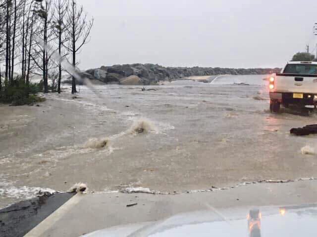
Brett is in Port St. Joe....honestly the best possible place along the coast. It has a long barrier island in front that will minimize the surge. Winds will still be insane...but not much risk of flooding.
W
WeatherLC
Guest
I’m right there too. Just north of Mexico beach in WewahitchkaI can't believe those temps are still cooling. I've got chills looking at this. I read on AmericanWx that Brett Adair is right in front of this thing. He better find somewhere quickly.
ALHammerWx
Member
- Joined
- Jan 4, 2017
- Messages
- 61
- Reaction score
- 117
If you want to follow probably the best cyclone chaser out there follow this guy. It's almost a guarantee he will get in the worst of the eye wall.
https://twitter.com/iCyclone[/QU
Will he go to live video feed on Twitter, FB or Periscope?
I’m right there too. Just north of Mexico beach in Wewahitchka
Sheash man. Be safe.
DadOfJax
Member
Got a link to your stream?I’m right there too. Just north of Mexico beach in Wewahitchka
So it looks like you're a little inland which is good.I’m right there too. Just north of Mexico beach in Wewahitchka
Brent
Member
I can't believe those temps are still cooling. I've got chills looking at this. I read on AmericanWx that Brett Adair is right in front of this thing. He better find somewhere quickly.
said he was going to search Mexico Beach for something that can survive
Not sure that exists
The last time I went to FL i stayed at a motel in Mexico Beach. I'm afraid there won't be much left in that small town.
DadOfJax
Member
said he was going to search Mexico Beach for something that can survive
Not sure that exists
Brett is in Port St. Joe, and by his stream, you can see what the barrier island is doing to help with surge....well played Brett.
snowlover91
Member

snowlover91
Member
In one pass the VDM pressure went from 929 to 925. I'm expecting this one to be around 922 or so based on continuing improvements to the structure.
In one pass the VDM pressure went from 929 to 925. I'm expecting this one to be around 922 or so based on continuing improvements to the structure.
I sound like a broken record, tops still cooling.
RealtorWeatherGirlGA
Member
Still sitting at 923mb but has picked up a little speed at 14mph previously been at 12mph. 50 miles SSW of PCB last report I read.
ALHammerWx
Member
- Joined
- Jan 4, 2017
- Messages
- 61
- Reaction score
- 117
Does anyone have a url to a live webcam in PCB? I have searched several and cannot get on any I have found.
live video streams?? this is just horrifying
snowlover91
Member
Radar now picking up 190mph winds roughly 5-6k feet above the ground.
NoSnowJoe
Member
Link please...tiaBrett is in Port St. Joe, and by his stream, you can see what the barrier island is doing to help with surge....well played Brett.
Amazing so close to PCB and yet the winds in PCB don't seem strong at all. I wonder if this could be like Andrew where the winds were so strong near the eyewall but not far away the winds weren't bad at all.Still sitting at 923mb but has picked up a little speed at 14mph previously been at 12mph. 50 miles SSW of PCB last report I read.
W
WeatherLC
Guest
Yeah was worried about surge. Still under an extreme wind warningSo it looks like you're a little inland which is good.
Last nights HMON nailed this thing yet may still be slightly too high on pressure. I think it was ~922-925 with surface winds just above 135knts.
DadOfJax
Member
Live Chasing AppLink please...tia
wannabwm
Member
https://livestormchasing.com/Link please...tia
Amazing so close to PCB and yet the winds in PCB don't seem strong at all. I wonder if this could be like Andrew where the winds were so strong near the eyewall but not far away the winds weren't bad at all.
Sent from my SM-G920V using Tapatalk
Still a good bit of lightning in the eyewall...
Sam Sparks
Member
live video streams?? this is just horrifying
Pineapple Willys has their live stream going on Facebook
Brent
Member
Last nights HMON nailed this thing yet may still be slightly too high on pressure. I think it was ~922-925 with surface winds just above 135knts.
and people think the HMON is crazy...
We have 155 guest online right at this moment. Please take a minute of your time so you can sign up and enjoy the full benefits of the website. It’s completely free and you can join the conversation.
Last edited:
NE pass incoming. This may be the last.

snowlover91
Member
The eyewall is full of lightning... incredible.
Webberweather53
Meteorologist
This pass should be telling. We've nearly sheared off the last remaining mesovort that was left in the eye, which argues for another pressure fall, might be enough to get us to a cat 5.
Brent
Member
918.3
ForsythSnow
Moderator
Cat 5 flight level winds on NE and SW quadrants.