Yellow Snow
Member
The surf in Pensacola is insane...


At some point today Rah has to consider expanding their wind advisories imo...Parts of the triangle would be on the eastern side of the storm with this track.
View attachment 6905
NAM has ton of rain right through East ATL
NAM has ton of rain right through East ATL
For NC folks and just to add to this, the NAM has pressure falling as it crosses the state, baroclinic enhancement no doubt and could be a decent wind issueAt some point today Rah has to consider expanding their wind advisories imo...
You can say that again.I’ve never seen an eye like that on radar.
Sent from my iPhone using Tapatalk
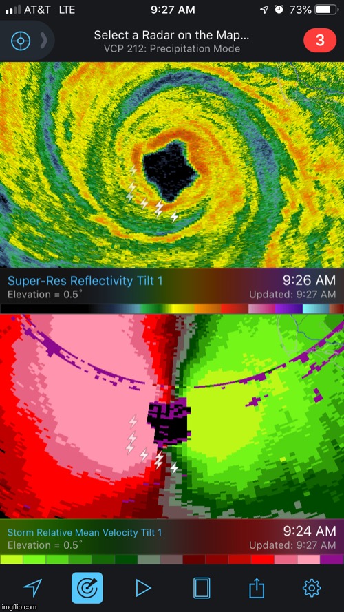
You can say that again.
For NC folks and just to add to this, the NAM has pressure falling as it crosses the state, baroclinic enhancement no doubt and could be a decent wind issue
My biggest fear has come true!!! NAM send it further south below the FL line to people who have no clue! This will be catastrophic on many fronts!!!Even the usually over intensifying 3K NAM never gets Michael below 955 mb.... and looks like pressure down to 925 mb, holy crap
We cover the entire SE and don't break the threads down by states, so, many will post about NC/SC/Ga/Al and of course Fl. No one is diminishing the historic event that is unfolding but if we limited it to only that then most everyone on here would go to all the other micro threads and we don't want that either. Hope you understand... thanksThis may come off the wrong way from a very infrequent poster, but is there a way to have a separate thread for the impacts to the Carolinas? I get that you all may be hammered as well, but the constant posts on what may happen in SC/NC really takes away from the history that is about to unfold in the Florida Panhandle
 With only this distance to landfall, not going to weaken, not gonna do it!
We cover the entire SE and don't break the threads down by states, so, many will post about NC/SC/Ga/Al and of course Fl. No one is diminishing the historic event that is unfolding but if we limited it to only that then most everyone on here would go to all the other micro threads and we don't want that either. Hope you understand... thanks
000
WTNT44 KNHC 101450
TCDAT4
Hurricane Michael Discussion Number 16
NWS National Hurricane Center Miami FL AL142018
1000 AM CDT Wed Oct 10 2018
Michael is an extremely impressive hurricane in visible and infrared
satellite imagery this morning. The eye has continued to warm and
become even more distinct, while remaining embedded within an area
of very cold cloud tops. Data from NOAA and U.S. Air Force Hurricane
Hunter aircraft indicate that the pressure has continued to fall
this morning and is now around 928 mb. Flight-level, SFMR, and NWS
WSR-88D Doppler wind data all support an intensity of 125 kt. The
hurricane only has a few hours left over water during which
additional intensification is possible. Recent radar imagery
suggest that an outer eyewall may be trying to form, and this could
slow or halt the intensification process. Although steady weakening
is predicted once the hurricane moves inland, the core of Michael
will bring hurricane-force winds well inland over the Florida
Panhandle, southeastern Alabama, and southwest Georgia. As the
circulation emerges over the western Atlantic, intensification due
to baroclinic process is expected, and Michael should complete its
transition to an extratropical low by 48 hours when it is off the
U.S. Mid-Atlantic coast. The system is predicted to remain a
powerful extratropical cyclone over the north Atlantic through at
least day 4.
Aircraft and radar fixes show that Michael has made its much
anticipated north-northeastward turn, and the hurricane is expected
to make landfall along the coast of the Florida Panhandle early this
afternoon. Michael should turn northeastward and begin to accelerate
as it becomes embedded within the mid-latitude flow while moving
across the southeast U.S. through Thursday night. The cyclone is
forecast to emerge over the western Atlantic on Friday, and move
rapidly eastward-northeastward across the north Atlantic this
weekend. The track guidance remains in excellent agreement, and the
updated NHC track forecast is very close to the previous advisory.
Tropical storm warnings have been extended northward along the U.S.
East Coast to Duck, North Carolina. Non-tropical watches, warnings,
and advisories will be issued by local NWS offices for wind hazards
north of Duck, North Carolina, as Michael is expected to be
post-tropical when it affects those areas.
Key Messages:
1. Life-threatening storm surge is occurring along portions of the
Florida Panhandle, Big Bend, and Nature Coast. The worst storm surge
is expected later today and tonight between Tyndall Air Force Base
and Keaton Beach, where 9 to 14 feet of inundation is possible.
2. Michael will produce potentially catastrophic wind damage
where the core of the hurricane moves onshore later today in the
Florida Panhandle, with the highest risk between Apalachicola and
Panama City.
3. Life-threatening hurricane-force winds will occur well inland
across portions of the Florida Panhandle, southeast Alabama, and
southwestern Georgia as the core of the hurricane moves inland
later today and this evening.
4. Heavy rainfall from Michael could produce life-threatening flash
flooding from the Florida Panhandle and Big Bend region into
portions of Georgia, the Carolinas, and southeast Virginia.
5. Tropical storm conditions will affect portions of the southeast
U.S. coast from northeast Florida through North Carolina, and
tropical storm warnings are in effect for these areas.
FORECAST POSITIONS AND MAX WINDS
INIT 10/1500Z 29.4N 86.0W 125 KT 145 MPH
12H 11/0000Z 31.3N 84.7W 85 KT 100 MPH...INLAND
24H 11/1200Z 33.6N 82.1W 40 KT 45 MPH...INLAND
36H 12/0000Z 35.8N 78.0W 45 KT 50 MPH...INLAND
48H 12/1200Z 38.7N 71.6W 55 KT 65 MPH...POST-TROP/EXTRATROP
72H 13/1200Z 45.5N 52.5W 60 KT 70 MPH...POST-TROP/EXTRATROP
96H 14/1200Z 49.0N 29.0W 60 KT 70 MPH...POST-TROP/EXTRATROP
120H 15/1200Z 50.0N 13.0W 35 KT 40 MPH...POST-TROP/EXTRATROP
With Hurricane Andrew being a Cat 5 with 922mb pressure, could Michael be off the coast just long enough for the wonds to catch up the drop in pressure? A high Cat 4 or possibly, fence-line Cat 5.
It has to get up to 156 mph on wind speed for it to be considered a cat 5. It’s going to be close on this one.With Hurricane Andrew being a Cat 5 with 922mb pressure, could Michael be off the coast just long enough for the winds to catch up to the drop in pressure? A high Cat 4 or possibly, fence-line Cat 5.
Evacuation efforts locally were underwhelming. The bulk of the local residency base evacuation need against the Opal high water level. We left yesterday afternoon, and it was the easiest evacuation ever....which is extremely disheartening. The vast majority of our family elected to stay...think the want to be there in the immediate aftermath outweighed the safety of heading elsewhere but then being denied access into Bay County.Those who stayed need prayers for a brain. Maybe God will grant them one if they survive.

Yeah, the east wobbles have been winning out lately although it almost looks like a slight wobble back north atm.... either way it may pass just east of them. Like you say going to be very close call.Lightning all around the south/southeast sides of the eye still. With FL winds of 144kts in the SE quad this is no doubt a solid 145mph cat 4. It's going to be a close call from Panama City and any wobbles will determine if they get on the east or west side of the eyewall.
