Xtreme Weather
Member
TY I knew I wasn't going cross eyedI made a track map with the radar and NHC track, you can see how Irma has even passed west of advisory #43A:
Good to see you
TY I knew I wasn't going cross eyedI made a track map with the radar and NHC track, you can see how Irma has even passed west of advisory #43A:
No I didnt evacuate. Not worried about where I live.Did you evacuate, or just have another reason to go to TN?
Best of luck with the interview!No I didnt evacuate. Not worried about where I live.
")
Thank you !Best of luck with the interview!
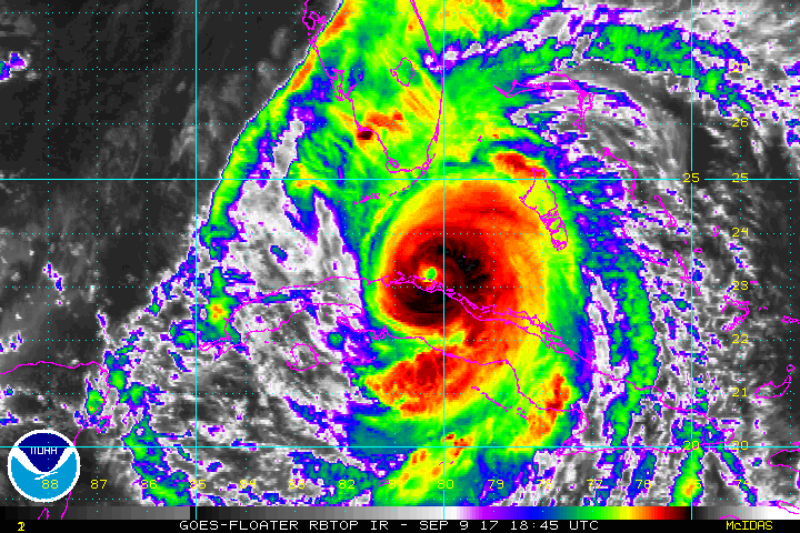
plus west wobblecloud top inbound
far, far from it ...and dont think she is done
precisely ...Gaining latitude, the turn is here
Sent from my SM-J320VPP using Tapatalk
QuestionableAt least it's in the ballpark of reality tonight
Sent from my SM-J320VPP using Tapatalk
Lol the one that's been leading the way?At least it was right at hour 00. More than could be said of a certain model at 12Z by a wide margin
That's saying a lot if it's leading the way and cant even get initiation correct. SmhLol the one that's been leading the way?
Sent from my SM-J320VPP using Tapatalk
Lol it's clearly led the way . But good for the NAM to initialize in the right spot . Least it's not headed to OBX tonightThat's saying a lot if it's leading the way and cant even get initiation correct. Smh
Maybe it's better at 48-72 than 00? LolLol it's clearly led the way . But good for the NAM to initialize in the right spot . Least it's not headed to OBX tonight
Sent from my SM-J320VPP using Tapatalk
Statistics speak for themselvesMaybe it's better at 48-72 than 00? Lol
yes - and so do live people - and that's a concern ...Statistics speak for themselves
Sent from my SM-J320VPP using Tapatalk
ewww... sick NAM Burn hahaLol it's clearly led the way . But good for the NAM to initialize in the right spot . Least it's not headed to OBX tonight
Sent from my SM-J320VPP using Tapatalk
Here's your ribbon -They all have sucked with this storm. It's just a matter of who has sucked the least. I think they all deserve a participation ribbon though.


To be fare to the silicon gods consensus wise they've been pretty good inside 96 hours once they got over their typical east biased out in the Atlantic. I could care less which one is the winner because its always carbon based entity's that lose in the end. Sorry, banter it.They all have sucked with this storm. It's just a matter of who has sucked the least. I think they all deserve a participation ribbon though.
933 per discodown to prob 930-931mb now
Because, part one was starting to have too many pages which could have caused issues with the board.Sorry if this has already been asked, but why the need for a Part 2 thread?
new drop was 932mb with a little sfc wind933 per disco
I am shocked the NHC only increases this 5 mph really? Looks 100x better than this morning and yet they have next to no strengthening???
