gawxnative
Member
Precip field in edging North also

nice visible, but juxtapose that with upper dynamics to get a real idea -- old fashioned eye-ball weather at his point ...last few frames, West

soon you can add a 0 to that ...80,000 already without power in Florida
Sent from my SM-J320VPP using Tapatalk
last few frames, West
Great points. You can see that that Irma is pushing the upper flow out ahead of her to a favorable position.With the trough approaching there should be an added bit of enhancement grim divergence and maybe outflow to the north before shear becomes detrimental
Sent from my SM-G955U using Tapatalk
Yeah there is a pretty clear jog NNW. I think your spot onThat loop is outdated as it ended nearly 2 hours ago. Actually, it now looks like it may be commencing to make that track change to NNW. We should know for sure within the next couple of hours.
Larry - there are only 2 directions - due north as all suspect, or some sort of dive underneath (which ain't gonna happen, but it still might/could). Bottom line - Hogtown Creek is gonna swell and there will be lots of trees down in this neck of the woods. I'll try to get to Veterans if roads are OK on Monday evening and get you a pic!That loop is outdated as it ended nearly 2 hours ago. Actually, it now looks like it may be commencing to make that track change to NNW. We should know for sure within the next couple of hours.
Lift-off in 3,2,1....Becoming much more symmetrical as well

Creeping along as the steering flow briefly breaks down. At one point I thought this might happen in the BahamasNot moved this marker in about 1.5 hours
Moving WNW

Yup erc coming to a close it appears moved tracker about 90 miles SE of Key W nowThe inner core of Irma is damn impressive
Sent from my SM-G955U using Tapatalk
Yes it isThe inner core of Irma is damn impressive
Sent from my SM-G955U using Tapatalk
Yup erc coming to a close it appears
At least it's in the ballpark of reality tonight0z nam goes hard north, NE of 18z.
Sent from my SM-G955U using Tapatalk
Wonder if the Key West radar will make it through a direct hit
Don't drink the koolaid LoL0z nam goes hard north, NE of 18z.
Sent from my SM-G955U using Tapatalk
Just got to my hotel in Kingsport, TN. Wow, almost every single hotel in TN is booked up. Thought I would never find one.

Did you evacuate, or just have another reason to go to TN?Just got to my hotel in Kingsport, TN. Wow, almost every single hotel in TN is booked up. Thought I would never find one.
On my way to Virginia for a job interview. Stopped here cause got tired driving. This hotel has 400 channels but doesn't carry TWC !Why did you go to TN?
Sent from my iPhone using Tapatalk
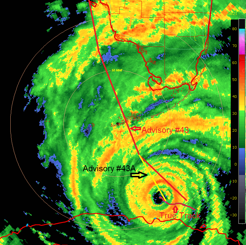
By the "Like", I mean you're spot on. I don't necessarily like the more westerly track into the bathtub aka the GOM.I made a track map with the radar and NHC track, you can see how Irma has even passed west of advisory #43A:

At least it's in the ballpark of reality tonight
Sent from my SM-J320VPP using Tapatalk
