WCDawson
Member
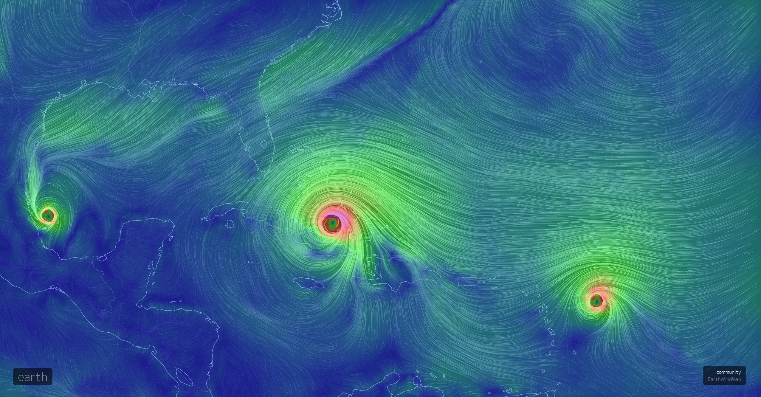
Is it just me or is the eye looking pretty ragged right now? Is that due to the EWRC, or is it the close proximity of Cuba?
I know tons of people that live in Orlando they all say most people are stayingFlorida gov. Rick Scott " All Floridians(over 20 million) should be prepared to evacuate soon"

Wow!!Dang lol
That is f^&%ing asinine!Florida gov. Rick Scott " All Floridians(over 20 million) should be prepared to evacuate soon"

I know tons of people that live in Orlando they all say most people are staying
Sent from my SM-J320VPP using Tapatalk
Dang, my hasn't load up yetWow some eps members go deep into Cuba
Sent from my SM-J320VPP using Tapatalk


Very bad for a lot and Orlando!Some stay offshore till about tampa . Others more central floriDA
Sent from my SM-J320VPP using Tapatalk
Gives it littke more time over waters if that would verifySome stay offshore till about tampa . Others more central floriDA
Sent from my SM-J320VPP using Tapatalk


Be safe Phil. Hope you have all your family with you so you don't have to worry about them.Reporting in from the southern flank ...
Gainesville is a parking lot; evacuees everywhere looking for gas;
Projected winds (not gusts) at 100mph;
Projected 'Cane conditions from after dark Sunday until mid-morning Monday, with TS conditions on either side for hours.
Until it gets unsafe or power/internet goes out, I'll toss in an update when appropriate.
Take care and
Best,
Phil
Son is riding it out in Temple Terrace, but that's a pretty safe area and he has friends whose parents have gated community houses 10 minutes away to head to if he feels like there is a need. She who keeps me sane and I are fine and thanks!Be safe Phil. Hope you have all your family with you so you don't have to worry about them.
Someone tell me how the hell that's going to happenFlorida gov. Rick Scott " All Floridians(over 20 million) should be prepared to evacuate soon"
Yes, please do stay safe Phil, and everyone who is in the path of the storm, even to the guests here, and everyone in the possible wind areas too. I am expecting power loss Monday sometime, but I expect to have it up within a day due to being on an emergency center line. Hopefully everyone is prepared in case it heads their way.Be safe Phil. Hope you have all your family with you so you don't have to worry about them.
Especially since it appears they have very little gas in the entire peninsula. What a nightmare to have a bunch of folks stuck in traffic during hurricane conditions.Someone tell me how the hell that's going to happen
Especially since it appears they have very little gas in the entire peninsula. What a nightmare to have a bunch of folks stuck in traffic during hurricane conditions.
Chaos is an understatement, folks --- and I'm in N FL ...Actually have a friend in Naples, Fl that was panicking and going to be stuck due to there not being any gas. He had a tank and all the hotels within distance of that amount of gas were booked up. Luckily, he found a safe place to go. I can't imagine what these people are dealing with though with trying to get out and gas being scarce. From what he said, it's really chaotic down there.
My aunt drove here from West Palm on Wednesday and it was already bad with gas running out. Can't imagine if someone waited last minute. Do they have a plan to help stranded motorists?Chaos is an understatement, folks --- and I'm in N FL ...
This is a glorified cluster unfolding (and some of it is self-inflicted by folks who are either clueless or deniers).
The Governor is doing all he can, but at some point, personal responsibility has to come into play ...My aunt drove here from West Palm on Wednesday and it was already bad with gas running out. Can't imagine if someone waited last minute. Do they have a plan to help stranded motorists?
Chaos is an understatement, folks --- and I'm in N FL ...
This is a glorified cluster unfolding (and some of it is self-inflicted by folks who are either clueless or deniers).
No doubt. Never wise to wait last minute on a storm like this. Hoping for the west trend into Cuba. The radar is picking up some good outer bands now.The Governor is doing all he can, but at some point, personal responsibility has to come into play ...