Lick beach Florida lolI’m coming with, where we goin ?
-
Hello, please take a minute to check out our awesome content, contributed by the wonderful members of our community. We hope you'll add your own thoughts and opinions by making a free account!
You are using an out of date browser. It may not display this or other websites correctly.
You should upgrade or use an alternative browser.
You should upgrade or use an alternative browser.
Tropical Major Hurricane Helene
- Thread starter SD
- Start date
- Status
- Not open for further replies.
Henry2326
Member
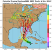
I don't know. They really like TVCN and it's still running up the border.Cone will come West at 5 pm if this is correct. View attachment 151532
NoSnowATL
Member
Windshield wiper effectI don't know. They really like TVCN and it's still running up the border.
Triplephase93
Member
1
NWMSGuy
Member
#2 let's go
Ron Burgundy
Member
So a likely major in the middle of the gulf at 72 and then at the GA/TN line at 96? That’s going to be an action-packed 24 hours around here if that verifies
Drizzle Snizzle
Member
Is it possible the impacts in GA could rival Opal ?
SnowwxAtl
Member
Surpass Opal impact...
Drizzle Snizzle
Member
I was out of power for a week with Opal !Surpass Opal impact...
Ron Burgundy
Member
Afternoon disco from FFC. Kind of a jarring lead in…
.LONG TERM...
(Wednesday morning through next Sunday)
Issued at 302 PM EDT Mon Sep 23 2024
At a glance:
-Something wicked this way comes...
-Long term forecast will be dominated by what Potential Tropical
Cyclone Nine does.
ALL INTERESTED PARTIES SHOULD CONTINUE TO MONITOR THE LATEST
UPDATES FROM THE NATIONAL HURRICANE CENTER REGARDING POTENTIAL
TROPICAL CYCLONE NINE
Nothing about what is setting up in the Gulf is something we
typically like to see for this time of year. As of writing this, the
National Hurricane Center has started making headlines for Potential
Tropical Storm nine which is currently lurking just off the Yucatan
Peninsula. Given the track of the storm and the hot tub that is the
gulf of Mexico, the Hurricane center is already confident that this
storm will likely become a Hurricane by Wednesday.
The long term forecast picks up on Wednesday afternoon. It leads off
with a weak low pressure out of the northwest that is dissipating
and is set to leave a stationary front over the northern part of the
CWA. Currently the NHC is tracking the storm to make landfall
sometime late on Thursday and push through the CWA during the early
morning on Friday and through the day. After that, it`s interaction
with the stationary front will be the big question. The NHC has the
track of the storm heading off the the northwest, keeping it in our
CWA for nearly it`s entire lifetime.
The problem now, is that the forecast is subject to change pretty
drastically over the next couple of days. QPF and wind field will
largely depend on how nasty this thing wants to become. As of right
now the WPC has widespread 3 inches across the entire state. This is
a respectable first guess as a base of what`s to come. The storm
itself will likely drop significantly more in isolated areas where
the heavies bands set up. As far as the wind field goes, widespread
wind gusts exceeding 35 mph are expected to begin Thursday afternoon
across all of the CWA although those gusts will likely arrive
Thursday morning across portions of the southern part of the CWA.
The TC tornado threat will largely depend on the track of the storm.
It will be greatest if the eye tracks further to the west. We`ll be
keeping an eye on any subtle shifts in the track to get a better
idea of where that front right quadrant is most likely to make
landfall.
It’s not coming that west. If anything this will be more East the closer we get. It will still curve NW eventually but not that much.Cone will come West at 5 pm if this is correct. View attachment 151532
Ron Burgundy
Member
Based on…?It’s not coming that west. If anything this will be more East the closer we get. It will still curve NW eventually but not that much.
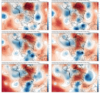
A few things that I would like to note here:
- High Pressure Ridge to the East: To the east of the storm (over the Atlantic Ocean), there is a strong ridge of high pressure (shown in red and orange hues), indicating higher geopotential heights. This ridge is likely blocking the storm's ability to move eastward and forcing it to track northward or slightly westward.
- Trough in the Central U.S.: There is a pronounced trough over the central U.S., dipping down towards the Gulf of Mexico. The cyclonic flow around this trough would act to pull the storm northward, guiding it in that direction and potentially curving its track towards the northeast as it approaches the southeastern U.S.
- Interaction with the Jet Stream: The jet stream, as represented by the 500mb level contours and wind flows, likely interacts with the storm. The trough to the north and west might deepen, which would steer the storm in a more northerly or northeasterly direction as it encounters stronger mid-latitude westerlies.
- Intensity of the Ridge: The strength of the high-pressure ridge to the storm's east will determine how much the storm is suppressed westward versus being allowed to turn north. If the ridge weakens, the storm may more easily make a turn to the northeast, but if it remains strong, the storm could be funneled into the eastern Gulf of Mexico before curving
That’s just what it always does. It never fails.Based on…?
Ron Burgundy
Member
Thanks. I’m sold.That’s just what it always does. It never fails.
ForsythSnow
Moderator
I'm going by the OFCI which is the NHC track, so if they go W, it's almost certain that's the new cone at 5.It’s not coming that west. If anything this will be more East the closer we get. It will still curve NW eventually but not that much.
ForsythSnow
Moderator
Nerman
Member
I know Levi said he's hesitant it could get stacked that quickly but I don't see anything that could stop it over next 24 hours.We will know tonight if they are correct.
Sheer?I know Levi said he's hesitant it could get stacked that quickly but I don't see anything that could stop it over next 24 hours.
Nerman
Member
There really isn't much sheer or dry air around it. We'll see...Sheer?
Last edited:
The sheer that is around is actually going to help it
Sheer?
Mahomeless
Member
Landfall is tonight?We will know tonight if they are correct.
Mahomeless
Member
WishcastingBased on…?
NoSnowATL
Member
No. Maybe a true center to followLandfall is tonight?
Nerman
Member
NoSnowATL
Member
lots of dry air in the GOM but should lessen soon.There really isn't much sheer or dry air at all around it. We'll see...
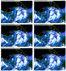
Definitely has that look to it. Looking at the outflow, this might end up with a fairly large wind fieldView attachment 151538
It's taking shape
Mahomeless
Member
Guess I'm missing how that translates if a model is going to be right on landfall pressure...No. Maybe a true center to follow
ForsythSnow
Moderator
Convection is starting to race over the LLC now, so it's not wasting time trying to stack itself. Whether it keeps up or not is to be seen, but it already has some intensity in the eastern end so it won't take much to get it off the ground once it wraps up.
NoSnowATL
Member
its called Analysis. We can go back on the models and see if they are correct on location, strength etc... Its how weather is understood. Doesn't mean its right but we can at least see if it initiated correctly.Guess I'm missing how that translates if a model is going to be right on landfall pressure...
Last edited:
Blue_Ridge_Escarpment
Member
I don’t think so. The 18Z suite is further east than the 12ZCone will come West at 5 pm if this is correct. View attachment 151532
ForsythSnow
Moderator
The cone was too far east compared to other modeling, so the NHC will be adjusting which is why OFCI is pathed through the core of the models vs the GFS at 12Z. Suites may be east but the cone wasn't in line with the models anyway.I don’t think so. The 18Z suite is further east than the 12Z
JHS
Member
The NAM at 63 is much weaker and is northwest. 32MB weaker in fact.
JHS
Member
Headed for Panama City at 78 hours on the NAM at 985MB.
Mahomeless
Member
I would say the analysis on whether models were correct on landfall location and strength would have to happen AFTER landfall, not tonight, when there may or may not even be a defined LLC, MLC, or ULC, let alone them being stacked. I'm glad you agree that whatever happens tonight doesn't mean a model is going to be right, like you had stated before. You have a history of getting really hyped about systems, and playing off the worst case scenario....I just want to make sure you understand that absolutely nothing about tonight will verify or validate anything in the future for this system. If it gets organized tonight, and that's a BIG IF, then all you can "analyze" is which models did better at initialization. What happens going forward is dependent upon many upper and lower level features that aren't even in play yet.its called Analysis. We can go back on the models and see if they are correct on location, strength etc... Its how weather is understood. Doesn't mean its right but we can at least see if it initiated correctly.
Drizzle Snizzle
Member
Is the NAM pretty accurate at 78 hours ?Headed for Panama City at 78 hours on the NAM at 985MB.
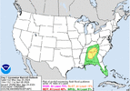
This is the day before landfall FYI
————————————————————
NWS Weather Prediction Center College Park MD
444 PM EDT Mon Sep 23 2024
Day 3
Valid 12Z Wed Sep 25 2024 - 12Z Thu Sep 26 2024
...THERE IS A SLIGHT RISK OF EXCESSIVE RAINFALL OVER PORTIONS OF
THE SOUTHEAST, TENNESSEE VALLEY, AND THE SOUTHERN APPALACHIANS...
20z Update:
The Slight risk over portions of AL, northern GA and southeast TN
looks in good shape. We very well could be looking at a PRE event
ahead of Helene as moisture associated with the tropical system
interacts with a front and upper jet. Overall the synoptic setup
looks quite favorable for excessive rainfall and global
deterministic model QPF is as high as 4-6" over portions of the
area. Given the convective nature of the QPF, it seems plausible
that rainfall totals could even exceed these values on a localized
basis. There is still some uncertainty on the exact location of
this higher rainfall axis. Todays model runs have shifted a bit
east, focusing more from eastern AL into northern GA and southeast
TN. The Slight risk remains a bit broad to account for this
uncertainty, but it does seem to cover the areas at greatest risk.
The ingredients in place and overall setup does suggest a MDT risk
could eventually be needed. However this depends on exactly how the
moisture streaming north ahead Helene ends up interacting with the
approaching trough/closed low and where exactly this interaction
happens. So while confidence in a flash flood risk is increasing,
think a higher end Slight risk is the best option for now.

JHS
Member
That is a huge change as it ends up northwest of Dothan AL at 84 hours.
And this is why getting all horned up over these mega model runs right now isn't the best idea.The NAM at 63 is much weaker and is northwest. 32MB weaker in fact.
I don't think anyone here is ignoring the ceiling of what this storm could be but there's an equally mediocre floor (or whatever words you want to use here). Many of these hurricane models are in the 970s low 980s roughly this time tomorrow. Might be best to wait and see what happens tonight bc right now the system doesn't look that great
- Status
- Not open for further replies.

