• Hello, please take a minute to check out our awesome content, contributed by the wonderful members of our community. We hope you'll add your own thoughts and opinions by making a free account!

Tropical MAJOR Hurricane Beryl 2024

AL02_GEFS.png


This next one is 96L, for comparison.

AL96_GEFS.png
 
According to the map at the bottom of page 11 it's through the worst of the shear and about to be out of it.
The cloud pattern seems to be better over the last 2 hours so it could be leveling off but pressure wa 953mb on the first pass this morning. We will soon know if it's steady state or weakening on subsequent center fixes
 
The cloud pattern seems to be better over the last 2 hours so it could be leveling off but pressure wa 953mb on the first pass this morning. We will soon know if it's steady state or weakening on subsequent center fixes
121200 1648N 07520W 7528 02088 9514 +219 +159 204017 028 041 001 00
7:12 CDT
 
06Z HWRF still bullseye on Jamaica at 942. We will see if it can drop that much in pressure since its currently at 951.

O6Z has moved further north of the Texas coastline moving toward Galveston at 957. Has room to lower pressure before landfall.

hwrf_mslp_uv850_02L_fh15-15.gifhwrf_mslp_uv850_02L_fh126-126 (1).gif
 
MHurricane Beryl Advisory Number 20
NWS National Hurricane Center Miami FL AL022024
1100 AM EDT Wed Jul 03 2024

...TROPICAL STORM CONDITIONS SPREADING ACROSS JAMAICA WITH
HURRICANE CONDITIONS EXPECTED DURING THE NEXT SEVERAL HOURS...
...EYE OF BERYL EXPECTED TO APPROACH THE CAYMAN ISLANDS TONIGHT
INTO THURSDAY...


SUMMARY OF 1100 AM EDT...1500 UTC...INFORMATION
-----------------------------------------------
LOCATION...17.1N 76.1W
ABOUT 75 MI...125 KM SE OF KINGSTON JAMAICA
ABOUT 365 MI...590 KM ESE OF GRAND CAYMAN
MAXIMUM SUSTAINED WINDS...145 MPH...230 KM/H
PRESENT MOVEMENT...WNW OR 285 DEGREES AT 18 MPH...30 KM/H
MINIMUM CENTRAL PRESSURE...954 MB...28.17 INCHES
At 1100 AM EDT (1500 UTC), the center of Hurricane Beryl was located
near latitude 17.1 North, longitude 76.1 West. Beryl is moving
toward the west-northwest near 18 mph (30 km/h), and this general
motion should continue through today, followed by a turn more toward
the west tonight or Thursday. On the forecast track, the center of
Beryl will pass near or over Jamaica during the next several hours.
After that, the center is expected to pass near or over the Cayman
Islands tonight or early Thursday and move over the Yucatan
Peninsula of Mexico Thursday night or early Friday.
 
Looking at the drop in the NE eyewall surface wonds were down to 77kts so it seems fight level winds aren't working down to the surface any longer

Hopefully that bodes well for Jamaica!

Hurricane Beryl Discussion Number 20
NWS National Hurricane Center Miami FL AL022024
1100 AM EDT Wed Jul 03 2024

Westerly shear is having an effect on Beryl this morning, as the eye
has all but disappeared in satellite imagery and the cloud pattern
has become ragged and elongated from southwest to northeast.
Reports from NOAA and Air Force Reserve Hurricane Hunter aircraft
indicate that the central pressure has risen to near 954 mb.
However, the Air Force plane measured flight-level winds of 139 kt
at 700 mb, while the NOAA plane measured 138-kt winds at 750 mb.
These winds support surface winds of 120-125 kt, and based on this
the initial intensity is held at 125 kt.

The initial motion is now 285/16. A strong mid-level ridge centered
over the southeastern US is expected to continue steering Beryl
generally west-northwestward at a decreasing speed for the next
couple of days or so. The motion should bring the center near or
just south of Jamaica during the next 6-12 h and south of the Cayman
Islands tonight. After that, the system should reach the Yucatan
Peninsula of Mexico in 36-48 h and emerge over the southwestern Gulf
of Mexico by 60 h. Once over the Gulf, there remains a sizable
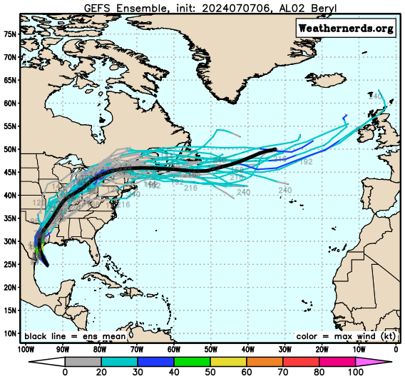
amount of spread in the track guidance, with the GFS and HWRF
showing a more northerly motion toward the Texas coast while the
ECMWF and UKMET show a more westerly motion toward the coast of
Mexico. This part of the track forecast lies near the consensus
models in the middle of the guidance envelope, and overall there are
no significant changes to the forecast from the previous advisory.

While there is some disagreement in how much shear Beryl will
encounter before reaching Yucatan, the intensity guidance expects
enough shear that it agrees on steady weakening. The official
forecast follows this and is at the high end of the guidance
envelope. Beryl should weaken more while over Yucatan, then slowly
re-intensify over the Gulf of Mexico in a somewhat more favorable
environment. The intensity forecast again calls for the cyclone to
regain hurricane strength before it reaches the western Gulf coast,
followed by weakening after landfall.
FORECAST POSITIONS AND MAX WINDS

INIT 03/1500Z 17.1N 76.1W 125 KT 145 MPH
12H 04/0000Z 17.8N 78.7W 115 KT 130 MPH
24H 04/1200Z 18.5N 82.3W 100 KT 115 MPH
36H 05/0000Z 19.0N 85.5W 90 KT 105 MPH
48H 05/1200Z 19.7N 88.2W 75 KT 85 MPH...INLAND
60H 06/0000Z 20.5N 90.7W 50 KT 60 MPH...OVER WATER
72H 06/1200Z 21.5N 92.9W 55 KT 65 MPH
96H 07/1200Z 23.5N 96.0W 65 KT 75 MPH
120H 08/1200Z 25.5N 98.0W 55 KT 65 MPH...INLAND

$$
Forecaster Beven
 
Hurricane Beryl Intermediate Advisory Number 20A
NWS National Hurricane Center Miami FL AL022024
200 PM EDT Wed Jul 03 2024

...HURRICANE CONDITIONS ABOUT TO SPREAD INTO JAMAICA AS THE EYE OF
BERYL APPROACHES...
...EYE OF BERYL EXPECTED TO APPROACH THE CAYMAN ISLANDS TONIGHT
INTO THURSDAY...


SUMMARY OF 200 PM EDT...1800 UTC...INFORMATION
----------------------------------------------
LOCATION...17.3N 76.9W
ABOUT 45 MI...70 KM S OF KINGSTON JAMAICA
ABOUT 320 MI...515 KM ESE OF GRAND CAYMAN
MAXIMUM SUSTAINED WINDS...140 MPH...225 KM/H
PRESENT MOVEMENT...WNW OR 285 DEGREES AT 18 MPH...30 KM/H
MINIMUM CENTRAL PRESSURE...959 MB...28.32 INCHES
 
Back
Top