Did you clear your cache Larry? Ens mean is almost -5 here...

Here’s 00z GEFS from NOAA, -4

And weatherbell 00z GEFS....


I was talking about this:

Did you clear your cache Larry? Ens mean is almost -5 here...
Here’s 00z GEFS from NOAA, -4
And weatherbell 00z GEFS....

What is weathermodels.com showing as far as surface temps are concerned at the same time?
In no way, shape, or form is this negative NAO within 1 sigma of normal as that image shows when both the high latitude blocking high over Greenland and corresponding trough south of Atlantic Canada have height anomalies >1-1.5 sigma. Coarse ensemble mean guidance will dampen extreme blocking regimes like this that's why both the Euro and GFS op are off the charts negative

It's fun to watch all the planetary waves in the Western Hemisphere and North Pacific retrograde as this high latitude block initially over Scandinavia goes to Greenland and eventually northern Canada. The trough over the west coast and ridging in the NE Pacific retrograde in the longer term and every cyclone over the North Atlantic occludes west of its predecessor, eventually we are gonna get a big cyclone near the eastern seaboard. This means the PNA will eventually go to neutral of even positive as the entire height field retrogrades west in response to this block
View attachment 4077
https://m.imgur.com/a/bn3lAWhat is weathermodels.com showing as far as surface temps are concerned at the same time?


Thanks!It doesn't have a 5 day mean on that site. Temps don't flip until day 12+ but then get colder as the run extends. View attachment 4079
View attachment 4078

This is CPC MRF model which not sure what that contains or is based on.
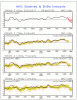
That is the GEFS mean based NAO 14 day forecast, which is the one we follow the most closely and jibes with the daily NAO index that we all follow. Since 1950, the most negative single day NAO has only been down to -3.254 (10/21/2002). There have been only 5 days since 1950 with the NAO below -3:
-3.254 10/21/2002
-3.095 7/14/1962
-3.048 10/20/2002
-3.022 10/22/2002
-3.004 7/13/1962
I'm not at all saying there's not a good possibility of a very strong -NAO coming up. I think there is. But let's be realistic. A very strong -NAO is somewhere in the -2 to low -3 range. The posted GFS charts' prediction of several days of -4 to -5 is what I'm not at all buying, especially when taking into account what I posted, which is what we always follow, the daily NCEP GEFS based forecast out 14 days. No single member even gets below -2 on any one day. So, do you really think we're going to have several days of sub -4 NAO?
So, here is my prediction: there will be a strong -NAO event that may or may not lead to a cold SE. (I'm leaning toward a cold period in early March but that's not what I'm currently debating.) But the daily index that has been followed for many years on wx boards will not get anywhere near as negative as -4 to -5. I predict it won't get below -2.5. I'll follow this closely and follow up with the verification after the NAO peaks. This is what has always been used and what I'll use for verification:
ftp://ftp.cpc.ncep.noaa.gov/cwlinks/norm.daily.nao.index.b500101.current.ascii
Does anyone want to bet on the NAO peaking more negative than -3.5, which would be a record breaker? If so, please reply to this and let me know. Don't be afraid. Better yet, if anyone wants to bet it will be -4 to -5, please indicate that here. I say strong -NAO but not below -2.5.

Sounds good.
If weatherbell or weathermodels use a different method to calculate it doesn’t matter. Like you stated a strong -NAO on CPC site is -2 or -3 or lower seems reasonable. It’s all pointing to a strong -NAO.
The weatherbell -4 isn’t the same as your -4, it’s probably closer to your -2. Again, it all depends on methodology in generating the anomalies and there seems to me multi day means and “smoothing” to the method you choose to follow, which makes it not as anomalous. The fact that -3 is that anomalous in the method you follow shows that. Either way, we’re talking about the same thing here.
A deeply negative NAO is coming, no matter what you use

The smoothing plus using a base period with more frequent +NAO regimes after the late 1970s (& is honestly more relevant to our bgd climate state) is somewhat to blame although the shorter base period wxbell and NOAA ESRL uses implies larger standard deviations which makes it more difficult to attain larger standardized anomaliesThe weatherbell -4 isn’t the same as your -4, it’s probably closer to your -2. Again, it all depends on methodology in generating the anomalies and there seems to me multi day means and “smoothing” to the method you choose to follow, which makes it not as anomalous. The fact that -3 is that anomalous in the method you follow shows that. Either way, we’re talking about the same thing here.
A deeply negative NAO is coming, no matter what you use
Sent from my iPhone using Tapatalk


GOOOO Larry!Happy hour doesn't disappoint.
Doesn’t dissapoint if you live in NYC or BOS!Happy hour doesn't disappoint.

I’ll take that bet! And roll with this guy....That is the GEFS mean based NAO 14 day forecast, which is the one we follow the most closely and jibes with the daily NAO index that we all follow. Since 1950, the most negative single day NAO has only been down to -3.254 (10/21/2002). There have been only 5 days since 1950 with the NAO below -3:
-3.254 10/21/2002
-3.095 7/14/1962
-3.048 10/20/2002
-3.022 10/22/2002
-3.004 7/13/1962
I'm not at all saying there's not a good possibility of a very strong -NAO coming up. I think there is. But let's be realistic. A very strong -NAO is somewhere in the -2 to low -3 range. The posted GFS charts' prediction of several days of -4 to -5 is what I'm not at all buying, especially when taking into account what I posted, which is what we always follow, the daily NCEP GEFS based forecast out 14 days. No single member even gets below -2 on any one day. So, do you really think we're going to have several days of sub -4 NAO?
So, here is my prediction: there will be a strong -NAO event that may or may not lead to a cold SE. (I'm leaning toward a cold period in early March but that's not what I'm currently debating.) But the daily index that has been followed for many years on wx boards will not get anywhere near as negative as -4 to -5. I predict it won't get below -2.5. I'll follow this closely and follow up with the verification after the NAO peaks. This is what has always been used and what I'll use for verification:
ftp://ftp.cpc.ncep.noaa.gov/cwlinks/norm.daily.nao.index.b500101.current.ascii
Does anyone want to bet on the NAO peaking more negative than -3.5, which would be a record breaker? If so, please reply to this and let me know. Don't be afraid. Better yet, if anyone wants to bet it will be -4 to -5, please indicate that here. I say strong -NAO but not below -2.5.
Red Sox vs YankeesDoesn’t dissapoint if you live in NYC or BOS!

I think if we get some blocking and we actually get out of phase 8 there might be a 2 week period or so of March where we can throw a Hail Mary.

Exactly. There is always a chance this pattern flop and everyone who rode the 1962 analog will be scratching their heads. Very important to look at everything, even if it looks boring or hot.HM always keeping it real

Per 12Z GFS, the SE finally gets a day that isn't warmer than normal on 3/1 (NC) or 3/2 (most others)! Celebration time!

Just for future reference & since I don't feel like repeating myself
Sounds like we aren't spending time in phases 8-2, which likely means less favorability for cold air.


What was that? a recurving typhoon? smhLol legit
Sent from my SM-G955U using Tapatalk
Exactly. There is always a chance this pattern flop and everyone who rode the 1962 analog will be scratching their heads. Very important to look at everything, even if it looks boring or hot.

We never thought MJO was going to spend 30 days in phase 7. Just cause models show it blasting through 8,1,2 into 3, doesn’t mean it will!We are spending time in those phases as we speak and I'm saying the -NAO will help push the MJO right along into phase 2-3. The OLR, upper level circulation anomalies, and lower-level zonal winds are clearly in the Eastern Pacific-Western Hemisphere (phase 8) right now. The plethora of southwestern Pacific TCs, rossby wave breaking in the East Pacific and sudden stratospheric warming have held the MJO back in phase 7 and projected onto U200 EOFs.
View attachment 4090
The upward branch of the MJO's upper level circulation is centered over South America & Africa (Phase 8-1)
View attachment 4091