Webberweather53
Meteorologist
NWS Little Rock does a fantastic job w/ these historical case studies, I commend them for being able to produce snow accumulation maps before 1895.


So the GFS doesn't like snow for NC, but does for TN, AL, and GA, the CMC has all, and the Euro I close for GA and AL in portions, but too warm in guessing except the mountains, but likes NC.The Euro joins the Canadian in showing snow over NC in the medium range.
View attachment 4522
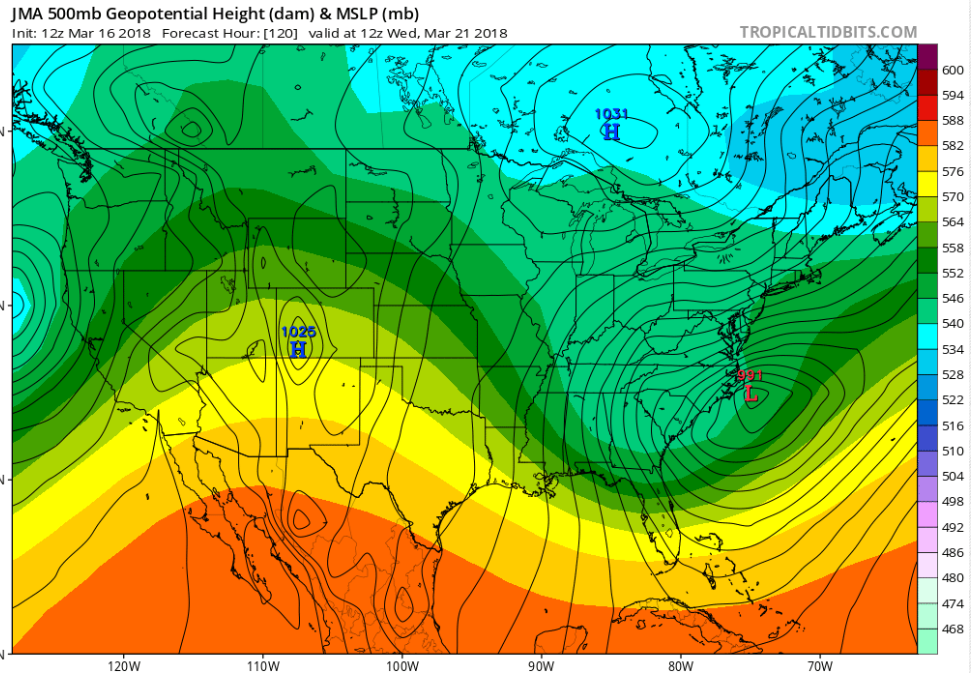
Oh boy!Grit posted the jma on amx:
I bet that precip map is awesome.Grit posted the jma on amx:

Go to the site and do the math on the previous map. I'm sure you'll like it's results.I bet that precip map is awesome.
Sent from my Z983 using Tapatalk
")
Did it look good for usGo to the site and do the math on the previous map. I'm sure you'll like it's results.
I'd guess the same as the GFS and CMC based off of the accumulated precip map. I wouldn't put much stock into it because it's so low of a resolution though.Did it look good for us

Sucks for Brent
Sucks for Brent
I can't believe it's 86 in Dallas today. That's nuts for mid March. It's a whopping 50 degrees colder in Omaha.Eh we'll see my forecast isnt too bad after this weekend talk of more fronts is a win this time of year
GFS has shown snow for NC at the same time in some runs just like the Euro and Canadian. Next Wednesday and Thursday definitely look interesting.So the GFS doesn't like snow for NC, but does for TN, AL, and GA, the CMC has all, and the Euro I close for GA and AL in portions, but too warm in guessing except the mountains, but likes NC.
http://w2.weather.gov/climate/xmacis.php?wfo=fwdI can't believe it's 86 in Dallas today. That's nuts for mid March. It's a whopping 50 degrees colder in Omaha.
I can't believe it's 86 in Dallas today. That's nuts for mid March. It's a whopping 50 degrees colder in Omaha.
I bet that precip map is awesome.
Sent from my Z983 using Tapatalk


Here is Nashville's write up on the St. Patrick's Day Storm. Think it may be Nashville's #1 or 2 of all time.NWS Little Rock does a fantastic job w/ these historical case studies, I commend them for being able to produce snow accumulation maps before 1895.
View attachment 4520
Annnndddd the happy hour GFS joins the party, backing up the 12z Euro and CMC.
View attachment 4526

So, what's the latest on the winter storm threat next week? Any good runs overnight?


