How much do you have down there? I think you all got the shaft with the February storm last year, so good to see you all outperform this time!It’s gonna snow longer than I can stay up
-
Hello, please take a minute to check out our awesome content, contributed by the wonderful members of our community. We hope you'll add your own thoughts and opinions by making a free account!
You are using an out of date browser. It may not display this or other websites correctly.
You should upgrade or use an alternative browser.
You should upgrade or use an alternative browser.
Wintry Machine Learning Mauler 1/30-2/1
- Thread starter SD
- Start date
We've been dealing with 2/3+ of the roads in the county remaining very icy from last weekend's event. Now with 6"+ everywhere, you can't see the ice patches anymore underneath the snow. It's going to be ugly here going into next week. I don't see much relief from the temperatures in the coming days. The sun will do its magic where it shines; but the shaded sections of roads will remain covered for a week plus.Seems probable. I've heard plows up and down SC9 tonight at times but no chance they get to the side roads. We should get pretty good evaporation tomorrow but those shaded areas are going to be a brick of ice Tuesday morning. That's if we even warm up enough to get real melting on Monday.
There's no way areas around New Bern and down towards Beaufort didn't get into blizzard criteria today. That entire area is over a foot with another 2-4 coming tonight. With winds increasing it's probably still possible.
We've been dealing with 2/3+ of the roads in the county remaining very icy from last weekend's event. Now with 6"+ everywhere, you can't see the ice patches anymore underneath the snow. It's going to be ugly here going into next week. I don't see much relief from the temperatures in the coming days. The sun will do its magic where it shines; but the shaded sections of roads will remain covered for a week plus.
What I really want to see is how cold we get tomorrow night. IMO somebody in eastern NC is making a run at zero. The pocosins especially with over a foot of snow on the ground.
I wonder if we will ever know why there was no blizzard warning issued, especially at the outer banks. It seems bizarre.There's no way areas around New Bern and down towards Beaufort didn't get into blizzard criteria today. That entire area is over a foot with another 2-4 coming tonight. With winds increasing it's probably still possible.
Attn @Shaggy @Avalanche from ILM:
Area Forecast Discussion
National Weather Service Wilmington NC
1256 AM EST Sun Feb 1 2026
.WHAT HAS CHANGED...
Banding along coastal southeast NC and extreme northeastern SC
will result in additional snow accumulations up to 6 inches.
Lighter accumulations are possible elsewhere. Dangerously cold
temperatures will continue through Monday morning. Another cold
weather advisory may be needed Monday night into Tuesday
morning.
....
Latest radar trends indicate that heavy snowfall is occurring
for most of southeastern NC and extreme northeastern SC. HREF
and deterministic hi-res guidance suggests that additional
snowfall could accumulate up to 6 additional inches. Satellite
corroborates these incredible snowfall rates with cloud tops
similar to a mini convective pulse. Locally higher amounts are
certainly possible where some of these intense bands reside.
I wonder if we will ever know why there was no blizzard warning issued, especially at the outer banks. It seems bizarre.
Outer Banks have had a hard time getting frozen precip today. Craven, Carteret, and Hyde counties seem to be the epicenter.
https://www.weather.gov/source/crh/snowmap.html
Impressive totals (and still rolling in). Looks like there are 3 distinct areas that took this storm on the chin

Impressive totals (and still rolling in). Looks like there are 3 distinct areas that took this storm on the chin
- The foothills in northeast TN and into the TN/NC mountains
- the I-85 corridor from CLT up towards Greensboro,
- the coastal plain.
Sctvman
Member
Crazy to see this in the temperatures we have had (low 20s and upper teens). Anything more would have caused major issues.
CNCsnwfan1210
Member
1:48 am: heavy snow still falling here in SW Wilson county with 6 inches of snow accumulation and drifts over 1 foot, a lot of blowing snow.
Sent from my iPhone using Tapatalk
Sent from my iPhone using Tapatalk
It depends on where one resides in Columbia. I'd guess around 5" or so in my neck of the woods.How’d Columbia do?
Man it’s still rocking down in Onslow, Jones, Craven and Carteret, wouldn’t be surprised to see a few places make a run at 20” somewhere down there. Calling it for the night, we are loosing saturation, flake size decreasing, final measurement will have to wait till first light. One for the books here, it’s the kind we always talk about and know can happen, the return interval is just not as often as many of us would like.
Shaggy
Member
Wind soeeds here aren't at that threshold . Certainly snowing at a very good clip. Need this band to slide back to the north a touch to put us under that maximum dbzWe are under that Deform band ATM, Coming off the Coast,, here in Pender/Hanover/Brunswick counties.. BLIZZARD conditions?
Radar returns are finally backing off here on my side of the border. Still going gangbusters on the NC side. Best measurement I can get on the krispy kreme box is 7". May add another inch or so.
Last edited:
Deformation band setting up? It's almost White-out conditions here on the Beach..
It's been there since midnight or so just not as well defined. It's starting to sag south following the meso low so I'm probably not done yet.
Btownheel
Member
Deformation band setting up? It's almost White-out conditions here on the Beach..
Bet Bald Head is a wild ride tonight.
Took a Jeb….errr….drive just now (family fast asleep). Plows out doing work but that’s the worst I’ve ever seen 85/40 in NC due to the temps. Absolutely covered and several
Inches deep. Did 5 miles between Elon and Graham and saw 1 other vehicle in either direction. No one out anywhere. Peaceful to the point of eerie.
Sent from my iPhone using Tapatalk
JimBobs
Member
It's finally over here. 1 mile southeast of SouthPark Mall in CLT. 9 accumulated inches of snow measured on 3 tables in my yard. The hours of flurries and small flakes at the end bumped me up from 8 inches to 9 inches.
.DISCUSSION...
KEY MESSAGE 1) Heavy snow will continue for part of the area
overnight. Hazardous travel and impacts to infrastructure will
continue for several days to come.
Latest radar trends indicate that heavy snowfall is occurring
for most of southeastern NC and extreme northeastern SC. HREF
and deterministic hi-res guidance suggests that additional
snowfall could accumulate up to 6 additional inches. Satellite
corroborates these incredible snowfall rates with cloud tops
similar to a mini convective pulse. Locally higher amounts are
certainly possible where some of these intense bands reside.
For the remainder of northeastern SC, the mesolow and upper very
max is gradually pushing offshore, just south of the Myrtle
Beach area. Places around Georgetown are finally starting to see
some flakes after being plagued by a dry slot for much of the
day. Accumulations will be lighter as precip rates remain light
in this region. Additional accumulations up to 3 inches will be
possible, primarily due to the atypical snow ratios. Some
locally higher amounts will be possible.
CNCsnwfan1210
Member
A little after 4 am 1mi W of Lucama NC in Wilson county, just have a few flurries falling but the accumulating snow has ended. Final total snow accumulation of 7 inches with 1 foot or so drifts noted around the periphery of houses and cars. Incredible storm for parts of the Carolinas to say the least. Glad to see that a lot of folks were able to see snow with this system whether it was a lot or a little. Near blizzard conditions still ongoing on the NC coast, incredible!
Sent from my iPhone using Tapatalk
Sent from my iPhone using Tapatalk
CNCsnwfan1210
Member
A little after 4 am 1mi W of Lucama NC in Wilson county, just have a few flurries falling but the accumulating snow has ended. Final total snow accumulation of 7 inches with 1 foot or so drifts noted around the periphery of houses and cars. Incredible storm for parts of the Carolinas to say the least. Glad to see that a lot of folks were able to see snow with this system whether it was a lot or a little. Near blizzard conditions still ongoing on the NC coast, incredible!
Sent from my iPhone using Tapatalk

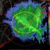
Current Newport/Morehead City radar
Sent from my iPhone using Tapatalk
Had to go to bed last night, but just woke up and wow! Maybe 6”. I’m not going out right now. I’ll post some pics in a few hours.
packfan98
Moderator
Good morning! Looks like it snowed here for 22-23 hours straight. I can’t accurately measure, but I’d estimate 13” or so. If you would have told me prior to this storm the it would end up being the biggest storm I’d ever had in my backyard, I wouldn’t have believed it.
znel52
Member
The powdery snow saved a lot of people from power outages. I noticed it was so dry it was having a difficult time sticking to trees and power lines. If this was heavy wet snow with that wind could have been major problems
Sent from my Pixel 8 Pro using Tapatalk
Sent from my Pixel 8 Pro using Tapatalk
packfan98
Moderator

1.5
Shaggy
Member
I'll never know how much we had. The drifting and blowing of snow is insane. Beside my house between the neighbors is a small yard. My side you can see grass my neighbors side has a 3 foot drift
I started a totals thread, it should helpful in consolidating obs since this thread is long. It would be cool for as many to post their totals there as possible
Observations - Mauler Totals Thread
Post your location, snow total, this split help with map making Chalybeate Springs, NC 1.5
southernwx.com
junbb1
Member
Morning moon set. View attachment IMG_8546.jpeg
Tokenfreak
Member
Ended up with only 2”. Far from the 4-8” various forecasters predicted for us. Big bust here unfortunately, but at least we got some I suppose.
CNCsnwfan1210
Member


Pic of 1 foot cornice snow drift, it was a pain to measure and obviously had to measure snow in open ground away from structures. It’s beautiful and super cold in Wilson county this morning.
Sent from my iPhone using Tapatalk
Downeastnc
Member
Wind howling this morning, its insane to see all the snow that is blowing around....
SnowDeac
Member
I had 2 flights canceled last night and already 2 replacement flights today. Total disaster. I’m currently booked on 3 different flights to get to Vegas for a big work event between this afternoon and tomorrow just trying to get there!Apparently the San Antonio Spurs couldn't fly out of CLT today after the Hornets spanked them this afternoon. 564 flights departing from CLT cancelled today, 512 flights arriving to CLT cancelled today. So far.
What happened last night? Best I can tell, we have an average of 16" on the ground but the wind is whipping, some spots are bare and some spots are close to 4ft.
And it's still snowing.
And it's still snowing.

LovingGulfLows
Member
- Joined
- Jan 5, 2017
- Messages
- 1,499
- Reaction score
- 4,100
Ugh, I should've taken the risk and went with a Raleigh bust in the snowfall contest thread. I did that in the last snowfall contest where I believe I predicted Memphis to bust and they ended up performing at or above their expected totals which totally screwed me.
Anyways, huge congratulations to everyone who got accumulating snow yesterday especially the areas that scored bigly! Very cool to see some of the areas that have been historically screwed over in recent years finally get a big one. I just hope that karma works one day in my favor and I see a big one eventually.