CltNative90
Member
I think that’s the case for a single day but the total in 2014 over 3 days was over 8 inches. Still pretty crazy.Brad just upped totals to 6-8. Clt last 5” snow was 2004 just insane
I think that’s the case for a single day but the total in 2014 over 3 days was over 8 inches. Still pretty crazy.Brad just upped totals to 6-8. Clt last 5” snow was 2004 just insane


RDU got 6”. Durham got 8”+. GSO has 14”.Didnt RDU get over 8” in December 2018?


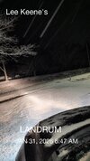
I thought this thing started at 3am?


We're about to be deathbanded
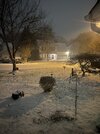
It’s already starting to look tasty. Imagine Fort Mill/Rock Hill are getting it pretty good right now.

It did. First flurries at 3:15am here.I thought this thing started at 3am?
Located in Baxter (Fort Mill) We are still light snow,that deathband is just south of me in Rock Hill, SC.
It’s already starting to look tasty. Imagine Fort Mill/Rock Hill are getting it pretty good right now.

I’ve been so stuck on fancy snow maps for the last 7 days i don’t even know what’s going on. I was promised 6” by sunrise..?I thought this thing started at 3am

I wish ffc would switch radar modes. GSP and CAE have it on 34 which picks up this fine snow much better than mode 35 which ffc has their and macon's radar on.Radar was looking healthy for a minute then went poof over n ga..slacked off. Got a dusting so far. Not sure what nws saw to up us to 3-6 inches but hopefully the radar fills more to the nw.
Explains why the NWS is upping totals. Looks to be going more negatively tilted vs some of the models. Also explains why it’s taking a bit long to get the precip to blossomH5 coming in and will begin to get more neutrally tilted and add more PVA aloft to the situation, everything should blossom more in the next few hours here
View attachment 192323

Correct. But I do think I'm cooked for 8 inch totals. The models seemed to overestimate the leading edge. Its been snowing for 4 1/2 hrs now and only amounted to a dusting. Seems the models had northern Spartanburg county between 2-3 by 7am. Unless I'm mistaken. If we only have 9-10 hrs left we have to maintain almost 1 inch per hour rates to get 8 inches. Not happening imo. Still think areas southeast of me do wellH5 coming in and will begin to get more neutrally tilted and add more PVA aloft to the situation, everything should blossom more in the next few hours here
View attachment 192323
Latest rap obliterates clt down to caeOut of CAE
The HREF LPMM and PMM indicates some isolated spots
potentially up to 12 inches in this heavier band across the
northern Midlands counties, nearer the NC border.
6z HRRR valid right now:Correct. But I do think I'm cooked for 8 inch totals. The models seemed to overestimate the leading edge. Its been snowing for 4 1/2 hrs now and only amounted to a dusting. Seems the models had northern Spartanburg county between 2-3 by 7am. Unless I'm mistaken. If we only have 9-10 hrs left we have to maintain almost 1 inch per hour rates to get 8 inches. Not happening imo. Still think areas southeast of me do well

What’s even better is those greens are going to start to pivot and move north to south. Greenville to CLT are in prime position to get smoked from these bands west to east and then north to south.
It’s already starting to look tasty. Imagine Fort Mill/Rock Hill are getting it pretty good right now.