Pretty big shift on the 18z UKMET. It only goes out to hr 66, but you can see things starting to set up at the end of it (it was a whiff at 12z).

This is a good indicator where they expect the ULL to travel, it is shown on this map pretty well
Mentioned this the other day. Happens almost every time. Still a good run, though.
CIPS Analogs (GFS-based) continue to suggest this storm's
potential ceiling could be exceptional, particularly in the
Carolinas. CIPS is keying in on several past major winter storms
that featured similar 300mb & 500mb evolutions to what the GFS is
showing, just 100-200 miles farther south and east from where those
events unfolded. While the CIPS analogs are analyzing the GFS, the
differences in the GFS versus the ECMWF are not all that different
when it comes to the meteorology involved: powerful closed upper
low, healthy upper-level divergence over a strengthening coastal
front, and tapping into Atlantic moisture revolving around the
closed 700mb low. In summary-- ensembles are beginning to identify
the floor of this winter storm (disruptive winter storm in the
southern Mid-Atlantic) but based on some of the analogs, there is a
potentially more significant-ceiling that could be achieved in the
Carolinas should guidance consolidate on a slower and more intense
winter storm. Given it is 72 hours out, there remains some caution
when it comes to expected snowfall totals.
Look at that minimum showing up more vividly in the foothills. I doubt the Foothills will even go under a winter storm watch we might have advisory level for 1 to 3 inches that’s gonna be my guess, but hey take whatever I can get.GEFS solid...kind of winshield wiping the past few runs.
View attachment 190823View attachment 190824

Look at that minimum showing up more vividly in the foothills. I doubt the Foothills will even go under a winter storm watch we might have advisory level for 1 to 3 inches that’s gonna be my guess, but hey ake whatever I can get.

12z WeatherNext probabilistic products
View attachment 190770View attachment 190771View attachment 190772
Complicated process but to put it short, it's basically where you get enhanced FGEN of the mountains and you try to form a low outside. I'll make a more detailed explanation later if you want itCan you explain this effect?
Come on now, you know this is the map you really wanted to post.New NWS graphics are out. Here’s the expected snowfall through 7pm Saturday.
View attachment 190827
")

It’s so funny seeing these maps knowing Roanoke-Blacksburg will not get anything more than 4 inches. Honestly completely useless to use and yes I’m serious.Newest National Blend of Models. Can I cash out now???
View attachment 190828
If we achieve that, we’re well on our way to two feet
North and more. Thanks for hosting those, Jon boy.ULL dynamics are quite difficult to forecast. The precip is going to be there with this setup.
Reading Gary Gray's old model summaries leading up to the '96 blizzard, models doubled their QPF predictions in the last 24-48 hrs. Things are going to swing, especially further east.

I think it is too I thought it was 2018 but I went to look in the NCSU database for winter storms and it wasn'tI want to say that happened with the Christmas / Boxing Day Storm of 2010, but I'm not 100% sure.
Just need to keep the dropping wave from going weaker and flatter, and yeah, lot of potential hereI see no reason to change my opinion in that this storm has the best chance of any we may have ever seen to overachieve.
Quote function works quite fine.This storm has the greatest potential to *UNDERPERFORM* expectations that we've ever seen. All week everyone's been hugging whatever map shows them getting a foot.
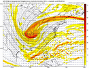
Very interesting. Can you tell us what we should be rooting for with our shortwave dropping down? I understand the general idea of digging sw and negative tilt. I’ve see some of the energy depicted pretty sharp and other times it’s more round like a bowling ball. What do we need?On the topic of the surface low pressure moving across Florida and into the Bahamas (upper middle image). It looks like to me that those lows are in response to the weakish southern stream waves (upper left image) - the first wave runs across the Deep South and there is a 2nd one moving west to east across the gulf. You can even see a comma head (lower left image) on the surface low coming out of the Bahamas. Then later, as our main upper wave drops in, surface low pressure forms close to the Carolina coast and strengthens as it moves NE. I think that's a realistic look. If we were going to bomb out a lone surface low off the SE coast, we probably would have needed to have a lone southern stream wave that was timed properly and tilted properly for intense phasing, slowing down of the trough, and tilting it negative.
View attachment 190822
Posting a map doesn't mean that is said poster's forecast. It's all part of the analysis / interest in the stormThis storm has the greatest potential to *UNDERPERFORM* expectations that we've ever seen. All week everyone's been hugging whatever map shows them getting a foot.
Really solid. Especially considering there’s hours of snow still to comeNew NWS graphics are out. Here’s the expected snowfall through 7pm Saturday.
View attachment 190827
I thought that's what the National Weather Service. Goes with. National blend of models? But their totals don't match up with that model. Just curious?Newest National Blend of Models. Can I cash out now???
View attachment 190828
Which of the many models that show me getting a foot or more should I hug the most? Euro, GFS, Canadian or NAM?This storm has the greatest potential to *UNDERPERFORM* expectations that we've ever seen. All week everyone's been hugging whatever map shows them getting a foot.
For sure and things can go wrong of course but if we can pull off 50% of what we’ve been seeing, this is the biggest storm since 2018 and maybe for a long time before that.Just need to keep the dropping wave from going weaker and flatter, and yeah, lot of potential here


It's probably gonna be higher than that because I don't think most models don't have the snow ending at 7pm Saturday Night
I'll never forget, Widre kept going on and on about the storm having this problem and that problem, and it ended up dropping the max amount (12 inches) on top of his house, lolFor sure and things can go wrong of course but if we can pull off 50% of what we’ve been seeing, this is the biggest storm since 2018 and maybe for a long time before that.

So RDU is in the 8-12” contour, but their point forecast is 5-6”? Is this another NBM vs. human forecast thing?New NWS graphics are out. Here’s the expected snowfall through 7pm Saturday.
View attachment 190827
I wish I hadn't peeked at the 21z RAP. Buzzkill. Man I sure hope this isn't a sign of major shifts with the 0z suite.
View attachment 190826
No, that graphic only goes through Saturday night at 7pm. The storm is not over.So RDU is in the 8-12” contour, but their point forecast is 5-6”? Is this another NBM vs. human forecast thing?