wow
Member
Convergence.. weaker GFS, stronger Euro .. I see a way my friends.

It depends on the model... GFS heeled back some.. Euro, UKMET, AIFS kicked up someHas the west trend stopped?
we're not even in range of the 3km nam. we have trends to endure that we haven't even fathomed yet. lock in!Has the west trend stopped?
I remember that as well...couldn't have happen to a worser guy...lolI'll never forget, Widre kept going on and on about the storm having this problem and that problem, and it ended up dropping the max amount (12 inches) on top of his house, lol
View attachment 190834
nah, I don't think so...this is ULL anything came happen...just sit tight!Running out of time for us to the west around Atl. Looks like we only have two models on our side.
Yep and we'll see it dance around until zero hour.The euro really didn’t look that much different at H5. That just looks like a deform band that starts showing up the closer we get to the event
The euro really didn’t look that much different at H5. That just looks like a deform band that starts showing up the closer we get to the event
This is maybe the best NC/SC HoF clown map I have ever seen
View attachment 190858
Final
Holy crap, keep that in mind that's 10:1, too. Moyock is probably approaching two feet with ratios, and that's probably over a foot for Raleigh. I was not expecting that. Basically 5"+ for most almost every county in NC.
Pinks moving west !18z Euro Trend
View attachment 190852
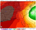
euro is several degrees colder at the surface too in north ga. widespread teens all afternoon west of athens. fascinating to see the models reflect that surface trough with temps about 5 degrees warmer than to the west and east.wow that's a big increase here in northeast ga. First time pink has been introduced into the state. I've been holding out hope we could get a fair bit more than consensus just based on the dynamics and track of the mid level lows...and the euro says..yep. Hope it's a trend.

Didn't your area score big on the March 1980 event? Like close to 30 inches?Moyock getting their annual foot of snow is nothing abnormal. We had a foot just over a year ago. We are the new snow capital of the Southeast.
What's amazing is looking back at the 18Z Euro from yesterday, there was a similar area/swath of snow, but the axis of 6-12+ inch totals was all the way in central to eastern SC/NC, and is now is 100-150 miles west right up underneath the ULL deformation zone. Taken at face value, there is a remote possibility of exceeding a half-foot of snow all the way into far northeastern GA, and I look foreword to the upcoming trends of this axis of heavy snow as we go into tomorrow. I just hope we don't loose this ground we gained.wow that's a big increase here in northeast ga. First time pink has been introduced into the state. I've been holding out hope we could get a fair bit more than consensus just based on the dynamics and track of the mid level lows...and the euro says..yep. Hope it's a trend.
Didn't your area score big on the March 1980 event? Like close to 30 inches?
 This is why I think you’re starting to see that big dog totals creeping more and more into the upstate. The stronger ULL helps too

Yep, Shelby down through Spartanburg and Laurens to near Greenwood. The exact area will of course change, but someone in the Carolina foothills and piedmont may very well get this much out of it. If this is anywhere close to being right all of us west of I-77 will be happy regardless of where that big band is.shelby winner

View attachment 190868
Huge increase on the EPS

Truly no clue what's up with this. Unsure why it keeps doing it. Perhaps it just stumbling upon better solution coincidentallyIt’s crazy the 6z/18z vs the 0z/12z. Looks like we should break our trend comparisons up. It’s screwy.
View attachment 190869