• Hello, please take a minute to check out our awesome content, contributed by the wonderful members of our community. We hope you'll add your own thoughts and opinions by making a free account!

Wintry Machine Learning Mauler 1/30-2/1

The AIFS (and ENS) has looked good of late with the geographical footprint of the precip (for NC/SC), but getting it to ramp back up with amounts was a bit of a watershed moment with the direction we appear to be going IMO (along with the other model improvement). Veddy Veddy nice. Would like to see the WNext just hold the location and increase on the amounts. Long way to go

In looking at the great Manitoba Maulers of the past, none of them have entered the U.S. east of North Dakota. Jan 2018 (entered in NDakota), Jan 2003 (E MT), Feb 1989 (ND), Feb 1984 (ND), Jan 1965 (ND)

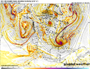
This is entering thru Minnesota. It's more like an Ontario Obliteration. Very steep drop into the SE. Very cold origin coming from the cold TPV. Very dynamic
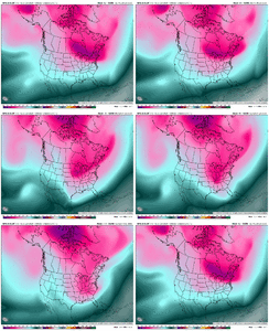
Jan 27 GFS AI 5T.gif
 
The AIFS (and ENS) has looked good of late with the geographical footprint of the precip (for NC/SC), but getting it to ramp back up with amounts was a bit of a watershed moment with the direction we appear to be going IMO (along with the other model improvement). Veddy Veddy nice. Would like to see the WNext just hold the location and increase on the amounts. Long way to go

In looking at the great Manitoba Maulers of the past, none of them have entered the U.S. east of North Dakota. Jan 2018 (entered in NDakota), Jan 2003 (E MT), Feb 1989 (ND), Feb 1984 (ND), Jan 1965 (ND)

This is entering thru Minnesota. It's more like an Ontario Obliteration. Very steep drop into the SE. Very cold origin coming from the cold TPV. Very dynamic

View attachment 190250
Very hard to believe it drops hard and fast enough to smoke us too, haha. But it seems like it’s happening, so i dunno
 
18z Euro has 1-2 inches in Atlanta with temperatures in the upper teens. So sick. @GaWx has that ever happened? View attachment 190244View attachment 190243
Not GaWx--but 2 events come to my mind.

-Jan 2018- I-85 corridor special- Solid 1-2" event that contained high ratios. I had temps around 18-20 for that entire event living in Decatur at the time.
-Jan 2014- 1-3ish event that snarled traffic because of the poor mesoscale analysis outside of anyone on a forum like this. Big ratios with the snow accumulating pretty efficiently with temps in the low 20s/upper teens.-Also in Decatur
 
I thought it doesn’t come out until 8? No?


Sent from my iPhone using Tapatalk
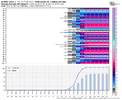
The raw data dropped at exactly 7:38pm ET, I downloaded a subsect of the ZARR and inspected a few of the members' raw data in my Zarr renderer and they look wild. Awaiting the full ensemble & pretty plots to generate (takes some time)
 
The raw data dropped at exactly 7:38pm ET, I downloaded a subsect of the ZARR and inspected a few of the members' raw data in my Zarr renderer and they look wild. Awaiting the full ensemble & pretty plots to generate (takes some time)

Wow that’s crazy! Thanks for what you do


Sent from my iPhone using Tapatalk
 
Sorry if this is banter but I found this to be quite neat
da2b312a2ec3c14e99ea93bd966634c5.jpg


Sent from my iPhone using Tapatalk
 

Best news of the day to see AIFS trend west so dramatically. Wow! And look how far west the Euro went, @Webberweather53 milestone in Tennessee. I leave work and do dishes and all of a sudden I’m staring down a legit snow.

The AIFS (and ENS) has looked good of late with the geographical footprint of the precip (for NC/SC), but getting it to ramp back up with amounts was a bit of a watershed moment with the direction we appear to be going IMO (along with the other model improvement). Veddy Veddy nice. Would like to see the WNext just hold the location and increase on the amounts. Long way to go

In looking at the great Manitoba Maulers of the past, none of them have entered the U.S. east of North Dakota. Jan 2018 (entered in NDakota), Jan 2003 (E MT), Feb 1989 (ND), Feb 1984 (ND), Jan 1965 (ND)

This is entering thru Minnesota. It's more like an Ontario Obliteration. Very steep drop into the SE. Very cold origin coming from the cold TPV. Very dynamic
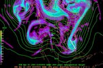
View attachment 190250

This is why I’ve been so skeptical of the threat, the general theme was so coastal scraper, out to sea, and last second. No way it could drop so east and still get south and west and below us. But so far it looks like it wants to.
 
A big key to this setup is slowing down the northern stream wave enough to let the southern stream disturbance get out in front of it when they phase. This causes your wave to tilt negatively much more quickly, amps your coastal low up, and throws more heavy snow back further to the north & west, etc.

If we can get the northern stream wave to slow enough and force our upper trough to go neutrally tilted before it crosses the apps, I think we’re looking at a real big dog event in NC. In a perfect world, I’d like to see us do that over central TN like the 12z GFS shows, but beggars can’t be choosers.

Guidance is generally trending in this direction w/ a slower northern stream wave and quicker tilt which I would like to see continue the next day or two
 
View attachment 190251
View attachment 190254

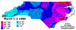
Top: March 1-2, 1980
Bottom: January 31, 2026

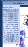
I saw some talk about the 1980 storm and... honestly... I can see it aside from a couple small differences.

By then, yes it's quite similar. But getting to that point they took different courses. March 80 started further west with a stronger southern wave and a GOM low forming... a more conventional setup I suppose.

1769562842783.png
 
The raw data dropped at exactly 7:38pm ET, I downloaded a subsect of the ZARR and inspected a few of the members' raw data in my Zarr renderer and they look wild. Awaiting the full ensemble & pretty plots to generate (takes some time)

Since *technically* this is the machine learning thread, is it okay for you to explain (and perhaps in private messages if it actually doesn't apply here) what a/the ZARR is?
 
Since *technically* this is the machine learning thread, is it okay for you to explain (and perhaps in private messages if it actually doesn't apply here) what a/the ZARR is?
This is banter… but chatGPT is actually really good to ask weather questions to.

(I asked the question in a chat thread where I uploaded a sounding from last weekend, hence the name of the chat)

One-sentence definition
A weather model Zarr is a cloud-optimized, chunked storage format that lets users access only the specific pieces of massive weather model datasets they need, without downloading entire files.
 
Back
Top