This shower near me has had lottttsss of rising scud, kinda cool
Man, you have been lucky these past two days. It did pour last night, but nothing here, yet.
This shower near me has had lottttsss of rising scud, kinda cool
Outflow. Snoozer here dropped us back from 88 to 85 with a little breezeHmm... appears to be some sort of outflow boundary south of Raleigh, moving west. Interesting feature if that's what it is? Might trigger some development?
Outflow. Snoozer here dropped us back from 88 to 85 with a little breeze
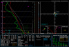
Most CAMs weaken those storms as they head north due to loss of heating and the development of MLCIN, and re-fire storms around CLT tomorrow as some energy aloft moves through, hrrr shows this, could see a isolated severe storm tomorrow as the warm mid levels will basically be gone..NEAR TERM /THROUGH TUESDAY/...
As of 800 PM EDT Monday: High cirrus has generally limited
convection this evening, but the most interesting feature of note is
a band of storms pivoting northward through NE GA and the Midlands
associated with a vort lobe connected to Cristobal. There should be
up to 1000 J/kg of lingering sbCAPE into the early overnight hours,
and there`s little reason to think that the band won`t make it into
our area in some way shape or form. Pops have been updated to
account for this band. For this reason, showers and a possible storm
are expected to move through much of the area well into the
overnight hours, likely after midnight.
And just as soon as this is wrote that band falls apart.


 ️
️


78 degrees at 5 am, June 9, CHA.. pretty remarkable warm low.
If it was April it might be remarkable, but it's June !78 degrees at 5 am, June 9, CHA.. pretty remarkable warm low.

While it is well above average, I wouldn't call it remarkable.If it was April it might be remarkable, but it's June !
That's more snow than I've seen in a decade
78 degrees at 5 am, June 9, CHA.. pretty remarkable warm low.
Well lets see if we can kick off a storm or 2 today. Good recipe for outflows to spark new storms and the sea breeze to get something going
Yeah we kind of suck with focus/forcing right now and are really depending on any subtle features (outflows, sea breeze) and heating to get things going. We are in a little bit better position than yesterday with a bit more moisture and instability. Really looks like more of the same through late tomorrow, but by tomorrow night into Thursday we get the front into play. I have high hopes on coverage and totalsHere's to hoping. Yesterday was a complete dud!
Well lets see if we can kick off a storm or 2 today. Good recipe for outflows to spark new storms and the sea breeze to get something going
Man the air is as soupy as I have ever experienced in this part of the state. It's a shame we can't squeeze out more showers/storms in this air mass.
Man the air is as soupy as I have ever experienced in this part of the state. It's a shame we can't squeeze out more showers/storms in this air mass.
Well to the southwest though. Got a long way to go to get into the GSP and Charlotte areas.Man, the radar is exploring to the SW, come on storms. I would hate to see another dud of a day today.
.gif")
H/t to @Myfrotho704_ for seeing this earlier...
Starting to look like we're about to see a mini repeat of that cut off upper low in late May that dumped a lot of rain over the Carolinas.


They aren't making it to GSP this evening. They've lowered pops to only 30%.Well to the southwest though. Got a long way to go to get into the GSP and Charlotte areas.
.png")