I caught it, while moving family into new home lol and on way back road. By Whiteville it was a faded memory. We where so wet from sweat ,it didnt matter.I'll gladly take a 1/4 inch and be happy but oh man did I just barely miss out on the Seabreeze stuff today
-
Hello, please take a minute to check out our awesome content, contributed by the wonderful members of our community. We hope you'll add your own thoughts and opinions by making a free account!
You are using an out of date browser. It may not display this or other websites correctly.
You should upgrade or use an alternative browser.
You should upgrade or use an alternative browser.
Pattern June 2024
- Thread starter SD
- Start date
JHS
Member
Pouring right now.
Our drought monitor map is gonna look a lot more colorful very soon:

Downeastnc
Member
Need the last half of the 12Z GFS to be right over 6" behind for the year and the corn crop will fail if we dont get it soon....
Good news bad news coming. Good news is higher pwats, greater low level moisture, dews in the 70-75 range, and the ridge center moving away will lead to at least some storms each day maybe starting as early as late Friday but more likely late Saturday. Bad news is with the ridge retrograding SW all of the high 850s are going to move right into the area so highs are more likely 95-100 with HIs well into the 100s.Need the last half of the 12Z GFS to be right over 6" behind for the year and the corn crop will fail if we dont get it soon....
I am really hopeful that as we get out towards the end of the month we avoid centering another ridge overhead like the 12z gfs and getting another front through like the cmc. If we split those 2 with a deep WNW flow aloft and a bermuda ridge we still stay hot but it's a much wetter heat wave
Last edited:
Downeastnc
Member
Good news bad news coming. Good news is higher pwats, greater low level moisture, dews in the 70-75 range, and the ridge center moving away will lead to at least some storms each day maybe starting as early as late Friday but more likely late Saturday. Bad news is with the ridge retrograding SW all of the high 850s are going to move right into the area so highs are more likely 95-100 with HIs well into the 100s.
I am really hopeful that as we get out towards the end of the month we avoid centering another ridge overhead like the 12z gfs and getting another front through like the cmc. If we split those 2 with a deep WNW flow aloft and a bermuda ridge we still stay hot but it's a much wetter heat wave
Yeah at least it's tolerable right now....this weekend we are trading that for a low chance at a hit or miss storm...at least I haven't had to mow the yard in almost 2 weeks now
BHS1975
Member
Yeah at least it's tolerable right now....this weekend we are trading that for a low chance at a hit or miss storm...at least I haven't had to mow the yard in almost 2 weeks now
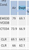
Yeah low 60s dew points ain't bad for this time of year.
Sent from my iPhone using Tapatalk
Yeah, it's comfortable in the evenings. Desert weather, hot days cool nights, 58 yesterday morning, 61 this morning with highs low 90s. Crops and grass taking a beating thoughYeah at least it's tolerable right now....this weekend we are trading that for a low chance at a hit or miss storm...at least I haven't had to mow the yard in almost 2 weeks now
Quite breezy conditions off the ocean making it pretty tolerable the last couple of days. This was helped today by highs staying in the 80s throughout the area along with mid 60s dews. Going to get a good walk in shortly in the breeziness.
Downeastnc
Member
Pretty bleak for the Carolinas...

59 again this morning. I know it's a trade-off because it is bone dry. But man, these mornings have felt amazing.
Wouldn't this be nice for the fourth of July. Lots of highs in the low/mid 80s board wide with these dew points:
6z GFS for mid-day July 4th

A run yesterday showed dew points in the 70s so this is just a dream right now.
6z GFS for mid-day July 4th
A run yesterday showed dew points in the 70s so this is just a dream right now.
Rdus records highs are in trouble Saturday and Sunday imo
With the dry ground, the temps will jump fast in the morning.Rdus records highs are in trouble Saturday and Sunday imo
Iceagewhereartthou
Member
The weather starting this Friday through the following 7-10 days looks miserable. And while I'm enjoying some drier weather for a change, this time of year dry brings hotter temps so I'll be pulling for more clouds at least. Anyway we slice it though, we're in that roughest time of year and there's no escape. DAYS START GETTING SHORTER AFTER TOMORROW!
GFS making a little noise for possible rain across GA/SC next week
Well the last what I would consider significant rain .5+ dropped out of the last 30 days today so my 30 day total is sitting at .38 now. It's actually impressive tbh
Shaggy
Member
Brunswick county water corporation has placed an irrigation restriction. Too much strain in the system as we all combat the crispness of the grass
Looks like Johnston went with voluntary restriction, I might be pounding the bermuda with water the best few days in case harnett doesBrunswick county water corporation has placed an irrigation restriction. Too much strain in the system as we all combat the crispness of the grass
Shaggy
Member
Yeah I don't know if brunswick has stages 1-3 but they jumped straight to stage 4.Looks like Johnston went with voluntary restriction, I might be pounding the bermuda with water the best few days in case harnett does

H2GO issues stage 4 water shortage alert, prohibiting all irrigation - WWAYTV3
Brunswick Regional Water & Sewer H2GO has issued a Stage 4 Water Shortage Alert.
 www.wwaytv3.com
accu35
Member

Brent
Member
Our sunrise gets a minute later tomorrow...
Starting the march to winter
Starting the march to winter
GFS still leaning into some, maybe not much, potential rain next week for GA/SC. Euro dries up anything that gets into mid/north GA. Canadian also suggesting a lot of isolated afternoon showers for our areas.

I wish Florida would send some of that deluge they received earlier this week our way. It does look like the chances for rain do increase next week. At least they aren't an absolute zero as they are now. Hopefully Monday will bring some relief for Central North Carolina and next week will provide more opportunities for rain.
The heat is on.

Just took a walk and its really pleasant outside. Current temp is 82/62 with a nice breeze. Funny how weather patterns work; Augusta Maine is currently 94/70. We'll pay for this in the next few days but enjoy it while we can.
We probably get a break with highs back in the 85-92 range the 2nd half of next week into that weekend but the heat is right back for the week of the 4th
We're almost there
Downeastnc
Member
We're almost there
I believe it when they say we are teetering on the edge of falling into a pretty serious drought....
We have hit 90 or higher for the last 9 days, and its well above 90 everyday in the forecast for the next 7 days, I am not sure what the record for straight 90 degree days are ( and I am sure the number is probably stupid high ) but its been awhile since we have had this kind of persistent heat....We have had .33 of rain the last 30 days....and the last time it rained was 14 days ago.
JHS
Member
We may have to go back to 1993 for a persistent run of heat like this is shaping up to be. 2007 was awful, but that came mostly in a 3 week stretch. 1986 was rough too and lasted nearly 2 months. This is looking like it might give those years a run for their money, and if we do get something like those, July will be awful. 2007 was not too bad until August when we had plenty of 100 degree days. Thankfully we are not nearly as dry as we were in 1986, when in the middle of July GSP had only had around 14.5 inches of rain for the year.I believe it when they say we are teetering on the edge of falling into a pretty serious drought....
We have hit 90 or higher for the last 9 days, and its well above 90 everyday in the forecast for the next 7 days, I am not sure what the record for straight 90 degree days are ( and I am sure the number is probably stupid high ) but its been awhile since we have had this kind of persistent heat....We have had .33 of rain the last 30 days....and the last time it rained was 14 days ago.
Still think we see the ridge get back well west in time and we run widespread AN rain anoms for a while after 7/4. Still a few good shots regionally before then
Shaggy
Member
ILM increasing my rain chances through the weekend. Feeling good about the chances as the onshore flow increasesStill think we see the ridge get back well west in time and we run widespread AN rain anoms for a while after 7/4. Still a few good shots regionally before then
Yeah your chances look better this weekend along the coast. Models paint a typical hit or miss scenario here with small amounts for those that do get a storm. This anomalous dry pattern has really parched the land. Again the mornings have been fabulous, with only 2 overnight lows of 70 so far on the 21st of June. With several upper 50s low 60s, but you only get that with a very dry airmass in place. I think we get on the cusp of serious drought issues before the pattern flips as Shane has been alluding too.ILM increasing my rain chances through the weekend. Feeling good about the chances as the onshore flow increases
Shaggy
Member
Yeah here the water levels are dropping in the ponds quick and we have been really flat on rainfall for the last 6 weeks or so. You guys inland are in much worse shape as we have had a day or 2 of sea breeze showers that gave me a quick. 25 inch.Yeah your chances look better this weekend along the coast. Models paint a typical hit or miss scenario here with small amounts for those that do get a storm. This anomalous dry pattern has really parched the land. Again the mornings have been fabulous, with only 2 overnight lows of 70 so far on the 21st of June. With several upper 50s low 60s, but you only get that with a very dry airmass in place. I think we get on the cusp of serious drought issues before the pattern flips as Shane has been alluding too.
With the heat coming things are gonna dry up quickly in your neck of the woods. We are already under an irrigation ban yall might be looking at one soon too.
I think we have at least 3 legitimate chances over the next 10 days. The first Sunday-tuesday is the most questionable with the potential for the prefrontal trough to skip us but mid to late week next week looks good right nowYeah your chances look better this weekend along the coast. Models paint a typical hit or miss scenario here with small amounts for those that do get a storm. This anomalous dry pattern has really parched the land. Again the mornings have been fabulous, with only 2 overnight lows of 70 so far on the 21st of June. With several upper 50s low 60s, but you only get that with a very dry airmass in place. I think we get on the cusp of serious drought issues before the pattern flips as Shane has been alluding too.
need some rain here, really really bad
golfer side of me says- wonder how all those bentgrass greens are going to hold up in the northeast
in the summer of 2011 basically every course in wilmington that used bentgrass had to switch to championship bermuda because it was so hot and dry and it left bare spots on every green
golfer side of me says- wonder how all those bentgrass greens are going to hold up in the northeast
in the summer of 2011 basically every course in wilmington that used bentgrass had to switch to championship bermuda because it was so hot and dry and it left bare spots on every green
Shaggy
Member
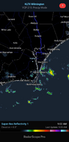
Once the wind veers SE this evening and the seabreeze rolls through that'll be the end of the low mixed daytime dews
Shaggy
Member
Already happened here and it's noticeable compared to the nice dry dp we have been having. Nice batch of showers developing offshore so I've got my fingers crossedOnce the wind veers SE this evening and the seabreeze rolls through that'll be the end of the low mixed daytime dews
EDIT temp and DP over the last 4 hours has really juiced up here.