Coming down in sheets
-
Hello, please take a minute to check out our awesome content, contributed by the wonderful members of our community. We hope you'll add your own thoughts and opinions by making a free account!
You are using an out of date browser. It may not display this or other websites correctly.
You should upgrade or use an alternative browser.
You should upgrade or use an alternative browser.
Pattern June 2022
- Thread starter SD
- Start date
CTG lightning. Big boomers. One just hit about 100 yards from me at the gas station. I forgot to wear my shittting pants today
You don’t have anymore! They all exploded during the snow blizzardcane you got last winterCTG lightning. Big boomers. One just hit about 100 yards from me at the gas station. I forgot to wear my shittting pants today
Does CJ have his sleeves rolled up???CTG lightning. Big boomers. One just hit about 100 yards from me at the gas station. I forgot to wear my shittting pants today
That late June sun angle can work wonders.
DFW made it to 94*F today, several degrees above forecast. However, the dewpoint were a decent bit higher (mid/uper 60s), so the heat index was at 96*F.
Furthermore, with a low of 73*F, the day will end exactly at average for the record book.
That said, this is the first time since 6/10 the high was less than 95*F.
.18. Pathetic.
I don’t think I even saw that much. I don’t understand why this line dried up so much when it made it down here, especially after the talk of possible heavy rain..18. Pathetic.
Turning sprinklers on…
Bannerdude
Member
A very welcome 0.41" today
Rockets my June total up to 1.23"
Rockets my June total up to 1.23"
D
Deleted member 609
Guest
More rain. So sick of all this rain
I'd say I'm back in the running. Thursday makes 2 weeks since my last measurable rain.That is correct. They will hold water really well when saturated, but I didn't think discussing that was useful as we have obviously exhausted the moisture available in the top 4-6 inches of soil based on the grasses...
On most years you could add @RainlessSnowless & Grumpy but he's got rain this month.
.6 today, I'm rolling now, 1.67 for the month
Brent
Member
Another stunning summer day here in the 80s with low humidity. Gonna miss this when it inevitably gets gross again. I saw so many people out this evening walking biking... Just soaking it up
We could really use some rain though... It's been weeks. The weekend looks to have some promise
We could really use some rain though... It's been weeks. The weekend looks to have some promise
Downeastnc
Member
00Z GFS was nice, expect 06Z to take it all away....

It would be nice. But I'll believe it when it actually happens. I hate to say it, but we need a tropical system (...weak). Something widespread and lasting. I ended up with .05" yesterday. That was horrible for the look of the storms as they were approaching the Triangle yesterday.00Z GFS was nice, expect 06Z to take it all away....
This seems more realistic00Z GFS was nice, expect 06Z to take it all away....

HugeSnowStick
Member
000000000.1 at my rain sheild area yesterday.
Dews in the 50s again. Awesome. Can't wait for 76/72 Christmas afternoon
LickWx
Member
I can only dream . Mmmmmmm! F the northeast winds .Dews in the 50s again. Awesome. Can't wait for 76/72 Christmas afternoon
smast16
Member
I got some stratiform rain on the trailing end of that line. Got a whopping 0.18" as well. I mean it's better than none, but less than 2 tenths aint fixing any problems..18. Pathetic.
Going to finish the month with 1.07". Lets hope this pattern change comes as advertised and not another mirage.
I'm hoping for mirage but this time we actually get hotI got some stratiform rain on the trailing end of that line. Got a whopping 0.18" as well. I mean it's better than none, but less than 2 tenths aint fixing any problems.
Going to finish the month with 1.07". Lets hope this pattern change comes as advertised and not another mirage.
smast16
Member
Run was amazing for a June morning. You really can't beat 61 and low dews.
smast16
Member
I was referring to Shaggy's rain porn, but I can see where that's heading.I'm hoping for mirage but this time we actually get hot

JHS
Member

U.S. supercomputers for weather and climate forecasts get major bump
Today, NOAA inaugurated the nation’s newest weather and climate supercomputers with an operational run of the National Blend of Models. The new supercomputers, first announced in February 2020 with a contract award to General Dynamics Information Technology (GDIT), provide a significant upgrade...
This may interest some of us.
BHS1975
Member
But can it run Crysis?U.S. supercomputers for weather and climate forecasts get major bump
Today, NOAA inaugurated the nation’s newest weather and climate supercomputers with an operational run of the National Blend of Models. The new supercomputers, first announced in February 2020 with a contract award to General Dynamics Information Technology (GDIT), provide a significant upgrade...www.noaa.gov
This may interest some of us.
With a bit more convective debris, only made it up to a cool 92*F at DFW today.
Shaggy
Member
Can't make this stuff up. How about this screw Jon @SD @Rain Cold
Attachments
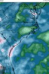
Slam dunk! I need CJ analysis on this! NW to SE movement! 
This was somewhere near me???
Had some good rain this morning.

Shane must be out playing in the mud puddles......
National Weather Service Raleigh NC
907 AM EDT Wed Jun 29 2022
NCC085-101-291415-
/O.CON.KRAH.FA.Y.0034.000000T0000Z-220629T1415Z/
/00000.N.ER.000000T0000Z.000000T0000Z.000000T0000Z.OO/
Harnett NC-Johnston NC-
907 AM EDT Wed Jun 29 2022
...FLOOD ADVISORY REMAINS IN EFFECT UNTIL 1015 AM EDT THIS MORNING...
* WHAT...Flooding caused by excessive rainfall continues.
* WHERE...A portion of central North Carolina, including the
following counties, Harnett and Johnston.
* WHEN...Until 1015 AM EDT.
* IMPACTS...Minor flooding in low-lying and poor drainage areas.
Ponding of water in urban or other areas is occurring or is
imminent.
* ADDITIONAL DETAILS...
- At 907 AM EDT, Doppler radar indicated heavy rain due to
thunderstorms. Minor flooding is ongoing or expected to begin
shortly in the advisory area. Up to 2 inches of rain have
fallen.
- Some locations that will experience flooding include...
Lillington, Dunn, Angier, Benson, Erwin, Coats, Four Oaks,
Buies Creek, Raven Rock State Park, Anderson Creek,
Timberlake, Seminole, Coats Crossroads and Pineview.
Flood Advisory
Flood AdvisoryNational Weather Service Raleigh NC
907 AM EDT Wed Jun 29 2022
NCC085-101-291415-
/O.CON.KRAH.FA.Y.0034.000000T0000Z-220629T1415Z/
/00000.N.ER.000000T0000Z.000000T0000Z.000000T0000Z.OO/
Harnett NC-Johnston NC-
907 AM EDT Wed Jun 29 2022
...FLOOD ADVISORY REMAINS IN EFFECT UNTIL 1015 AM EDT THIS MORNING...
* WHAT...Flooding caused by excessive rainfall continues.
* WHERE...A portion of central North Carolina, including the
following counties, Harnett and Johnston.
* WHEN...Until 1015 AM EDT.
* IMPACTS...Minor flooding in low-lying and poor drainage areas.
Ponding of water in urban or other areas is occurring or is
imminent.
* ADDITIONAL DETAILS...
- At 907 AM EDT, Doppler radar indicated heavy rain due to
thunderstorms. Minor flooding is ongoing or expected to begin
shortly in the advisory area. Up to 2 inches of rain have
fallen.
- Some locations that will experience flooding include...
Lillington, Dunn, Angier, Benson, Erwin, Coats, Four Oaks,
Buies Creek, Raven Rock State Park, Anderson Creek,
Timberlake, Seminole, Coats Crossroads and Pineview.
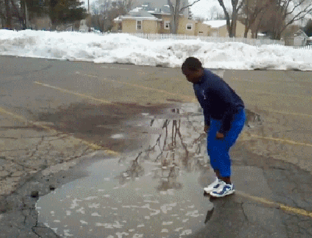
.19Shane must be out playing in the mud puddles......
Flood Advisory
Flood Advisory
National Weather Service Raleigh NC
907 AM EDT Wed Jun 29 2022
NCC085-101-291415-
/O.CON.KRAH.FA.Y.0034.000000T0000Z-220629T1415Z/
/00000.N.ER.000000T0000Z.000000T0000Z.000000T0000Z.OO/
Harnett NC-Johnston NC-
907 AM EDT Wed Jun 29 2022
...FLOOD ADVISORY REMAINS IN EFFECT UNTIL 1015 AM EDT THIS MORNING...
* WHAT...Flooding caused by excessive rainfall continues.
* WHERE...A portion of central North Carolina, including the
following counties, Harnett and Johnston.
* WHEN...Until 1015 AM EDT.
* IMPACTS...Minor flooding in low-lying and poor drainage areas.
Ponding of water in urban or other areas is occurring or is
imminent.
* ADDITIONAL DETAILS...
- At 907 AM EDT, Doppler radar indicated heavy rain due to
thunderstorms. Minor flooding is ongoing or expected to begin
shortly in the advisory area. Up to 2 inches of rain have
fallen.
- Some locations that will experience flooding include...
Lillington, Dunn, Angier, Benson, Erwin, Coats, Four Oaks,
Buies Creek, Raven Rock State Park, Anderson Creek,
Timberlake, Seminole, Coats Crossroads and Pineview.
BHS1975
Member
Dude WTF.
I guess a weekly total of .37 is enough for Flood products these days lol ?
Last edited:
Im 100% certain I'm cursed. I wish whoever cursed me would stop now it's not fun anymoreDude WTF.
I mean Lick has some weird vibes so I'd start with himIm 100% certain I'm cursed. I wish whoever cursed me would stop now it's not fun anymore
smast16
Member
Wait there's rain? It's sunny here. Rain from Monday is already used up and grass curled up again.
You willing to give up some feet pics to break the curse??Im 100% certain I'm cursed. I wish whoever cursed me would stop now it's not fun anymore
Picked up 1” here last night
This should end up being the 5th warmest June on record for Dallas, only behind 1953, 2011, 2010, 2008 and 1980.