Big rain north, south, east, west up, and down. Sink zone doing work.
-
Hello, please take a minute to check out our awesome content, contributed by the wonderful members of our community. We hope you'll add your own thoughts and opinions by making a free account!
You are using an out of date browser. It may not display this or other websites correctly.
You should upgrade or use an alternative browser.
You should upgrade or use an alternative browser.
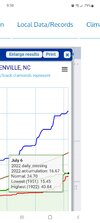
Pattern July '22
- Thread starter Detective WX
- Start date
?


JHS
Member
Got 1.35 here tonight.
DCK
Member
No rain gauge but my house was hammered in northern Spartanburg county. I joked to my wife that it looks like the rain will miss us again. Then it absolutely poured for over an hour. Thankful for the rain but maybe a little more moderate next time.
What a great HRRR run 0.00 through 48 hrs here and RAH was talking about flood watches ?
 (9).png")
BHS1975
Member
Looks like
You can take that to the bank.What a great HRRR run 0.00 through 48 hrs here and RAH was talking about flood watches ?
View attachment 119724
whatalife
Moderator
It doesn’t rain in June but in July it doesn’t stop. 
What is the deal with the busted forecasts lately for storms and rain here?What a great HRRR run 0.00 through 48 hrs here and RAH was talking about flood watches ?
View attachment 119724
Downeastnc
Member
NAM3k has this weird little cluster fire over NE NC that drops SW into the main line....destroys my county with 5-7" of rain in like 3 hrs....I mean I need rain but not that much....

Downeastnc
Member
Settle down NAM some 12-16" totals just south of MBY....this would put a dent in the drought though obviously we got NAMd, still figure some widespread 1-3" totals likely....

Last edited:
Bannerdude
Member
0.01"
Doubled my July total tho
Doubled my July total tho
Drought or flood. Pick your poison.Settle down NAM some 12-16" totals just south of MBY....this would put a dent in the drought though obviously we got NAMd, still figure some widespread 1-3" totals likely....
View attachment 119728
99% of NC under a level 2 threat for severe storms today.


Got a 5ver that says I stay bone dry again. Can a brotha just get a sprinkle at least?99% of NC under a level 2 threat for severe storms today.
View attachment 119729
View attachment 119730
smast16
Member
I got in on that storm too on the other side of the county. I had 1.91 in 34 minutes. 2.1" total.WOW !!
1.5 in 21 minutes and still not done.
One of the heaviest rains I've ever seen.
Also had one of the craziest amounts of lightning i've ever seen. 2 hours of non stop thunder. There was a lightning flash every 3-5 seconds, some really close too. I had more thunder than one of those youtube thunderstorm videos. Damn, it was epic!
There were some strong gusts with this storm too, branches and smaller sticks everywhere and the occasional small tree knocked down.
BHS1975
Member
I've been in a continuous lightning storm once near the coast during the summer when I was in my teens. Never seen anything close since.I got in on that storm too on the other side of the county. I had 1.91 in 34 minutes. 2.1" total.
Also had one of the craziest amounts of lightning i've ever seen. 2 hours of non stop thunder. There was a lightning flash every 3-5 seconds, some really close too. I had more thunder than one of those youtube thunderstorm videos. Damn, it was epic!
There were some strong gusts with this storm too, branches and smaller sticks everywhere and the occasional small tree knocked down.
Shaggy
Member
At carolina Beach for and I'm not sure I've ever seen thr water this color before. This is like some gulf of Mexico turquoise clear water.
Shaggy
Member
smast16
Member
I wonder if it's due to reduced discharge from inland rivers, and less mixing along the coast.At carolina Beach for and I'm not sure I've ever seen thr water this color before. This is like some gulf of Mexico turquoise clear water.
LickWx
Member
I was at Atlantic and it was more green. I’d describe the water as really green less like the gulf but definitely greener - tealish than usual. Has to do with Gulf Stream I think .At carolina Beach for and I'm not sure I've ever seen thr water this color before. This is like some gulf of Mexico turquoise clear water.
3K NAM a few lollipop gully washers here and there otherwise not even close to a drought buster that's for sure.

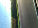
Same at Holden yesterday. Gorgeous color, like 3 shades of blue. Got a few nice 4ft breakers as wellAt carolina Beach for and I'm not sure I've ever seen thr water this color before. This is like some gulf of Mexico turquoise clear water.
Shaggy
Member
Yeah waves have been solid this weekSame at Holden yesterday. Gorgeous color, like 3 shades of blue. Got a few nice 4ft breakers as well
Cad Wedge NC
Member
Wrong thread......With the new climate we have if you went forward 100s of years some places would be desert.
It's summer man no good dynamics to force storms/ rain so you are depending on mesoscale features to force convection. Yesterday over performed because the models under played the mcs moving in from the north and were too slow with its south push. Subsidence in its wake is likely to leave today dry until the next meso feature can force something if at all this evening. Outside of slam dunk situations like stalled fronts, cutoff lows, tropical systems (even here is not always 100%) the day to day forecast in the summer is best left at a 20-30% chance of afternoon stormsWhat is the deal with the busted forecasts lately for storms and rain here?
Last edited:
It's summer man no good dynamics to force storms/ rain so you are depending on mesoscale features to force convection. Yesterday over performed because the models under played the mcs moving in from the north and were too slow with its south push. Subsidence it is wake is likely to leave today dry until the next meso feature can force something if at all this evening. Outside of slam dunk situations like stalled fronts, cutoff lows, tropical systems (even here is not always 100%) the day to day forecast in the summer is best left at a 20-30% chance of afternoon storms
Mesoscale features as well as microclimate influences.
For example, if you're in a lower elevation area prone to downsloping or in a lake/ocean shadow, you're also less likely to see convection.
BHS1975
Member
The coast has the sea-breeze front but even it doesn't produce sometimes.It's summer man no good dynamics to force storms/ rain so you are depending on mesoscale features to force convection. Yesterday over performed because the models under played the mcs moving in from the north and were too slow with its south push. Subsidence in its wake is likely to leave today dry until the next meso feature can force something if at all this evening. Outside of slam dunk situations like stalled fronts, cutoff lows, tropical systems (even here is not always 100%) the day to day forecast in the summer is best left at a 20-30% chance of afternoon storms
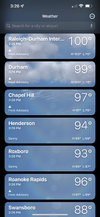
99 at the house, see if we can touch 100 and look like DFW for a day
LickWx
Member
102/73 supposedly at RDU .99 at the house, see if we can touch 100 and look like DFW for a day
You must be looking at WeatherBug. It's only 97 where I'm at.102/73 supposedly at RDU .
Yep. Brr, make sure you bundle up before you go out:102/73 supposedly at RDU .

LickWx
Member
Im sus of 102 but looking at stations seems RDU very likely did hit 100 today.
Yeah, spot checking around central NC and most locations not close to RDU's 102. Maybe some kind of mesohigh or something...Im sus of 102 but looking at stations seems RDU very likely did hit 100 today.
I am too. That 102 would be a six degree jump since the 2:00 observation. I'm not saying it couldn't happen but that is unusual to say the least.Im sus of 102 but looking at stations seems RDU very likely did hit 100 today.
BHS1975
Member
Got hit with jet blast? LolI am too. That 102 would be a six degree jump since the 2:00 observation. I'm not saying it couldn't happen but that is unusual to say the least.
LickWx
Member
I think 100 is plausible just looking around with Goldsboro at 98, Burlington 97, Smithfield 97 but 102 is weird . They did some work at the station a few weeks back been weird since then .I am too. That 102 would be a six degree jump since the 2:00 observation. I'm not saying it couldn't happen but that is unusual to say the least.
BHS1975
Member
My iPhone app is saying 100 for RDU now which is live.Yeah, spot checking around central NC and most locations not close to RDU's 102. Maybe some kind of mesohigh or something...
I am too. That 102 would be a six degree jump since the 2:00 observation. I'm not saying it couldn't happen but that is unusual to say the least.
Might have been a heat burst.
Heat burst - Wikipedia
BHS1975
Member