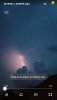
Not a drop of rain here but the lightning is a’plenty!
Yep for about 2 hours straight now
Not close enough!?How accurate is the lightning data points on weather bug? Gotta be fairly close one hit less than one tenth of a mile and it showed up a red circle ?
How accurate is the lightning data points on weather bug? Gotta be fairly close one hit less than one tenth of a mile and it showed up a red circle ?

Probably not. Best chance today is to our west and tomorrow to our east.Well, nothing last night around here. Maybe we'll get some storms today. Not sure what WRAL was talking about yesterday with the chance for severe storms.
Probably not. Best chance today is to our west and tomorrow to our east.
Sent from my SM-G955U using Tapatalk


View attachment 20457
Not a drop of rain here but the lightning is a’plenty!
No, but I've been looking.any recent posters in this thread (i.e., within the last 55 minutes - present company excluded) got a job?
you didn't post in the last 55 minutes ... LOL ... but I still say you'd be one of the best brief writers this planet has ever seen (present company politely excluded) ...No, but I've been looking.

@1300mWhat’s the phone number to the mesoscale discussion center I wanna speak to a manager right now
Thanks, Phil. How's the pay?!! ?you didn't post in the last 55 minutes ... LOL ... but I still say you'd be one of the best brief writers this planet has ever seen (present company politely excluded) ...

it's pretty good, all things considered ...Thanks, Phil. How's the pay?!! ?
Thank-u after a lengthy discussion there is now a meso out for Wilkes and nearby counties.
Must have been a tweet...... hahahaThank-u after a lengthy discussion there is now a meso out for Wilkes and nearby counties.
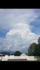
Eyes on the road Jimmy!Headed to the coast. South of Bishopville. #FluffyView attachment 20462
With all the doom and incessant distruction from your end of the world on a minute-by-minute basis, please, please stay far away from the Gulf and Atlantic coasts at least until after November 1st ...Boone mall parking lot is underwater. Some vehicles likely damaged. Mudslides possible western Wilkes. Rescues and pin in are in progress.
Line disconnected by the phone company.
Toooo good!Line disconnected by the phone company.
Yes.. two of the Atlanta TV Mets mentioned it this eveningDecent mcs potential over the weekend into early next week. If we can get storms going Thursday good setup for some severe weather.
Sent from my SM-G955U using Tapatalk
hopefully it trends north east into the western n CarolinaYes.. two of the Atlanta TV Mets mentioned it this evening