• Hello, please take a minute to check out our awesome content, contributed by the wonderful members of our community. We hope you'll add your own thoughts and opinions by making a free account!

Pattern Jarring January

Really hope this verifies in 8-9 days w/ a s/w bulldozing into south-central California and an intense vortex hanging tough in SE Canada and New England. If nothing else, many of us may finally get some precipitation, we're going into a moderate drought in central NC, and we need any rain/snow we can get....
View attachment 2418
That my friends, is a classic split-flow. Could not have drawn it any better.
 
We can work this is if anything remotely close to what the Operational Euro, CMC, Euro control, and EPS verifies, at the very least many of us would at least get some welcome and much needed precipitation

eps_z500a_c_conus_35.png
eps_z500a_conus_35.png eps_t850a_conus_35.png
 
FWIW the eps likes the day 9/10 euro system to slowly slide east through the plains towards the SE


Sent from my iPhone using Tapatalk
 
FWIW the eps likes the day 9/10 euro system to slowly slide east through the plains towards the SE


Sent from my iPhone using Tapatalk

It ain’t worth much with how things have played out lately. While it would be a different setup I’m betting on nothing more then rain.


Sent from my iPhone using Tapatalk
 
FWIW the eps likes the day 9/10 euro system to slowly slide east through the plains towards the SE


Sent from my iPhone using Tapatalk
I still think we will have a nice boardwide event before the winter is over. I just hate we took a step back it seems like.
 
The control in general looks good w/ a beastly 1044 over Washington DC, we just have to hope this s/w doesn't decide to camp out over Baja and Desert southwest or all is lost. Of course I'll be leaving for Austin on the 5th for the AMS conference so it would be my luck to miss a big dog
eps_slp_c_east_41.png
 
gefs_ptype_se_192.png
 
The control in general looks good w/ a beastly 1044 over Washington DC, we just have to hope this s/w doesn't decide to camp out over Baja and Desert southwest or all is lost. Of course I'll be leaving for Austin on the 5th for the AMS conference
Thought you were in new mexico?
i am from Ambequerque yes. Currently I stay at Capstone. I was in Bates house but it was not very nice
 
As was alluded above about the period going forward with the EURO, a nice Snowpack to our Northwest in the Midwest is also modeled. I'm hyped at what's coming. A much better pattern for the entire Southeast than what we currently are going through.

IMG_3337.png
 
Encouraging news if you wanted this winter to keep on chugging after mid January, maybe this year will be one of the few, rare exceptions that have a normal or BN February despite the ongoing NINA. That would be nice.

View attachment 2434

The #1 reason this winter has refused to turn torchy is the big vortex over NE Siberia brought about in part by stronger bgd Indian Ocean forcing and an extensive Siberian snow cover helping to anchor a persist, and very resilient ridge over the Northeastern Pacific and Alaska which continues to flood North America with Siberian air... The extensive snowpack and long-term changes in tropical forcing are 2 big factors not accounted for by classical NINA analogs even if you bin for other phenomena like the EQBO, solar, etc... I certainly will not complain at all.
 
Encouraging news if you wanted this winter to keep on chugging after mid January, maybe this year will be one of the few, rare exceptions that have a normal or BN February despite the ongoing NINA. That would be nice.

View attachment 2434
Seems like the January blowtorch some were hyping, is a no go!
 
If we could just get a -NAO in there somewhere...or an active STJ.
 
I'm not going to call this "historic," because I really do not know. But for my area in NW tennessee, I wonder how long it's been since we have 150+ consecutive hours at or below freezing? That's the forecast, per NWS MEG. Pretty amazing for a southern state with no frozen precipitation on the ground.
 
Brick says the 8-10th storm, is going to be a home run!

GEFS still trying to keep the upper trough off the coast of California, if it follows the EPS and pushes into the southwestern US we're going to probably have a storm, question will be exactly how much cold air we have to work with, given how persistent this vortex has been over the Great Lakes/SE Canada and the deep snowcover to our north, odds are pretty good we'll be at least marginal. Need at least a few more days to figure out the evolution of the trough off of California as that will be key in determining whether a big threat for the entire board actually shows up down the road. This winter is definitely reminding me a lot of 2013-14 where modeled warmth kept showing up in the long range, only to get kicked down the road and we eventually ended up w/ several big events later on in the winter
 
Last edited:
I know I asked for a nice shortwave to crash into California to give us at least some precip but holy crap wasn't expecting this from the GFS. I'm sure there's likely some convective feedback problems here and it's 9 days out so take it for what it's worth, but in any case, a 987 hPa subtropical low is a rarity off southern California aside from big El Nino winters w/ a very stout subtropical jet.
gfs_z500_mslp_namer_37.png

gfs_z500aNorm_namer_37.png
 
I know I asked for a nice shortwave to crash into California to give us at least some precip but holy crap wasn't expecting this from the GFS. I'm sure there's likely some convective feedback problems here and it's 9 days out so take it for what it's worth, but in any case, a 987 hPa subtropical low is a rarity off southern California aside from big El Nino winters w/ a very stout subtropical jet.
View attachment 2439

View attachment 2438

This Winter is trying to defy what we define as La Nina.
 
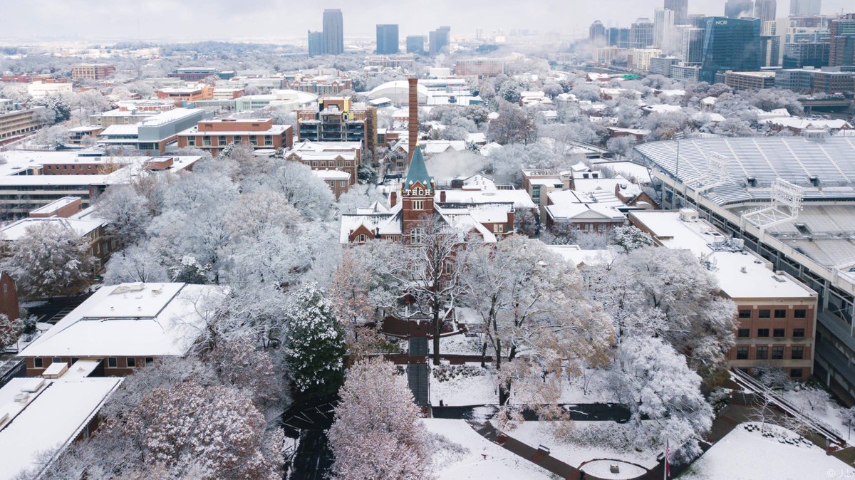
Let us Pray....Cool pic of GA TECH campus on December 9th..Hope we can ALL see this soon....Oh, of course before ground temps and sun angle become an issue, LOL...HAPPY NEW YEAR, hope it is banging for all,,,,,

DQuotrdUQAIOjik.jpg
 
Looks like a pretty cold and boring first few weeks of Jan. Since there is no threat for snow for a while, I may just go back to hibernation.
 
Gonna need it to relax or change to even get a chance of wintry precip up my way. At least its cold but hate wasting it with no snow around.
 
Lol those brutal gfs and cmc cold runs from a few days are a distant memory now


Sent from my iPhone using Tapatalk
Huh...I guess we differ to what cold is in the deep South esp. minus snow cover temperatures for highs I the 20's to mid 30's at best and lows in the teens and even single digits pretty cold for central AL...far north AL highs in the low 20's and lows in the single digits (near 0 in some areas)... To boot wind chills below zero at times... Pretty f'ing cold for this area
 
Lol those brutal gfs and cmc cold runs from a few days are a distant memory now


Sent from my iPhone using Tapatalk

Not a bad thing. I mean, is it really worth the heating cost, static guard cost, and overall horrible feeling conditions? Euro has CAE in the mid 60's next week with 0.8 inches of QPF... of course.
 
Back
Top