We gotta find us a vort/shortwave from somwhere between 1/13-1/27 ish. Thats gonna be the issue. Cold air is there to tap.
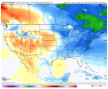
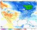
I noticed CFS has whole conus in the Red 1st week Feb, but by 2/3 big west coast ridging and trough back into the east. Ridging gets over the innermtn west, pretty expansive. All CFS is good for is watching the trends from 3+ weeks out. Better off using Webs Mountain Torgue, other TC to guess pattern by then.
No doubt though we got a 2-3 week window here. Just finding the energy to kick off something is our handicap.


")


