tennessee storm
Member
Least we hope not… time will tell. Whole winter everything been laggingNot going back to 6 from what I’m seeing.
Least we hope not… time will tell. Whole winter everything been laggingNot going back to 6 from what I’m seeing.
Gefs gets rid of that annoying MC forcing around day 10, finally a positive trend from yesterday View attachment 98795View attachment 98796
One thing I notice by early jan is ensembles finally have cold air in the western US and even central US and not just in NW can/PNW, all we need is a shakeup at H5 and it can maybe move east, I really like that GFS evolution tho
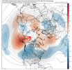
Interesting. Maybe that helped to weaken the SER on the 6Z GEFS after day 10 vs earlier runs.
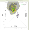
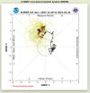
Either one of these is good for the SE in January.It looks like GEFS has found a strong pulse and wants to move. Euro still looks like a nascar race in phase 7. Maybe by the weekend we'll see the light at the end of the tunnel? Or maybe maybe tonight we'll see the oh no we suck again meme....again.
View attachment 98802
View attachment 98803
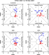
It’s always something. so frustratingI've always been a fan of these RMM component diagrams from Dr Schreck, it gives you nice insight into what's driving the RMM MJO signal. The convective anomalies are in the western hemisphere (phase 8), but U200 (upper-level zonal winds) are highly amplified over phase 6. A large component of this U200 is forced by wave breaking from the subtropics. I.e. the subtropics & mid-latitudes still think we're in RMM phase 6, even though the convective signal is in phase 8. Hence, we're gonna be warm thru late month.
View attachment 98805
It’s always something. so frustrating
I've always been a fan of these RMM component diagrams from Dr Schreck, it gives you nice insight into what's driving the RMM MJO signal. The convective anomalies are in the western hemisphere (phase 8), but U200 (upper-level zonal winds) are highly amplified over phase 6. A large component of this U200 is forced by wave breaking from the subtropics. I.e. the subtropics & mid-latitudes still think we're in RMM phase 6, even though the convective signal is in phase 8. Hence, we're gonna be warm thru late month.
View attachment 98805
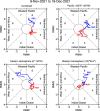
What I'm also saying is if we had the exact same mean RMM, but roles were reversed and U200 was leading the MJO into the W hem instead of OLR, we'd have a much different (more favorable) pattern. The RMM MJO index is nice but it really matters what the individual components are doing, esp U200, because that most strongly reflects onto the mid-latitude circulation pattern.
I know, right. Yet another 3 letter index discovered.It’s always something. so frustrating
Nope.What do we need to look for to get the U200 winds "coupled" with the convection? Any signs of that going forward?
What do we need to look for to get the U200 winds "coupled" with the convection? Any signs of that going forward?
Exactly. Why not just forecast that (U200) instead of the one folks have been following for the past several years. Obviously it means Dittly Squat. The U200 is what affects the 500mb circulation or longwave patterns downstream.What do we need to look for to get the U200 winds "coupled" with the convection? Any signs of that going forward?
