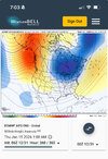
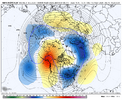
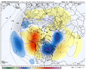
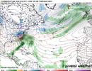
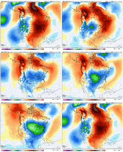
I may be off base but I remember a big GFS bias in years past was to leave those cutoff lows stranded in the eastern pacific? Could this be flaw in the operational model that’s essentially holding the pattern change hostage resulting in that big Conus death ridge and not allowing a true pattern progression? I know we have ensembles for that yada yada but just a thought
-
Hello, please take a minute to check out our awesome content, contributed by the wonderful members of our community. We hope you'll add your own thoughts and opinions by making a free account!
You are using an out of date browser. It may not display this or other websites correctly.
You should upgrade or use an alternative browser.
You should upgrade or use an alternative browser.
Pattern January Joke
- Thread starter SD
- Start date
John1122
Member
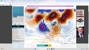
The OP GFS has been doing that all late fall and early winter. It has been retrograding lows from BC down the coast to off Southern Cal. The entire remainder of runs after that are usually off the rails. That's why it's been verifying terribly wrong in the Pac NW, it's been majorly overdoing cold there.I may be off base but I remember a big GFS bias in years past was to leave those cutoff lows stranded in the eastern pacific? Could this be flaw in the operational model that’s essentially holding the pattern change hostage resulting in that big Conus death ridge and not allowing a true pattern progression? I know we have ensembles for that yada yada but just a thought
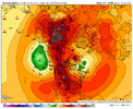
It's probably wrong but possible knowing our luck. That ridge is still kinda near the Aleutians and not poleward enough. Natural reaction downstream is a deep trough on the west coast and pumps a ridge in the east regardless of the west based NAO. But the -NAO is the more dominant feature verbatim so you'd think the low over Hudson Bay would be the more dominant low instead of the one dropped down the west coast. But lately I've learned never to underestimate the SE ability to torch. If its possible we'll figure a way to do itView attachment 180651
How does this happen?
Watch out for potential major Arctic plunges week of 1/19-26: this was released on Tue 12/30.
Exclusive Weather Updates from Vaisala/X Weather & The Weather Co.
Brad Harvey, senior operational meteorologist at Vaisala, says that the forecast for the 6-to 10-day period features much-above-normal temperatures from the West to Texas. Highs are forecast to reach the 50s in Denver, 60s-70s in Dallas, and 70s in Houston. The Midwest and East are forecast to be drier than normal thanks to rounds of high pressure migrating southward from Canada. The forecast is near normal for temperatures in the Upper Midwest and below normal in the East. Risks are mixed for the Upper Midwest, where our forecast takes the middle ground between the warmer GFS and colder ECMWF solutions. Meanwhile, warmer risks in the Rockies are associated with downslope flow, while the Great Basin could be colder under high pressure. The models have lacked consistency in both the 6-to 10-day and 11-to 15-day periods. “The GFS EN projects a –PNA pattern, while ECMWF trends toward a +PNA. Neither of these solutions are given higher favorability, with our forecast featuring a round of above normal temperatures in the Eastern Half and belows emerging late in the Midwest.” For more information, go to https://www.xweather.com/weatherdesk.
Mickey Shuman, a senior meteorologist with The Weather Company, tells us that for most of next week, the Pacific pattern will reverse, helping to drive mild Pacific air into much of western and interior North America. However, a west-based -NAO block will impede the advancement of the mild air into the East. By the 11-to 15-day period, mild Pacific and maritime Atlantic air will overspread the entirety of Canada, essentially shutting down the risk of any major cold air intrusions, such that most of the CONUS moderates and ends up on the warmer side of normal, supporting a prolonged stretch of lower-than-normal GWHDDs. That being said, an emerging +PNA signal also suggests that there won’t be a major or sustainable warm-up and that some seasonably cold air attempts to expand south and east later in the period. The bigger story is the potential pattern change for the middle to end of the month, which could lead to noteworthy cold Arctic blasts over the eastern two-thirds centered on the week of the 19-26th. For more information, go to https://www.weathercompany.com/.
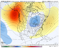
Ehh looks West with the drop.. which is a very slow growing concern in my opinion.0Z EPS 360 looks pretty:
View attachment 180653
Btw, not even a page of post? Ooof haven’t even looked at models yet.
trackersacker
Member
Yeah I’m concerned alsoEhh looks West with the drop.. which is a very slow growing concern in my opinion.
Btw, not even a page of post? Ooof haven’t even looked at models yet.
Brent
Member
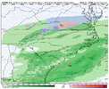
I don't think anyone knows even out here the models aren't that impressive on the snow front despite what the 0z GFS showed at 300 hours (the 6z basically has no snow again haha)
The EPS is a bunch of very light events at most which considering how dry it's been is my concern here(and it still has some showing nothing)
The EPS is a bunch of very light events at most which considering how dry it's been is my concern here(and it still has some showing nothing)
Up early this AM. And yes, I'm also growing concerned that the PNA ridge axis is trending too far west. If so, then we're kicking the can to the post January 20th period, which would leave a month of realistic chances for deep south snowfall.Ehh looks West with the drop.. which is a very slow growing concern in my opinion.
Btw, not even a page of post? Ooof haven’t even looked at models yet.
J1C1111
Member
Yep. That dang clock is starting to tick already. We need a reversal of the models fast to salvage the middle of January. Which could happen the way the swings have been lately. So frustrating.Up early this AM. And yes, I'm also growing concerned that the PNA ridge axis is trending too far west. If so, then we're kicking the can to the post January 20th period, which would leave a month of realistic chances for deep south snowfall.
Sent from my iPhone using Tapatalk
I would hope not. That would be foolish. You can’t dramatically flip like that one day to the next. I really like BAM so I hope that’s not true.I haven’t seen the video or anything, but had a friend send me a text this morning said BamWx was rethinking their forecast. Like I said, I haven’t heard any of the details.
Sent from my iPhone using Tapatalk
rburrel2
Member
NBAcentel
Member
I would hope not. That would be foolish. You can’t dramatically flip like that one day to the next. I really like BAM so I hope that’s not true.
I agree, like I said, I haven’t seen anything. That’s what he sent me. Hopefully, he just jerking me around this morning, but he’s usually not that way.
EDIT: The BamWx comment was not correct. He had not even seen a BamWx update this morning... He was jerking me around. Sorry for the confusion!!!
Sent from my iPhone using Tapatalk
Last edited:
lexxnchloe
Member
CNCsnwfan1210
Member

Overall not a bad evolution of the H5 pattern heading into mid January. Horseshoe style ridge develops over North America aided by the trough over the HI islands and some -EPO to the west, -NAO blocking over Greenland and Atlantic ridge to the east which begins to shift east at the tail end of the run. I think there’s a bias will holding on to the Atlantic ridge too long. Trough begins to develop over central Canada/northern US.
Sent from my iPhone using Tapatalk
I'm honestly not too worried about the ridge axis setting up and anchoring too far to the west. Maybe it happens for a time, but things will oscillate around.
FIRST, we actually have to GET the ridge to go up. IF it is indeed too far west, at least we may get some rain, which we need.
A -NAO could help as well during such a time.
Remember way back when we used to worry about Gulf convection, dry slots, wasting precip evaporating into the air, etc? Boy, those were the days!
I agree here. At worst we’d have to deal with a little WAR if that west coast ridge axis sets up too far west which is always a kick in the nuts but that’s not always bad for WNC or our mid south guys. We can miller B that way. What we definitely can’t have is one that sets up east toward the middle of the country. Unless you like fish stormsI'm honestly not too worried about the ridge axis setting up and anchoring too far to the west. Maybe it happens for a time, but things will oscillate around.
FIRST, we actually have to GET the ridge to go up. IF it is indeed too far west, at least we may get some rain, which we need.
A -NAO could help as well during such a time.
Remember way back when we used to worry about Gulf convection, dry slots, wasting precip evaporating into the air, etc? Boy, those were the days!
Tsappfrog20
Member
I agree, like I said, I haven’t seen anything. That’s what he sent me. Hopefully, he just jerking me around this morning, but he’s usually not that way.
EDIT: The BamWx comment was not correct. He had not even seen a BamWx update this morning... He was jerking me around. Sorry for the confusion!!!
Sent from my iPhone using Tapatalk
Here is an update from BAM just now! Everything still looks good.
Sent from my iPhone using Tapatalk
Fish and ClipsI agree here. At worst we’d have to deal with a little WAR if that west coast ridge axis sets up too far west which is always a kick in the nuts but that’s not always bad for WNC or our mid south guys. We can miller B that way. What we definitely can’t have is one that sets up east toward the middle of the country. Unless you like fish storms
CNCsnwfan1210
Member

Consensus for a fairly strong (~-2 sigma)-EPO around 1/13.
Sent from my iPhone using Tapatalk
Yeah feels like we got some pre-pattern cold feet going on in hereMornin AI looking pretty good-great honestly View attachment 180656View attachment 180661
Now if we start seeing the Pac Jet weaken / not extend as much, that would change things for sure. And getting precip to line up with the cold is a whole different challenge
SnowNiner
Member
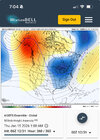
Mornin AI looking pretty good-great honestly View attachment 180656View attachment 180661
Both look really great here, but the Euro I like better because it's got more of that split flow look; and the STJ looks a bit more active undercutting the ridge. It would be cold, but hopefully the STJ keeps firing.
CNCsnwfan1210
Member
Yeah feels like we got some pre-pattern cold feet going on in hereEven the ensemble that has been the farthest west (GEFS) looks classic here at the end for -EPO / +TNH / Alaskan Ridge Regime type cold with Aleutian Low and high pressure lined up from Mongolia to Kansas
Now if we start seeing the Pac Jet weaken / not extend as much, that would change things for sure. And getting precip to line up with the cold is a whole different challenge
View attachment 180664
Straight up connection with the icebox, if that don’t bring the really cold stuff, I don’t know what will.
Sent from my iPhone using Tapatalk
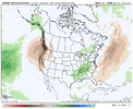
Natural gas, which usually drops when the high pop. centers of the NE US and Midwest look warmer in the 2 week forecast, is down a whopping 5%.
The forecasted -EPO/+TNH cold pattern for the central US eventually looks great for cold domination for folks like Mack, jp, Brent, much of the Midwest, and even getting into the N NE to that guy that moved to ME. But the biggest risk against sustainable cold is in the SE primarily and Mid-Atlantic secondarily, where the SE ridge may be too strong if the PNA in the means doesn’t go positive. This is very difficult to forecast this far out.
Although I don’t like the warmer model developments of recent days for week 2, my hope is still that the PNA in the means will flip for Jan averaged out to match the 100% of -ENSO -PNA Decs since 1983-4 that went to a net +PNA for Jan. My other hope is that the 90 day -PNA bias of the GEFS/EPS/GEPS means that they’re currently off.
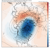
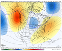
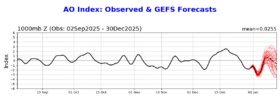
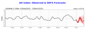
The GEFS AO looks better for midmonth vs yesterday fwiw:
Yesterday:
Today:
The forecasted -EPO/+TNH cold pattern for the central US eventually looks great for cold domination for folks like Mack, jp, Brent, much of the Midwest, and even getting into the N NE to that guy that moved to ME. But the biggest risk against sustainable cold is in the SE primarily and Mid-Atlantic secondarily, where the SE ridge may be too strong if the PNA in the means doesn’t go positive. This is very difficult to forecast this far out.
Although I don’t like the warmer model developments of recent days for week 2, my hope is still that the PNA in the means will flip for Jan averaged out to match the 100% of -ENSO -PNA Decs since 1983-4 that went to a net +PNA for Jan. My other hope is that the 90 day -PNA bias of the GEFS/EPS/GEPS means that they’re currently off.
The GEFS AO looks better for midmonth vs yesterday fwiw:
Yesterday:

Today:

Last edited:
tennessee storm
Member
Think god. We are saving on heating utility bills thus far. Great thing
Spamming a bit here, but just wanted to share these from Paul Roundy - professor (Univ at Albany) who specializes in tropical forcing / climate & weather patterns...
First post here is from Dec 21st when the Euro Weeklies had a stout -PNA pattern showing for all of the 2nd half of January.

Then from yesterday...


First post here is from Dec 21st when the Euro Weeklies had a stout -PNA pattern showing for all of the 2nd half of January.

Then from yesterday...


trackersacker
Member
One of the favored analogs has been 2021-2. This was the GEFS PNA forecast 4 years ago today through Jan 14, 2022: it showed the PNA turning positive, which it did but the mean wasn’t positive enough for midmonth:
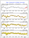
To compare, here’s today’s GEFS PNA forecast, which is clearly going in the right direction at the end but still isn’t then yet a +PNA. Note the wide spread of the members, however:
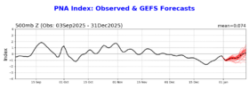

To compare, here’s today’s GEFS PNA forecast, which is clearly going in the right direction at the end but still isn’t then yet a +PNA. Note the wide spread of the members, however:

Last edited:
Let’s also remember that an active STJ helps to keep the SER at bay as well.Both look really great here, but the Euro I like better because it's got more of that split flow look; and the STJ looks a bit more active undercutting the ridge. It would be cold, but hopefully the STJ keeps firing.
CNCsnwfan1210
Member
Spamming a bit here, but just wanted to share these from Paul Roundy - professor (Univ at Albany) who specializes in tropical forcing / climate & weather patterns...
First post here is from Dec 21st when the Euro Weeklies had a stout -PNA pattern showing for all of the 2nd half of January.
View attachment 180668
Then from yesterday...
View attachment 180672
View attachment 180673
When Paul speaks, I listen…
Sent from my iPhone using Tapatalk
CNCsnwfan1210
Member
When Paul speaks, I listen…
Sent from my iPhone using Tapatalk
Nothing against anyone of this forum, because ya’ll are awesome, but this isn’t Paul’s first rodeo.
Sent from my iPhone using Tapatalk
SnowNiner
Member
Spamming a bit here, but just wanted to share these from Paul Roundy - professor (Univ at Albany) who specializes in tropical forcing / climate & weather patterns...
First post here is from Dec 21st when the Euro Weeklies had a stout -PNA pattern showing for all of the 2nd half of January.
View attachment 180668
Then from yesterday...
View attachment 180672
View attachment 180673
I have to admit I'm very confused by the mjo this year. I think forcing means alot for our sensible weather but I'm so confused by how it works. The mjo convection signal has been somewhat dead in the COD for some time now, but we're looking at "mini" rossby waves that are causing convection signals that are making significant impacts on sensible weather? If it's dead why is it making such a difference in the tangible weather?
I do note too he gives us 2 weeks of winter left 1/15 to 1/28.
Ha if we get 2 weeks of decent cold I’d consider that a win really. Who knows on FebI have to admit I'm very confused by the mjo this year. I think forcing means alot for our sensible weather but I'm so confused by how it works. The mjo convection signal has been somewhat dead in the COD for some time now, but we're looking at "mini" rossby waves that are causing convection signals that are making significant impacts on sensible weather? If it's dead why is it making such a difference in the tangible weather?
I do note too he gives us 2 weeks of winter left 1/15 to 1/28.
But yeah, you have varying opinions on how the tropical forcing is working, but at least a piece of it moving east out of the WPac is a good thing. Pressure patterns over Asia always integral too
Sent from my iPhone using Tapatalk

