trackersacker
Member
BREAKING. The bad overnight trends have ended with the Euro 
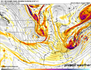
Dang regular Euro did try with first system.1 more of these and we cook. 50/50 low would be super helpful here View attachment 181918


 But so dang close.


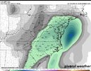
Now we just need for that to fall at a 12 to one rate, lol. It's been so long since I got buried down here. I've had a couple of sleets, like sledding sleets, a horrid zr storm. No power for two weeks. Had several good snows....one ten and a half inches. Really spread out. I'm talking over 30 years since the blizzard. Fun's been scarce. Even the zr horror was in the late 80's. I can't even get what I really don't want anymore, and you used to be able to count on your chances at zr.The total QPF from The NBM is looking good for this weekend! Ukie had almost 4.2" in my area!View attachment 181859
Is that a stinky paper mill kind of smelly coastal fog? That looks like a Hound of the PaperMills kind of fog. Great pic! It's 62 here at 2:30 pm and that's usually a portent for a cold snap and a quick chance at timing....keep that abacus tuned up and humming....or clicking.The dense fog here is the worst I’ve seen anywhere in years and it’s only 9:20PM!
View attachment 181860


HAPPY FRIDAY FAM View attachment 181931
6z Euro AI backed off. Not much precip.AIFS shows something for the weekend.
Not much cold air though

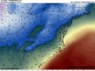
Remember that with warm ground temps, 50% of that is melting on contact if it falls.6z GEFS looks slightly improved at the surface for both systems. As paltry as it is, one of the best snow means we’ve seen recently.
View attachment 181935

Yeah, but we are so far out that this map is a result of some members having nothing and a few with quite a bit more. Too soon to do anything but look for trends.Remember that with warm ground temps, 50% of that is melting on contact if it falls.

Paste bombs favors NE NCOverrunning verse paste bomb suites folks the most.
But imo, #1 , it's eitheir get a phase or get nada. Rooting for a phaser will break more hearts why some win out. But it's the only shot any of us have outside the upslope crowd.
Yep. Check out storm #2 off the 6z GFS.Paste bombs favors NE NC

Virginia special
Thats the 00Z

You need a lot more 0s
Brb posting this to all my socials and calling it a forecast
 ️
️ s on the pond. Potential for the big
  still there. We're solidly in the game, and that's all we need at this point.