Should get some snow if you’re still there tomorrowIn Chicago for work and currently under a flash flood warning.
-
Hello, please take a minute to check out our awesome content, contributed by the wonderful members of our community. We hope you'll add your own thoughts and opinions by making a free account!
You are using an out of date browser. It may not display this or other websites correctly.
You should upgrade or use an alternative browser.
You should upgrade or use an alternative browser.
Pattern January Joke
- Thread starter SD
- Start date
This will potentially choke the La Niña and allow the MJO to more likely move into phase 8 correct?
Typical calculations of MJO RMM Plots are made up of 3 elements and their patterns in the tropics: 850mb wind anomalies, 200mb wind anomalies, and either OLR (cloudiness / convection) or Velocity Potential (upper-level divergence / convergence).
The 850mb wind anomalies on that Euro Wk loop from the linked X post (in yellow and red) show the westerly wind anomalies extending out east of the Dateline coming up after Jan 15. Below are 850mb wind anomaly composites for a few of the MJO phases (image from NOAA). You can ignore the blue and orange coloring - the wind vectors are showing the 850mb wind anomalies. The wind anomalies in that Euro loop match up most closely with Phase 7 below (westerly winds extending out east of the dateline into the central Pacific). Again, this is just one of the 3 components of the MJO RMM calculation. In terms of the MJO running out boldly into Phase 8, we will have to see how that goes in time, but Phase 7 during La Nina combined with the eastward moving warm pool should favor +TNH / -EPO type ridging as long as another factor isn't interfering with that signal

Blue_Ridge_Escarpment
Member
Yeah local news said maybe a sloppy inch between Friday and Saturday.Should get some snow if you’re still there tomorrow

LukeBarrette
im north of 90% of people on here so yeah
Meteorology Student
Member
2024 Supporter
2017-2023 Supporter
Yeah complete swing and a miss. Crazy the run to run differencesThis ICON run ain't digging deep enough for next week's threat
NBAcentel
Member
Welp, when I say it’s just the icon, it happens universally across all models, sooo yeah 
It’s funny that it won’t snow here anymore but the GFS will print out blizzards from Chihuahua Mexico to Pecos Texas
trackersacker
Member
It is true. It’s such a unique model until it does something you don’t like and then suddenly it’s a trend on everythingWelp, when I say it’s just the icon, it happens universally across all models, sooo yeah View attachment 181863
LukeBarrette
im north of 90% of people on here so yeah
Meteorology Student
Member
2024 Supporter
2017-2023 Supporter


Well that’s different.
AI GFS thinks it’s more of a northeast threat
Go take a stroll Downtown and get some pictures. And post for us. You shouldn't have any problems. Plenty of cops up there.In Chicago for work and currently under a flash flood warning.
") Oh, beautiful January night here, frigid 47 degrees.
Oh, beautiful January night here, frigid 47 degrees.NBAcentel
Member

On the second wave, AI GFS moves all the wave energy into the Great Lakes vs into the base of the trough. That will never work

LukeBarrette
im north of 90% of people on here so yeah
Meteorology Student
Member
2024 Supporter
2017-2023 Supporter
OP GFS looking much further east with shortwave
LukeBarrette
im north of 90% of people on here so yeah
Meteorology Student
Member
2024 Supporter
2017-2023 Supporter

New run

Old run
Way different
trackersacker
Member
Here we go with the crappy overnight trends. Mitch just go back to sleep 
Maybe it will help in the 50/50 blocking department for the next oneOn the second wave, AI GFS moves all the wave energy into the Great Lakes vs into the base of the trough. That will never work
View attachment 181868

Euro finishes off its 18z headed for glory. We be cooking by sunrise
accu35
Member
Much colder run for the 15th. May help with the next one
Left some cold dry air behind..maybe it won’t be in vain..but probably
LukeBarrette
im north of 90% of people on here so yeah
Meteorology Student
Member
2024 Supporter
2017-2023 Supporter

It still really tries
Didn’t work out on the first wave with the GFS, but it’s not way off, and it’s a nice look here that’s close to being a cold late bloomer

accu35
Member
Colder air left for round two
oh lawd
LukeBarrette
im north of 90% of people on here so yeah
Meteorology Student
Member
2024 Supporter
2017-2023 Supporter
Trend is clear that it’s trying to show a New England hit. AI GFS did it tooDidn’t work out on the first wave with the GFS, but it’s not way off, and it’s a nice look here that’s close to being a cold late bloomer
View attachment 181874
Right down the ol' stove pipe
LukeBarrette
im north of 90% of people on here so yeah
Meteorology Student
Member
2024 Supporter
2017-2023 Supporter

This should do it!Maybe it will help in the 50/50 blocking department for the next one
This Nantucket’ Nunchuck Nailer!
Should set up a 50/50


2nd wave digging to far into the SW. SE ridging flexing. Brent getting pounded

neutral tilt would prob work. Overall looks goodRight down the ol' stove pipe

But a strong wave and we get ridged out front

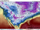
Healthy looking winter storm though
iGRXY
Member
CAD areas could get ice just from looking at the HP running in tandem
accu35
Member

Much better then 18z so far.
accu35
Member
this has a overrunning look to it?