NBAcentel
Member
Probably wasn’t done either, I could see that UL energy in Arkansas re firing up some light snow as it swings towards usJust saw this.... I'm back in!!!!View attachment 63694

Probably wasn’t done either, I could see that UL energy in Arkansas re firing up some light snow as it swings towards usJust saw this.... I'm back in!!!!View attachment 63694
Statesville with the same amount of Charlotte? Not sure if I agree with that
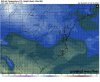
That feature is interesting. If we can have enough lingering moisture that might be able to capitalize on it and give us a couple pockets of snow showers or light snowProbably wasn’t done either, I could see that UL energy in Arkansas re firing up some light snow as it swings towards usView attachment 63695
You got the upper end forecast map?

If it doesn’t shear out just maybeThat feature is interesting. If we can have enough lingering moisture that might be able to capitalize on it and give us a couple pockets of snow showers or light snow


I wouldn’t be surprised to see a advisory issued a little further south. I’m thinking maybe around Hall and Forsyth. Too uncertain beyond there, but at least I think some brief token flakes are a good possibility for our areas.keep moving south. ?
Well Flowery Branch is a 15 min away. I’ll chase it.I wouldn’t be surprised to see a advisory issued a little further south. I’m thinking maybe around Hall and Forsyth. Too uncertain beyond there, but at least I think some brief token flakes are a good possibility for our areas at the least.
Yeah Forsyth and hall are close. I live on Forsyth Dawson line and some models have me at .02 and some have been close to 3”ishI wouldn’t be surprised to see a advisory issued a little further south. I’m thinking maybe around Hall and Forsyth. Too uncertain beyond there, but at least I think some brief token flakes are a good possibility for our areas.
Gotta like the front end shot
Gotta like the front end shot
 Par for the course I guess. I just want to see flakes fly or sleet ping.


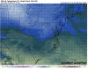
Lol that's brutal. Pretty good evidence of a lull here between the coastal and ull but I'm not sure that the intital shot won't be more impressive than the euro shows but we will be fighting poor thermals. On the bright side we probably end as something that isn't rainEuro shows precip parting like the Red Sea as it approaches our doorstep. ?
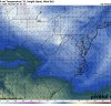
View attachment 63710View attachment 63711
It would imoBrad P. has their Futurecast model up and it’s actually showing what appears to be a period of at least moderate snow from 4pm to 10pm for the whole Charlotte metro area on Friday. What’s odd about it is that the temperatures don’t drop any and stay 36-37 during that time on it. I would have to think that if that band comes through the area like that surface temps would drop a few degrees


Euro shows precip parting like the Red Sea as it approaches our doorstep. ?
View attachment 63710View attachment 63711
Yay front end ripping fatties
Irs very possible with the low transfer. Kind of reminds me of the February storm last yearHRRR is trying to be dry and I’m not buying that.


.png")