Thanks Shawn how about for Santee SC?
Better the further South and East you go. Hell, even Charleston goes over to heavy snow!
Thanks Shawn how about for Santee SC?
You got the frame that shows it right over SC? Sorry for bugging you budRide the 3k NAM to glory folks or off the glorious cliff... but this precip shield at least matches up to th slp fwiw

Sent from my SM-G920V using Tapatalk

I think the accumulation map I posted covers thatYou got the frame that shows it right over SC? Sorry for bugging you bud
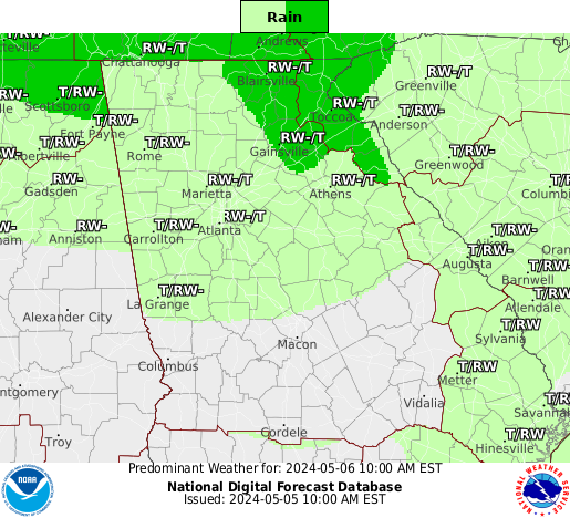
Lol. That's right over ARCC's houseMost (if not all) of the precip showing up on the NAM composite reflectivity map over Alabama and western Georgia would be virga. 3-hour QPF only has a very small area of QPF in east Alabama at hour 21:

Exactly! I will take that and run at this pointThe 3km was actually better than the 6z or 12z runs for RDU
Ride or die!!Exactly! I will take that and run at this point
I'm with youRide or die!!
Yes banter I know... my board
Sent from my SM-G955U using Tapatalk

Still snowing at this point in parts of Central and Northeastern North Carolina as well as Southeastern Va
Sent from my SM-G920V using Tapatalk
Ask those NC guys. Literally, it will be snowing hard 10 minutes away and basically nothing over them. Same will likely happen in this scenario with a very sharp cutoff and dry air.3k wasn't as good for the Midlands.. there is still so much inconsistency on where the Western edge of the precip will set up
FFC is going all in for coverage. Even beyond the models.
Ask those NC guys. Literally, it will be snowing hard 10 minutes away and basically nothing over them. Same will likely happen in this scenario with a very sharp cutoff and dry air.
 So Southern/Eastern Midlands look to do good.
I wouldn't throw the whole Midlands of SC into that opinion. Sumter/Calhoun/Clarendon and most of Orangeburg Co. would do quite well if taken verbatim...3k wasn't as good for the Midlands.. there is still so much inconsistency on where the Western edge of the precip will set up
That storm hurt me more than yall know. To this day, ive still never seen such a sharp cut off from heavy snow to heavy rain and sleet. lolIt happens..... February 2004. Pouring snow in Winnsboro and Newberry, while I had could barely see a few flakes.
Columbia is what I meant.I wouldn't throw the whole Midlands of SC into that opinion. Sumter/Calhoun/Clarendon and most of Orangeburg Co. would do quite well if taken verbatim...
My Area 5 miles North of Santee SC.. looks to in a good area for heavy snow
That looks great for central NC. Didn't expect that. Looks like the totals actually increased.Still snowing at this point in parts of Central and Northeastern North Carolina as well as Southeastern Va
Sent from my SM-G920V using Tapatalk
TBD as far how far enough that precip. field makes it West. I do agree it will be a very tight gradient though. Any subtle changes could make quite a difference for some. Hope it can continue the West shift though.Correct. The Pee Dee (likely, the best spot to be in SC for this storm), Grand Strand, and Lowcountry also look to do well.
Here's the map.Can't post a pic right now but just glancing at the SPC analysis page looks to me like our lead shortwave is still a little Southwest of most model guidance
Sent from my SM-G920V using Tapatalk


Based on that, it appears a hair at most SW. Something looks flatter in the South though compared to the initialized NAM. Any thoughts as to what this could mean? I think that could result in a later tilt, or in other words, it's going east.Here's the map.
Initialized NAM.
It's on tropical tidbits bro.18z Rgem?
Most (if not all) of the precip showing up on the NAM composite reflectivity map over Alabama and western Georgia would be virga. 3-hour QPF only has a very small area of QPF in east Alabama at hour 21:

Based on that, it appears a hair at most SW. Something looks flatter in the South though compared to the initialized NAM. Any thoughts as to what this could mean? I think that could result in a later tilt, or in other words, it's going east.
Also shows upslope snows and flurries for smokey MTNS and favored E TN FWIW;RGEM still had the low in a great position for Central North Carolina but lighter amounts, really starting to think this wound up low is cutting down on the moisture transport west of the center.
Sent from my SM-G920V using Tapatalk


