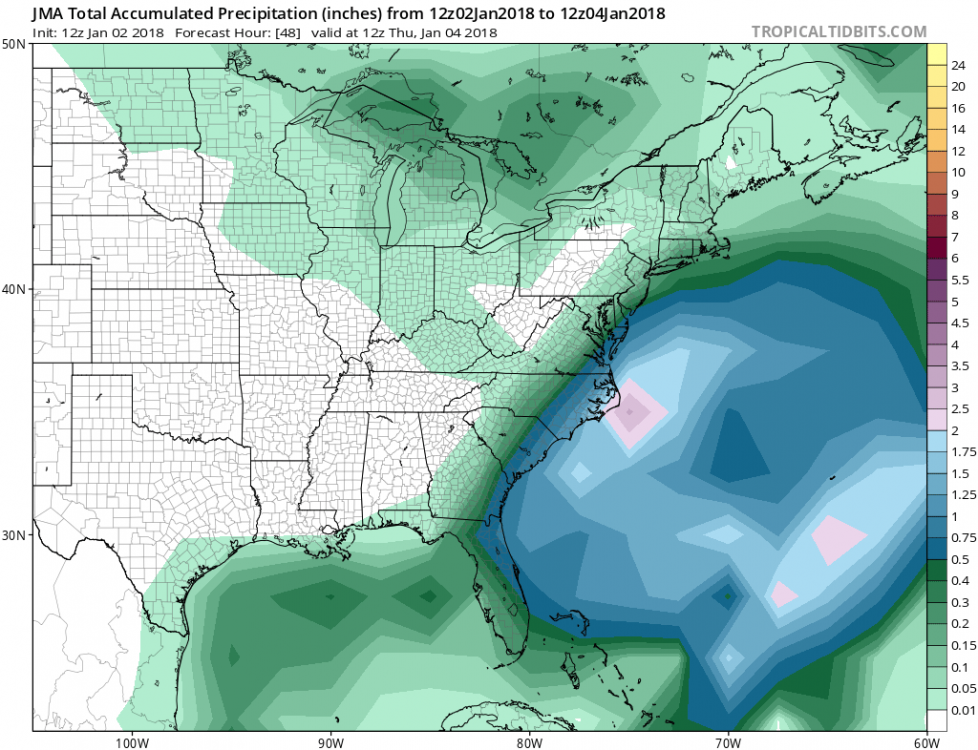
• Hello, please take a minute to check out our awesome content, contributed by the wonderful members of our community. We hope you'll add your own thoughts and opinions by making a free account!

Wintry January 3rd-6th, 2018 Winter Storm The ARCC/Xtreme Weather Special

Thats a great point. And makes sense because it is almost like a developing TC that has competing centers. Given the H5 look, I would expect the SFC low closer to the coast and to develop quicker as well
 
7 nice hits
d8147fa3ba51307250189c374093a052.jpg


Sent from my iPhone using Tapatalk
I see decent hits in Virginia
 
It’s also skewed by the few huge members
I will say that one of those amped up members does get the Triad into the action. Gets close to Charlotte too. I don't recall seeing any other members doing this over the past few days. I would definitely think that Raleigh east towards I-95 should be pretty optimistic after the trends over the past 36 hours.
 
GEFS not very impressed for those of you in interior SC, GA, NC. Darn it!
Not surprised at all . A big win on this storm would be, precip East of 95
 
I’m surprised the 18z gefs didn’t improve given the look at H5 the OP had

My question is how helpful are the ensembles w/this setup? It seems the ops have been leading the way for the most part.


Sent from my iPhone using Tapatalk
 
I've seen a few say the ensembles probably won't be of much help in a phasing situation.

Anyway...let's keep these trends positive at 00z.
 
I think in this situation, the control run (if it phases the systems or not) will have a big impact on the other members. So, I am using them for the idea of the low's location and the precipitation shield as a whole.
 
It's still Saturday night, we still got a good bit of time for the people in the inland areas of the Carolinas. Especially with the continued West trend. If the trend slacks off, then i guess we strike out. I still got faith for sure.
 
What doesn't make sense is how the 18z GEFS mean H5 trough goes neutral tilt faster with a quicker phase than 12z, yet there is less precipitation. However, looking at the individual SLPs tells the story - they are all doing what the operational is it appears by developing the low too far east. Impressively, two are pulled northwest and still slam NC and two more at least get close.
What do you think is causing the two lows?
 
That vort is the result of convective feedback. I took a look at convective precipitation on Dupage and you can see it develops in response to modeled convective precipitation. I am confident the low track will be west and one, consolidated low. If we can get the upper level pattern, the rest will fall in line.

Exactly, this version of the GFS has a notorious sub-vortex scale convective feedback problem which becomes very evident during the hurricane season particularly over the CA monsoon gyre and monsoon trough wherein it creates these spurious diabolically induced eddies which quickly grow upscale and manifest onto the large-scale flow and moisture transport within an incipient tropical disturbance and lead to massive forecast errors in tropical cyclogenesis and intensification even well inside the medium range. I suspect the same issue is occurring here and thus I concur we're likely only going to see one consolidated low here probably further NW where the baroclinicity is highest at the interface of the Gulf Stream and the cooler shelf waters adjacent to the Carolinas and Mid-Atlantic states...
 
Exactly, this version of the GFS has a notorious sub-vortex scale convective feedback problem which becomes very evident during the hurricane season particularly over the CA monsoon gyre and monsoon trough wherein it creates these spurious diabolically induced eddies which quickly grow upscale and manifest onto the large-scale flow and moisture transport within an incipient tropical disturbance and lead to massive forecast errors in tropical cyclogenesis and intensification even well inside the medium range. I suspect the same issue is occurring here and thus I concur we're likely only going to see one consolidated low here probably further NW where the baroclinicity is highest at the interface of the Gulf Stream and the cooler shelf waters adjacent to the Carolinas and Mid-Atlantic states...

And to sum this up everyone, coastal SC/NC/GA would likely be in the game if the surface map was reflected right.
 
Exactly, this version of the GFS has a notorious sub-vortex scale convective feedback problem which becomes very evident during the hurricane season particularly over the CA monsoon gyre and monsoon trough wherein it creates these spurious diabolically induced eddies which quickly grow upscale and manifest onto the large-scale flow and moisture transport within an incipient tropical disturbance and lead to massive forecast errors in tropical cyclogenesis and intensification even well inside the medium range. I suspect the same issue is occurring here and thus I concur we're likely only going to see one consolidated low here probably further NW where the baroclinicity is highest at the interface of the Gulf Stream and the cooler shelf waters adjacent to the Carolinas and Mid-Atlantic states...
Would this feedback issue cause the gefs to produce similar results. Seemed like the gefs should’ve been way west with the H5 look
 
Exactly, this version of the GFS has a notorious sub-vortex scale convective feedback problem which becomes very evident during the hurricane season particularly over the CA monsoon gyre and monsoon trough wherein it creates these spurious diabolically induced eddies which quickly grow upscale and manifest onto the large-scale flow and moisture transport within an incipient tropical disturbance and lead to massive forecast errors in tropical cyclogenesis and intensification even well inside the medium range. I suspect the same issue is occurring here and thus I concur we're likely only going to see one consolidated low here probably further NW where the baroclinicity is highest at the interface of the Gulf Stream and the cooler shelf waters adjacent to the Carolinas and Mid-Atlantic states...
Please dumb down for me? You are like the opposite of bill Nye the science guy
 
The typical NW shift occurred over the last 24 hours after all and it looks to continue. With still over 3 days to go, I wonder how much more NW the track will go. Could it end up too far NW and make it too warm for N FL, SE GA & near the Carolinas' coasts? Opinions?

The 18Z NAM 84 hour maps, wth the low forming just E of S FL, look as sweet as about any I've seen as far as potential history for my area as I think the 90-102 hour maps would have brought significant snow up this way as well as to Stormsfury and quite possibly also something to Phil and Weatherdog.

No matter the final outcome, I'm loving following this to death as there hasn't even been a threat of a significant snow this close in the forecast for here in nearly 30 years, well before I even knew what a wx model was and before internet access for me. Other than the light snow amounts associated with the end of 3/1993, the upper level low of 2/1996, and the rain that turned to snow for only a short period in 2/2010, there has been no measurable SN/IP here since 12/1989, the last time there was a pure or near pure winter storm here. So, I can't help but feel butterflies when considering what COULD happen here. Considering the rarity, I know it could easily end up as very little or nothing. So, my expectations are grounded even though my hope is sky high for now.
 
Back
Top