-
Hello, please take a minute to check out our awesome content, contributed by the wonderful members of our community. We hope you'll add your own thoughts and opinions by making a free account!
You are using an out of date browser. It may not display this or other websites correctly.
You should upgrade or use an alternative browser.
You should upgrade or use an alternative browser.
Wintry January 3rd-6th, 2018 Winter Storm The ARCC/Xtreme Weather Special
- Thread starter TheBatman
- Start date

well, not a good start....
Blue_Ridge_Escarpment
Member
Yep. Definitely odd. Low deeper and closer to the coast. Basically from off JAX to just off MYR and less precip inland. Weird.The low is closer but less precip thrown to the West. Make sense.
Ughhhh! Grenville SC is out!

Later phase, tilt slower. Basically, a step away for interior sections. Still good for the coastal.
The surface low is futher west at hour 39 on Shawn comparison above. LOL
Stormsfury
Member
well, not a good start....
With the later phase, the pull is not as pronounced NW this run...inverted trough is still there, but less warm nosing apparent with a thinner transitional line...
GeorgiaGirl
Member
I think that does it for me. May still be good for interior NC but interior GA outside of South GA is out.
Hard to be mad though about it. It's even rarer for the coast to get anything. What I don't understand is the L was WEST LOL.
Hard to be mad though about it. It's even rarer for the coast to get anything. What I don't understand is the L was WEST LOL.
Yeh confused on why noone is noticing the placement of the low compared to the precip shield.
Cad Wedge NC
Member
Yep, looks that way. I don't understand how it can be stronger and closer to the coast and be less moisture?Yep. Definitely odd. Low deeper and closer to the coast. Basically from off JAX to just off MYR and less precip inland. Weird.
Jon
Member
NAM 3km will be similar. Goodbye insane inland NC snow.
Sent from my iPhone using Tapatalk
Sent from my iPhone using Tapatalk
LovingGulfLows
Member
- Joined
- Jan 5, 2017
- Messages
- 1,499
- Reaction score
- 4,100
Looks like the RGEM. Realistic run IMO.
Webberweather53
Meteorologist
The southern vort intensified and tilted a little faster w/o interaction from the northern stream and the surface low placement is pretty ideal for a big hit between the I-95 and US-1 corridors. A track over or west of Hatteras usually leads to mixing issues in RDU, 50-100 miles offshore is about where you want it here. Just an fyi, the tropical tidbits 12km NAM precip maps also suck.

SnowNotHappen
Member
Ok, so the low placement is CLOSER to the coast, but yet there is less precip inland?? Why?
Webberweather53
Meteorologist
NAM 3km will be similar. Goodbye insane inland NC snow.
Sent from my iPhone using Tapatalk
The TT 12km NAM reflectivity maps are bad, there's still snow into the eastern piedmont of NC on this run verbatim
Attachments
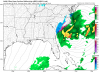
Got a pic, Eric? If you don't mind?The TT 12km NAM reflectivity maps are bad, there's still snow into the eastern piedmont of NC on this run verbatim
00z NAM:

18z NAM:

18z NAM:
B
Brick Tamland
Guest
No, just hate when people say one run different from the other runs is a trend. One run is not the definition of the word trend.Ok, wait till 6z then. It doesn’t mean we can’t get snow. You’re too emotional about this. There are still plenty of snow scenarios on the table. It would be nice for a global to show some of them.
Snowflowxxl
Member
No way to sugar coat it, not a good run!
packfan98
Moderator
Agreed. It would be more accurate to say that the nam took a step towards the other models.No, just hate when people say one run different from the other runs is a trend. One run is not the definition of the word trend.
BHS1975
Member
No way to sugar coat it, not a good run!
We toss
Sent from my iPhone using Tapatalk
Whats funny is the sfc low is closer to the coast yet less precip....ya....there is no easy way to say this, but what changes on the NAM both 12km and 3km and not in a good way....NAM=FAIL this run for sure.With the later phase, the pull is not as pronounced NW this run...inverted trough is still there, but less warm nosing apparent with a thinner transitional line...
Last frame is the newest. Much further East with precip shield for GA/SC especially. This is like 4 NAM runs.

Cary_Snow95
Member
It would be classic if the gfs came in like the nam now
That’s semantics. The bottom line is, the early phase that the Nam was showing that was absent on all the other models is gone. That tells me that the Nam was probably wrong. That isn’t Debbie Downer. It’s just an unfortunate fact.Agreed. It would be more accurate to say that the nam took a step towards the other models.
Yep, big change within hours of the players both being on the field in the continental usa. Sorry my KCAE/GA friends.
Jon pointed it out clearly. The trailing wave got held up by the GL vort . See if that's the case rest of tonight in to tommorow.
Actually 3km is good for NC and thats about it...even GA and SC coastlines...forget about inland GA and SC this run
Stormsfury
Member
Whats funny is the sfc low is closer to the coast yet less precip....ya....there is no easy way to say this, but what changes on the NAM both 12km and 3km and not in a good way....NAM=FAIL this run for sure.
Funny thing is that the globals could continue a slight west adjustment...there was a key difference on this run, though, so I wonder how that will affect the 00z suite. Definitely though, NAM trended towards the EURO and looks more like the RGEM in some aspects.
It will be interesting to see if the globals have a stronger lead wave, how will they respond at the SFC tonight
in NC it's all about sfc lp track. Yea a super jacked up lp is nice but a weaker one hugging the SC coast and on a more north trajectory will get enough qpf to whiten the brown ground.Actually 3km is good for NC and thats about it...even GA and SC coastlines...forget about inland GA and SC this run
Stormsfury
Member
Last frame is the newest. Much further East with precip shield for GA/SC especially. This is like 4 NAM runs.
Well you can definitely see it consolidated quite a line of convection over the Gulf Stream on the 00z run... part of your moisture transport problem
The overall setup still look decent for the us1 area east.
Sent from my SM-G955U using Tapatalk
Sent from my SM-G955U using Tapatalk
I'm riding the 3k NAM to glory or the glorious cliff...

00z:

18z:

18z:
Yep a good run and highlights the snow 9n the NW side much better.I'm riding the 3k NAM to glory or the glorious cliff...
Sent from my SM-G955U using Tapatalk
I hope it works for y'all for sureYep a good run and highlights the snow 9n the NW side much better.
Sent from my SM-G955U using Tapatalk
Don't get me wrong still a very hard hit for NFL and the coastal areas of GA and SC. Just not as much
Wow, that's a huge shift East. How depressing.Last frame is the newest. Much further East with precip shield for GA/SC especially. This is like 4 NAM runs.
packfan98
Moderator
3k nam looks great for the eastern nc Piedmont. Some totals over a foot. Over 10” for Raleigh. We toss?
Brett
Member
Looks great, 5" where I live and still3k nam looks great for the eastern nc Piedmont. Some totals over a foot. Over 10” for Raleigh. We toss?
Snowing should be a decent storm