Brett
Member
If I get what the euro shows I'll be above avg. I avg 5" a year in SE Va let the trends continue
Reasonably speaking, I have never seen a winter in which we get a large storm and then an even larger one. The only exception is maybe 2010 and 2011.Wow, writing off winter before we even get in Jan? Interesting. I mean I’m playing with house money as I have already gone beyond my average annual snowfall, but I’m greedy!
Jesus Christ, really man? It’s NYE for God’s sakeWe would have to have a complete failure of the Euro on the 500MB level and a different setup for a sudden shift like that. 0.00001% chance that happens. I say next winter! We're done here in N GA for large storms this year.
My goodness if the Euro had the phasing energy more consolidated on the map Webb posted earlier that would have been a monster....WOOF
So I take it you’re liking RDUs chance with the nw trend. I’m trying to temper my excitement.. for nowI could see this legitimately trending as far west as Charlotte or Greensboro in NC but west of there I wouldn't given this much credence atm
The piece of energy have been phasing sooner and west each of the model runs.That's before even the sampling of the energy,which will be sampled tomorrow morning.I believe that Northern Georgia,Most of Alabama,central and Upstate South Carolina and maybe even Western North Carolina still have a shot .We are still 78-84 hours away from the system and systems trend west as we get closer.THANK YOU for giving reason here. That should end the wishcasting for us up here and over here in AL, N GA, and Upstate SC as well as W NC. It's dry completely between the DGZ and surface, so everything should evaporate.
We would have to have a complete failure of the Euro on the 500MB level and a different setup for a sudden shift like that. 0.00001% chance that happens. I say next winter! We're done here in N GA for large storms this year.

I like the potential of the players we have on the field but like you I am trying to keep expectations in check. It would be just as easy to see 2-4 inches of snow as it would full sun with a stratus deck on the eastern horizonSo I take it you’re liking RDUs chance with the nw trend. I’m trying to temper my excitement.. for now
The realistic best case scenario for this imo would be a flizzard to maybe a dusting in CLT-GSO with increasing amounts as you go east to the coastal plain. I'm not holding out much hope for this storm for my backyard but it's still fun tracking it.I could see this legitimately trending as far west as Charlotte or Greensboro in NC but west of there I wouldn't given this much credence atm
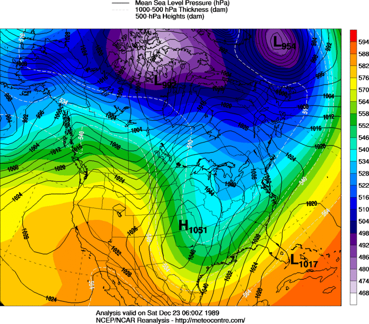
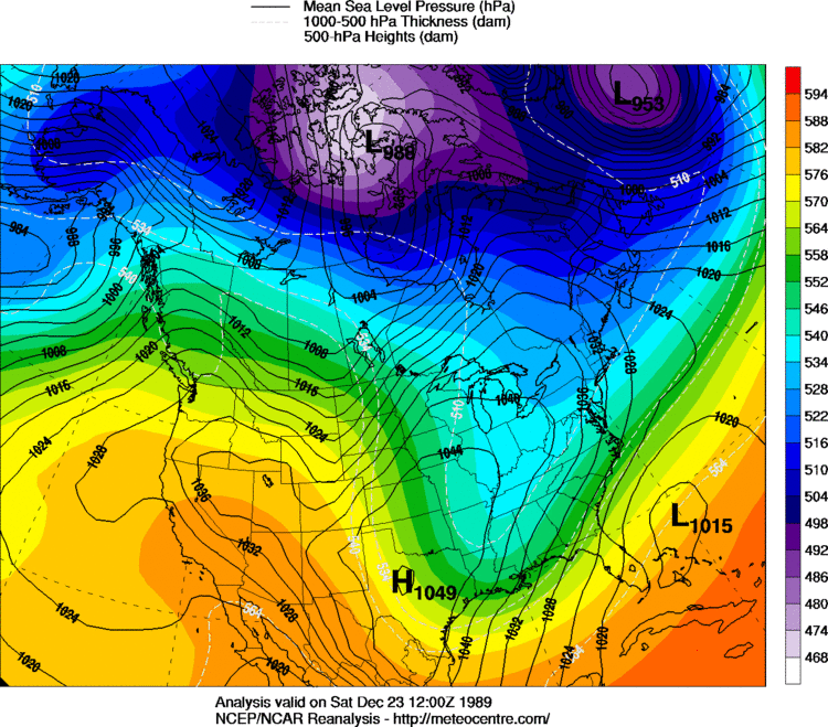
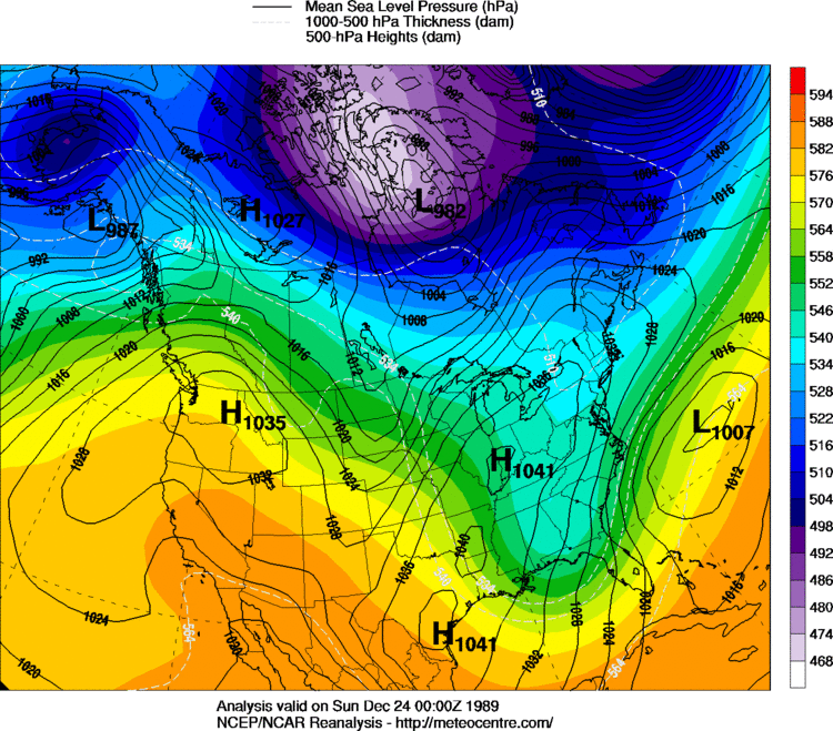
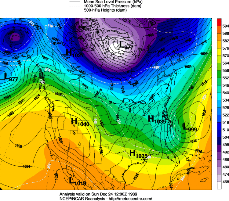
Storm...We'd need a phase to occur around Arkansas or Miss to help the interior portions of SC ,correct? I can't wait till our wave enters the US and we can get better model samples.Also as the 1989 event trough went NEG tilt, look what happened at the SFC low ...
Absolutely started deepening rapidly and retrograded a bit as the occlusion started taking place by then..
I believe the system could trend west enough to the point where the coast get nothing besides rain and maybe flurries on the backside.This system is becoming much more like January of 2000 and 1940 then December of 1989 by seeing the recent trends with the energy and storm track.I may be wrong in this statement, but I think that it actually snowed in places like Panama City and Pensacola, FL in 1989 before South Georgia/Coastal Carolinas got clobbered. It doesn't appear that such a thing will transpire in this situation unless this system really blossoms to the west.
I may be wrong in this statement, but I think that it actually snowed in places like Panama City and Pensacola, FL in 1989 before South Georgia/Coastal Carolinas got clobbered. It doesn't appear that such a thing will transpire in this situation unless this system really blossoms to the west.
Storm...We'd need a phase to occur around Arkansas or Miss to help the interior portions of SC ,correct? I can't wait till our wave enters the US and we can get better model samples.
Ummm the new NAVGEM is amaze balls. I can’t unsee it. Low gets tucked in near the coast

I agree!**IF that does indeed happen, probably have to look at a readjustment in the Miami low closer off Central FL coast which of course, follows more closely with the GS ... plus historically that's prime SFC low positions for significant Eastern Carolinas and SE GA snowfalls.
I agree!
I have no recollection of the event at all due to being only two, but the snow in Georgia stopped thirty miles south of my location and my father told me on numerous occasions that the only thing that anyone was calling for was just intense cold to occur. With this situation, I completely agree that the QPF field would possibly be more north.It did. We had a couple of precursor events as well much like Thursday night's light ice event and potential for later today/tonight.
My reanalysis comparisons above to our setup now makes me believe more are in the game this time compared to 1989
GaWX or anyone else with an extensive storm history knowledge, has there ever been an event historically similar to the one that occurred in December 1989? I've looked before, but have never found anything remotely similar to the final snowfall maps or weather conditions that prompted the storm.

I have no recollection of the event at all due to being only two, but the snow in Georgia stopped thirty miles south of my location and my father told me on numerous occasions that the only thing that anyone was calling for was just intense cold to occur. With this situation, I completely agree that the QPF field would possibly be more north.
It did. We had a couple of precursor events as well much like Thursday night's light ice event and potential for later today/tonight.
My reanalysis comparisons above to our setup now makes me believe more are in the game this time compared to 1989
Much the same down here; sleet, freezing rain, a good glaze and then it snowed from very early AM until late mid-afternoon; ended up with about an inch and a half of frozen water with snow on top. It never showed on any TV or newspaper forecast (internet was infant then) and during the event our local NWS, radio and TV were clueless ...That Friday nothing was in the forecast. It clouded up here in my area (just NW of North Charleston)... then a couple of hours before sleet started ay 6pm that night in the 22nd, quickly changing to snow 630pm. Forecast 1" .. then 1-3" ... every cycle forecasted more as the event kept intensifying. It was catch up forecasts throughout the event
The recent trends with the Phase occurring faster and further west(before the energy is even sampled) could actually take the coast of South Carolina and North Carolina out of the game for snow. I could actually see Most of Alabama,most of Georgia,most of South Carolina actually getting snow with this system.This mid week system is looking more like January of 2000 and 1940 then December of 1989.
Three days away is still a lot of time.There have been systems that have trend well west before within the three day range and with the phasing concurring earlier and further west, could give most of Alabama,Northern Georgia,Upstate South Carolina and Western North Carolina a snow event.We have seen many systems tend much further northwest as we get closer and I see no reason this would be different.Except...we're a few days away from go time. This would have reason if we were 5 days away but we're 3 days away and everything involved with this is going to be sampled pretty good soon. I think this can get further west but not too much further.
True we do see NW trends at times but that energy is gonna have to keep on driving big jumps west ever run and keep that interaction with secondary wave to be able to get a low on the west coast of GThree days away is still a lot of time.There have been systems that have trend well west before within the three day range and with the phasing concurring earlier and further west, could give most of Alabama,Northern Georgia,Upstate South Carolina and Western North Carolina a snow event.We have seen many systems tend much further northwest as we get closer and I see no reason this would be different.
I think Dec 1989 is the closest we have compared to everything else. Practically all our other hits are from s/w entering California
I think Dec 1989 is the closest we have compared to everything else. Practically all our other hits are from s/w entering California

