Webberweather53
Meteorologist
Lol I should have known better than to get sucked in to this mess. If the next 2 suites look as bad or worse, I'll retreat back to the dark, pessimistic side.
So this could be a one time error? No?
Bottom line is tonight, a vorticity spike off the Hudson Bay Vortex altered our trailer wave enough for a totally different result... chaos theory and butterfly effect.
Lol I should have known better than to get sucked in to this mess. If the next 2 suites look as bad or worse, I'll retreat back to the dark, pessimistic side.
Well if it goes to pot , we'll just have to settle for chasing the cmc stupid Cold this week. Hope you saved that run lol. Not a good trend with our trailer wave on 0z.

Lol I should have known better than to get sucked in to this mess. If the next 2 suites look as bad or worse, I'll retreat back to the dark, pessimistic side.

Poo train leaves 2 eastern tomorrow afternoon . I’ll see you there
Can I buy my ticket now? How much?
Sent from my iPhone using Tapatalk
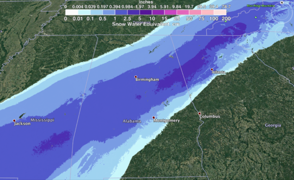
The SC total is deceiving, that actually comes tomorrow night into Monday Morning.Even the apparent westerly-biased german model hardly brings any snow inland over the Carolinas. Rip.
View attachment 2478

It really was. I have to admit.. this chase for a storm seems more thrilling than others we've been on because of the potential. Even though it's frustrating, it was kinda thrilling at the prospect.It was a long shot anyways. The idea of all the modeling, even the UKMET being a no go, should be a major sign.
No offense, but we just don't see this having any dramatic change in such a sort period of time to produce much, if anything, of a winter storm.So, after just being very optimistic, now all of the sudden people are giving up? What's with the wild swings? It will be hilarious if the Euro is as good or better than its 12Z run or if the 6Z/12Z runs are better.
Earlier, the Euro had precip here (almost an inch) and the highs were in the mid 60s.I guess we have to a more moisture producing storm and hope we have enough cold air to produce later. But honestly, kicking this can is getting tiresome. Hopefully, what Eric alluded to can do the trick if this threat fails. We'll live you guys. Just try to start off fresh for the new year and let's learn from this.
So, after just being very optimistic, now all of the sudden people are giving up? What's with the wild swings? It will be hilarious if the Euro is as good or better than its 12Z run or if the 6Z/12Z runs are better.
Yeah, the warmth ruining our chances with the California shortwave is what I was afraid of. But I guess the cold can come back strong but who knows? May be over till next winter. Maybe we'll get another chance but not in the foreseeable future.Earlier, the Euro had precip here (almost an inch) and the highs were in the mid 60s.

That's not even remotely similar to ground truth.Right