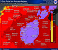
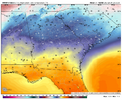
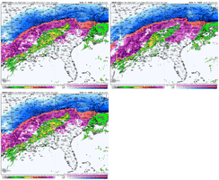
How is now cast trending against the models?Just look at the old model runs for yourself. The models that have that convection and race it farther to the east… lead to more initial precip in central SC/eastern NC early on.
The hi-res models that were bone dry don’t have that convection racing east… and all the precip streams in a perfect curve as far north and west of us as possible, limiting the southern edge.
-
Hello, please take a minute to check out our awesome content, contributed by the wonderful members of our community. We hope you'll add your own thoughts and opinions by making a free account!
You are using an out of date browser. It may not display this or other websites correctly.
You should upgrade or use an alternative browser.
You should upgrade or use an alternative browser.
Wintry January 23rd-27th 2026
- Thread starter SD
- Start date
rburrel2
Member
It looks good for some precip getting in to Augusta/columbia/charlotte early on, imo. More like the euro/gfs and less like those very dry hi-res model runs. The hrrr is coming in wetter as well at the end of its range now.How is now cast trending against the models?
WxBlue
Meteorologist
MichaelJ
Member
Currently in W-S, 24/3. At my house in Lewisville it is 22/2
Seems like the nws maps go up and down with no real explanation
They are based off of NBM and then the mets tweak them, changes in the NBM can shift it around.Seems like the nws maps go up and down with no real explanation
RDU is 25 / -9 as of 1pm! WOW, those insane DPs have turned out!
Wet bulb is 19! Good chance we do see the teens modeled verify!
Wet bulb is 19! Good chance we do see the teens modeled verify!
WolfpackHomer91
Member
I mean they just issued a slight risk for the Deep South for tomorrow. I think there is a real risk the Gulf storms rob some moisture from the Carolinas. But who knows, we will see.
Let’s point em SW - NE and double it ….. ducks for cover
Sent from my iPhone using Tapatalk
Iceagewhereartthou
Member
Yes. It seems like path of least resistance would be to track East towards FL, not plunging straight into them. Weather can be hard to figure!Truly insane that the low is gonna slam right into the HP and keep rolling.
Yall please post your church and school cancellation posts in the banter thread. Please…
Makeitsnow
Member
blueheronNC
Member
Not a fan of the lighter precip totals. Could be more efficient glazing accrual in those extremely low tempsRDU is 25 / -9 as of 1pm! WOW, those insane DPs have turned out!
Wet bulb is 19! Good chance we do see the teens modeled verify!
RDU is 25 / -9 as of 1pm! WOW, those insane DPs have turned out!
Wet bulb is 19! Good chance we do see the teens modeled verify!
Of note, this is exactly what the 12z HRRR had at RDU for 18z (1pm), so that’s a feather in its cap.
Epps home depot got a huge shipment of generators last night, went there this morning for some plumbing bits and every one of the generators is gone.Welp. Back to Home Depot…
Currently rocking low/mid 40s like most of us around north central GA & west central SC. The cold is coming, will be watching how quick it builds down from VA this afternoon into evening.
LongRanger
Member
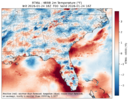
That's dead on pretty much here my upstate location. I'm sitting at 39hrrr is going to bust on temps in sc and here. In sc, temps are 36/37 at in the gsp area to 39 in greeenwood compared to this by the hrrr. with strong caa underway, not going to happen. That will likely stranslate to colder temps tonight after wetbulbing.
View attachment 188574
Anyone have that US power outage map?
Anyone have that US power outage map?
United States Power Outage Map
PowerOutage.us is an ongoing project created to track, record, and aggregate power outages across the United States.
Blue_Ridge_Escarpment
Member
Light precip falling in Morganton on I-40
Avalanche
Member
Brown Mountain?Light precip falling in Morganton on I-40
WolfpackHomer91
Member
Sent from my iPhone using Tapatalk
After the initial precipitation tonight, most models do show a dry slot for tomorrow. By tomorrow morning this is what the RAP has for total QPF (up to hour 21):
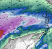
Much of that has fallen as sleet over northern NC.
Below is the simulated radar on the last frame (hour 21):
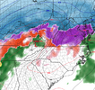
Temps at hour 21:
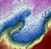
Looking at soundings many (most areas) below freezing are still receiving freezing rain/drizzle, even as the simulated radar (precip types) shows nothing.

Much of that has fallen as sleet over northern NC.
Below is the simulated radar on the last frame (hour 21):

Temps at hour 21:

Looking at soundings many (most areas) below freezing are still receiving freezing rain/drizzle, even as the simulated radar (precip types) shows nothing.
TigerSnow
Member
I think that was the concern of some Mets. Even though it shows a dry slot we might still having freezing drizzle that would accumulate efficiently.After the initial precipitation tonight, most models do show a dry slot for tomorrow. By tomorrow morning this is what the RAP has for total QPF (up to hour 21):
View attachment 188576
Much of that has fallen as sleet over northern NC.
Below is the simulated radar on the last frame (hour 21):
View attachment 188577
Temps at hour 21:
View attachment 188580
Looking at soundings many (most areas) below freezing are still receiving freezing rain/drizzle, even as the simulated radar (precip types) shows nothing.
You can also sign up for text/email updates as well.
United States Power Outage Map
PowerOutage.us is an ongoing project created to track, record, and aggregate power outages across the United States.poweroutage.us
VegasEagle
Member
Does anybody have reports from the Memphis area?
18Z GSO sounding
Based on real-time regional radar, I'm 100% certain that the meager QPF modeled through the Atlanta/Athens area is dramatically underdone. If it has the temps within the CAD correct, then that's going to be a problem for those who dislike an ice storm.After the initial precipitation tonight, most models do show a dry slot for tomorrow. By tomorrow morning this is what the RAP has for total QPF (up to hour 21):
View attachment 188576
Much of that has fallen as sleet over northern NC.
Below is the simulated radar on the last frame (hour 21):
View attachment 188577
Temps at hour 21:
View attachment 188580
Looking at soundings many (most areas) below freezing are still receiving freezing rain/drizzle, even as the simulated radar (precip types) shows nothing.
iGRXY
Member
HRRR is slower this run. But if you look at the real time radar you’re starting to see the SE flow streamers forming over Alabama
iGRXY
Member
Blue_Ridge_Escarpment
Member
That will just continue up until hour 1.View attachment 188591
This looks even better moisture wise vs 12z
Webberweather53
Meteorologist
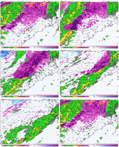
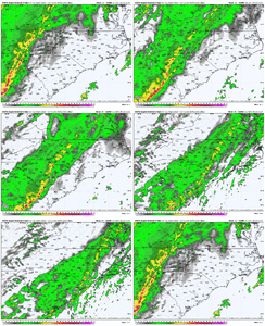
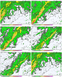
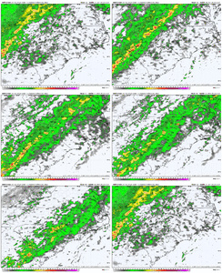
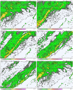
The thing that still concerns me the most with this ice storm in the Carolinas is the squall line of heavy freezing rain showers and elevated supercells that comes at the tail end of this storm late Sunday evening into Sunday night.
Gusty winds from these could lead to widespread downed trees and power lines in areas that have significant ice accumulation left on the trees and power lines. This is more likely to be the case over the Piedmont in places like Raleigh & Charlotte down to Greenville-Spartanburg and even near the Triad. If your power goes out during this ice storm, the arrival of these gusty showers and embedded supercells is most likely when it will happen
Basically every high resolution CAM shows this scenario playing out, including the RRFS, NAM, HRRR, FV3, and ARW


rburrel2
Member
12z rgem is finally running. Looks a little colder and wetter for the upstate through sunday morning.
Edit: actually a little drier later in the morning.
Edit: actually a little drier later in the morning.
iGRXY
Member
The thing I’m noting with the short range models is they’re correcting wetter in the short range. As they extend that’s where they’re drier. Again, even in their dry hours we will see precipitation that accrues very efficiently. I still think like most Mets we will continue to see these short range models fill in more and more
Did NWS Atlanta do a briefing today? If so, any nuggets you pulled from it?
In the heaviest areas and convection could you switch to sleet?The thing that still concerns me the most with this ice storm in the Carolinas is the squall line of heavy freezing rain showers and elevated supercells that comes at the tail end of this storm late Sunday evening into Sunday night.
Gusty winds from these could lead to widespread downed trees and power lines in areas that have significant ice accumulation left on the trees and power lines. This is more likely to be the case over the Piedmont in places like Raleigh & Charlotte down to Greenville-Spartanburg and even near the Triad. If your power goes out during this ice storm, the arrival of these gusty showers and embedded supercells is most likely when it will happen
Basically every high resolution CAM shows this scenario playing out, including the RRFS, NAM, HRRR, FV3, and ARW
View attachment 188586
View attachment 188589
View attachment 188590
View attachment 188592
View attachment 188593
Webberweather53
Meteorologist
In the heaviest areas and convection could you switch to sleet?
You actually could see a variety of precipitation types in the heaviest showers. Anything from all rain, to freezing rain, sleet, graupel, or even hail

