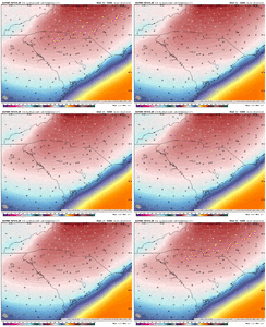
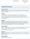
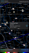
I knew we’re all hung up the details of ptype and QPF (including me), but just wanted to point out this storm will be a fascinating battle of a crazy strong classic CAD vs incredible warming aloft. It’s like watching an all time defense against a top rated offense in football.
-
Hello, please take a minute to check out our awesome content, contributed by the wonderful members of our community. We hope you'll add your own thoughts and opinions by making a free account!
You are using an out of date browser. It may not display this or other websites correctly.
You should upgrade or use an alternative browser.
You should upgrade or use an alternative browser.
Wintry January 23rd-27th 2026
- Thread starter SD
- Start date
Webberweather53
Meteorologist
iGRXY
Member
Thank you lol. The 3K is 2 degrees too warm at the surface and not dry enough at the +5 on the DP. Struggling isn’t the wordSome of yall with this mess that the wedge is underperforming.
You are not serious people.
iGRXY
Member
The most recent HRRR is +4 on the DP right now. Even the short range models aren’t handling the low level cold air or dryness wellThank you lol. The 3K is 2 degrees too warm at the surface and not dry enough at the +5 on the DP. Struggling isn’t the word
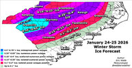
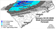
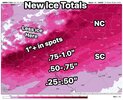
You don’t see anywhere over an inch ?Final forecast maps for this upcoming winter storm.
Tough one in the Carolinas.
View attachment 188547
View attachment 188548
Mpirone12
Member
Who is focusing on it? Just sharing model output, which for central NC is not a stretch considering dry slot. These comments are what irritate posters. Oh and look NAM very similar
View attachment 188545
Apologies man. You are one of the extremely knowledgeable posters. That wasn’t directed at you. More so I was just saying overall dont focus on one specific model right now but real time. My bad if it came across that way!
Sent from my iPhone using Tapatalk
Webberweather53
Meteorologist
You don’t see anywhere over an inch ?
If anyone gets an inch of ice, it's most likely going to be along the Blue Ridge Escarpment between Greenville and Asheville.
Bruh
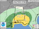
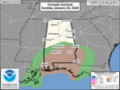
I mean they just issued a slight risk for the Deep South for tomorrow. I think there is a real risk the Gulf storms rob some moisture from the Carolinas. But who knows, we will see.
rburrel2
Member
Sounds a lot like 2015. That’s how that model bust started… us noticing temps/dews weren’t lining up about 8 hours prior to event start time.The most recent HRRR is +4 on the DP right now. Even the short range models aren’t handling the low level cold air or dryness well
Blue_Ridge_Escarpment
Member
Depends on orientation of it in the gulf. Could enhance.I mean they just issued a slight risk for the Deep South for tomorrow. I think there is a real risk the Gulf storms rob some moisture from the Carolinas. But who knows, we will see.
I can’t
Also lighter precipitation better zr accrual
rburrel2
Member
Well I do think regardless, it's introduced a convective element to things tomorrow.Depends on orientation of it in the gulf. Could enhance.
Last edited:
Novice here in Athens, Ga. 3 small kids in an apartment. Father in law lives 20 miles south in Madison ga ( Morgan county). Trying to figure out if we need to pack up everything and the kids and stay with the in laws. They have fireplace and generator. Initially it looked like impacts could be significant in Athens, possibly even further south in Morgan county. Sees like all the latest forecast and trends are really downplaying the potential ice accumulation in these areas. NWS still advising .25 to 1 inch. Any advice on what we should do or the expectation on these areas?
billyweather
Member
Truly insane that the low is gonna slam right into the HP and keep rolling.
If I sent you this exact picture in NW Piedmont NC in like 2002 you’d have to be thinking smash job… the two HP the Texas / OK / AR Hammer …. Used to all be tell tells
Sent from my iPhone using Tapatalk
Mpirone12
Member
I don’t know this answer but maybe a knowledgeable poster can chime in. I know in the past storms have happened that took some moisture away but I remember seeing by a lot of people yesterday that if storms do pop up in the gulf with this specific storm it has a strong possibility to enhance moisture upstream.
Sent from my iPhone using Tapatalk
Sent from my iPhone using Tapatalk
Yeah. It’s one of those things we just don’t know until storms are firing and we see how they’re oriented. As I remember Matthew East saying once, every winter storm in the Upper southeast thunderstorms in the gulfDepends on orientation of it in the gulf. Could enhance.
Dang. Not a good start 
iGRXY
Member
Sw to Ne configured thunderstorms is good and enhanced moisture retrieval. Conveective thunderstorms that are west to west are bad. They cutoff moisture from moving north
I think it has slightly more scientific reasoning than other boogeymen but tbh unless Tallahassee has flash flood warnings for training supercells I don’t really think about this very muchI don’t know this answer but maybe a knowledgeable poster can chime in. I know in the past storms have happened that took some moisture away but I remember seeing by a lot of people yesterday that if storms do pop up in the gulf with this specific storm it has a strong possibility to enhance moisture upstream.
Sent from my iPhone using Tapatalk
Somebody on here is gonna see all 4 precip types with this one (snow/ip/frz rn, rain), but will anyone see all those types and thunder in the same event? lol
Ron Burgundy
Member
If you have 3 small kids in an apt in Athens it’s a no-brainer to go to your in-laws. No matter how “in-law-ry” your in-laws areNovice here in Athens, Ga. 3 small kids in an apartment. Father in law lives 20 miles south in Madison ga ( Morgan county). Trying to figure out if we need to pack up everything and the kids and stay with the in laws. They have fireplace and generator. Initially it looked like impacts could be significant in Athens, possibly even further south in Morgan county. Sees like all the latest forecast and trends are really downplaying the potential ice accumulation in these areas. NWS still advising .25 to 1 inch. Any advice on what we should do or the expectation on these areas?
Darklordsuperstorm
Member
rburrel2
Member
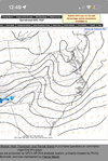
If you think this is the case, you need to get that phone charged asapYall can laugh… but that little one contour meso-high has been holding strong for 6 hours now. I think there’s a little sauce here for over performance on cold for tomorrow morning. I bet those high pressure contours in the wedge prove more difficult to moderate/equalize than models are showing. View attachment 188563
Hrrr doesn’t even start as sleet for any of us so these totals are prob too highI’ve got to stop looking. Make it stop View attachment 188562
NWMSGuy
Member
Well as I am under an Ice Storm Warning back in MS I am asking the question, where the hell is it? We are sleet city around here and I hope it stays that way but…wow, will this ice storm verify?
Ron Burgundy
Member
mydoortotheworld
Member
I know we are focused on GA SC NC but Jesus. Look at Texas, LA, AK, MS. Are they going to make it alive????The latest HRRR 16z holding on to specifically the CAD is generally solid by tomorrow AM in GA to cause some troubles even west of ATL. This is 5AM and probably looking at a window of a few more hours of CAD before it erodes away.
View attachment 188558
Tell them no. That’s an easy one.Another church in the Raleigh area is asking me what I think they should do with canceling services tomorrow they are contemplating having just one service at 11 am don’t know what to tell them
Sent from my iPhone using Tapatalk
NEGaweather
Member
Sleeting again in Commerce
Sent from my iPhone using Tapatalk
Sent from my iPhone using Tapatalk
rburrel2
Member
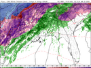
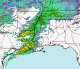
Just look at the old model runs for yourself. The models that have that convection and race it farther to the east… lead to more initial precip in central SC/eastern NC early on.Folks have been talking about the convection along the gulf that would aid in moisture transport NE. Has there been any verification of this? Latest radar does show the convection:
View attachment 188565
The hi-res models that were bone dry don’t have that convection racing east… and all the precip streams in a perfect curve as far north and west of us as possible, limiting the southern edge.
BufordWX
Member

