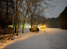
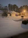
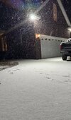
Snow globe right now
-
Hello, please take a minute to check out our awesome content, contributed by the wonderful members of our community. We hope you'll add your own thoughts and opinions by making a free account!
You are using an out of date browser. It may not display this or other websites correctly.
You should upgrade or use an alternative browser.
You should upgrade or use an alternative browser.
Wintry January 21-23 2025
- Thread starter SD
- Start date
Webberweather53
Meteorologist
Building off some of the things I mentioned earlier
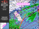
Mesoscale Discussion 0053
NWS Storm Prediction Center Norman OK
0801 PM CST Tue Jan 21 2025
Areas affected...central and eastern portions of the Carolinas
Concerning...Heavy snow
Valid 220201Z - 220700Z
SUMMARY...Moderate to heavy snow should gradually become widespread
through early tonight across portions of the central and eastern
Carolinas.
DISCUSSION...700 mb warm-air and moisture advection are increasing
over central and eastern parts of the Carolinas with the approach of
a pronounced 500 mb trough that is traversing the central
Appalachians. Beneath the 700 mb moistening, strong surface-850 mb
cold-air advection is contributing to further saturation and
sensible cooling of the column to support a predominance of snow,
which is currently being indicated by surface observations on a
widespread basis. Ahead of the upper trough, 700 mb frontogenesis is
intensifying, which should support increased snowfall rates. As
such, in addition to the transition to snow, 0.5-1.0 inch/hour
snowfall rates may develop over the next couple of hours, as also
suggested by some of the latest high-resolution guidance runs.
..Squitieri.. 01/22/2025
...Please see www.spc.noaa.gov for graphic product...
ATTN...WFO...AKQ...MHX...RAH...ILM...CHS...CAE...GSP...
LAT...LON 31968072 32388112 33088159 33798169 34438124 35427983
35787825 36017695 36227604 35877554 35337562 34927650
34557721 34057805 33607881 32857959 32288042 31968072
southernskimmer
Member
- Joined
- Dec 14, 2016
- Messages
- 63
- Reaction score
- 137
Periods of snow & sleet mixing in at Holden beach. I’m across the street from the ocean so the gradient will be interesting to observe.
WxBlue
Meteorologist
0.5" in spots already. Pouring at a decent pace. Probably 0.5-1" per hour rate, judging by my past experiences in the Northeast.
beanskip
Member
Well, this is turning into a frustrating night in Tallahassee. A beautiful burst of snow when precip started around 5 p.m. was a bit of a false signal.
Since then it has been a mix of sleet and freezing rain. Snow has been reported less than 10 miles to my north and west, but has not returned here.
Meanwhile, power outages have begun in Tallahassee -- 2,000 down now .. sure to grow.
The RAP is insisting on a changeover to snow imminently but the HRRR has now ominously flipped to sleet remaining the precip of choice for virtually the entire duration of the storm, which would obviously be hugely disappointing.
Anyway, long way to go, but ready to see some cotton balls.
Current conditions: IP/ZR mix, 30.6 F.
It's a race for accumulations. There should be plenty of 2+ reading across the Triangle.I say we got 90-120mim left
21/18 ripping
- Joined
- Jan 23, 2021
- Messages
- 4,602
- Reaction score
- 15,197
- Location
- Lebanon Township, Durham County NC
We’re gonna end close to two hereIt's a race for accumulations. There should be plenty of 2+ reading across the Triangle.
Pixie dust flakes by the millions, if they would just increase in size. Little over 1/2 so far but running out of time
I believe this is what Webber was alluding to a couple hours ago.View attachment 166634
Mesoscale Discussion 0053
NWS Storm Prediction Center Norman OK
0801 PM CST Tue Jan 21 2025
Areas affected...central and eastern portions of the Carolinas
Concerning...Heavy snow
Valid 220201Z - 220700Z
SUMMARY...Moderate to heavy snow should gradually become widespread
through early tonight across portions of the central and eastern
Carolinas.
DISCUSSION...700 mb warm-air and moisture advection are increasing
over central and eastern parts of the Carolinas with the approach of
a pronounced 500 mb trough that is traversing the central
Appalachians. Beneath the 700 mb moistening, strong surface-850 mb
cold-air advection is contributing to further saturation and
sensible cooling of the column to support a predominance of snow,
which is currently being indicated by surface observations on a
widespread basis. Ahead of the upper trough, 700 mb frontogenesis is
intensifying, which should support increased snowfall rates. As
such, in addition to the transition to snow, 0.5-1.0 inch/hour
snowfall rates may develop over the next couple of hours, as also
suggested by some of the latest high-resolution guidance runs.
..Squitieri.. 01/22/2025
...Please see www.spc.noaa.gov for graphic product...
ATTN...WFO...AKQ...MHX...RAH...ILM...CHS...CAE...GSP...
@Meteorologist1999 check in
WxBlue
Meteorologist
We're at 20.5 F/18.6 F. One of colder snow events I ever seen here in central NC.
- Joined
- Jan 23, 2021
- Messages
- 4,602
- Reaction score
- 15,197
- Location
- Lebanon Township, Durham County NC
The snow tonight is reflecting like it’s almost little pieces of diamond dust
WxBlue
Meteorologist
Shaggy
Member
mx3gsr92
Member
Huge flakes falling here in Moyock, NC. Approximately 20.5 miles to the NW of Corolla. Been stuck under a huge band for an hour now and it's just ripping. Hoping for some more magic to end it. Kids are pumped to go out in it tomorrow, freeze for 4 minutes, and then come right back inside.
Cary_Snow95
Member
Should make it to 2” here
Noticing that in the lights, too. I think it’s so high ratio / dry.The snow tonight is reflecting like it’s almost little pieces of diamond dust
Just got done walking the dog for an hour and a half. Doggie got a long walk because I wanted to be out there, too lol!
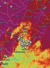
Is that Charlotte? Based on radar on thought you guys were basicallly done!rates really picking up now!
View attachment 166645
If radar can be believed I think it’s going to stop here in the next 30-60 minutes but I’ll hold out hope for a pivot or back building hah. We definitely have at least an inch and maybe edging past 1.5”? Not sure, I’ll measure after it’s over if I can find a good spot, probably.
Snow globe mentioned a few times here. Very good description. I'd say we're pushing 1.5'' a few miles SE of RDU.
Astounding to experience a snowfall around these parts with temps in low 20's.
Astounding to experience a snowfall around these parts with temps in low 20's.
broken025
Member
All done here. Under an inch but still nice. Maybe one day we will get another 6 inch storm. It’s been 11 years.
Chased to parents in HartsvilleIs that Charlotte? Based on radar on thought you guys were basicallly done!
If radar can be believed I think it’s going to stop here in the next 30-60 minutes but I’ll hold out hope for a pivot or back building hah. We definitely have at least an inch and maybe edging past 1.5”? Not sure, I’ll measure after it’s over if I can find a good spot, probably.
Man can’t believe it !! coming down pretty good at the house. 3.5 and counting.@Meteorologist1999 check in
Cary_Snow95
Member
Looks like maybe 30 minutes left in Cary. Back edge is speeding in
- Joined
- Jan 23, 2021
- Messages
- 4,602
- Reaction score
- 15,197
- Location
- Lebanon Township, Durham County NC
Watch your speed through MacBeeChased to parents in Hartsville
Sctvman
Member
It’s still ripping here. Heaviest of the night. Quickly closing on an inch. If it just finished for you I’ve got about 15 minutes to get thereAll done here. Under an inch but still nice. Maybe one day we will get another 6 inch storm. It’s been 11 years.
WxBlue
Meteorologist
KRDU observer reported 1" of snow with 0.05" of liquid... so roughly 20:1 ratio. Crazy.
broken025
Member
Finished at least 15 minutes ago. Hope you hold on longerIt’s still ripping here. Heaviest of the night. Quickly closing on an inch. If it just finished for you I’ve got about 15 minutes to get there
WxBlue
Meteorologist
Also, NWS Raleigh is reporting 1.1" at their office with 0.06" of liquid at nearby RDU. That'd be 18:1 ratio, rounded.
- Joined
- Jan 23, 2021
- Messages
- 4,602
- Reaction score
- 15,197
- Location
- Lebanon Township, Durham County NC
I’ve only seen one snow with a higher ratio in NC - 1/23/03. Officially 8” at KCLT with .18 liquid equivalent.Also, NWS Raleigh is reporting 1.1" at their office with 0.06" of liquid at nearby RDU. That'd be 18:1 ratio, rounded.
That’s a solid high ratio in the Piedmont. Maybe one day we can get a big dog again with these kind of ratios.Also, NWS Raleigh is reporting 1.1" at their office with 0.06" of liquid at nearby RDU. That'd be 18:1 ratio, rounded.
Cary_Snow95
Member
That’s the part that hurts. A cmc solution was possible with these same conditions and it easily would’ve produced foot+ totals for much of the state
That’s a solid high ratio in the Piedmont. Maybe one day we can get a big dog again with these kind of ratios.
How's SE Wake doing?
- Joined
- Jan 23, 2021
- Messages
- 4,602
- Reaction score
- 15,197
- Location
- Lebanon Township, Durham County NC
3K been screaming sleet along the 17 corridor for 48 hoursMan that’s uglyView attachment 166648

